


Click Image to Enlarge
Texas Counties
Texas is divided into two hundred and fifty-four counties, more than any other state. Texas was originally divided into municipalities, a unit of local government under Spanish and Mexican rule. When the Republic of Texas gained its independence in 1836, there were 23 municipalities, which became the original Texas counties. Many of these would later be divided into new counties. The most recent county to be created was Kenedy County in 1921. The most recent county to be organized was Loving County in 1931Nolan County, Texas
Nolan County Education, Geography, and History
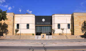
Nolan County is a county located in the west central region of the state of Texas. Based on the 2010 census, its population was 15,216. Its
county seat is Sweetwater. The county was created in 1876 and organized in 1881. It is named for Philip Nolan, one of the first American
traders to visit Texas.
Nolan County comprises the Sweetwater, TX Micropolitan Statistical Area.
Etymology - Origin of Nolan County Name
Philip Nolan, a mustanger who was killed by Spanish troops in 1801 while on a mission into Texas for uncertain reasons
Demographics:
County QuickFacts: CensusBureau Quick Facts
Nolan County History
Nolan County is a county located in the US state of Texas. Its seat is Sweetwater. The county is named for Phillip Nolan, one of the first American traders to visit Texas.
Handbook of Texas Online
The area of Nolan County had no Anglo settlers until after the Civil War,
when buffalo hunters came to the plains. The county was carved from the
Young-Bexar territory by the Texas legislature in 1876 and attached to Shackelford County for administrative
purposes. Knight's store on Sweetwater Creek was started in a dugout in 1877 to serve buffalo hunters operating in
the area. The county's first post office was opened in 1879 in the village of Sweet Water, which was two words until
the spelling was officially changed in 1918. The original name of the post office was Blue Goose, derived from a
story that the first postmaster ate a blue crane that cowboys told him was a blue goose. By 1880 there were
fifty-two ranches in the area, and the economy was dominated by the cattle industry. The agricultural census that
year reported 24,515 cattle, 1,300 sheep, and only sixty-four acres devoted to growing corn, the county's most
important crop at that time. The 1880 census reported 640 people living in the county. The county was organized
after an election held on January 20, 1881, and in April the Nolan County Court declared that Sweetwater was to be
the new permanent county seat. The townsite was on the Texas and Pacific Railway, which had built into the area that
March. The first newspaper in Nolan County, the Sweetwater Advocate, was published in 1881. Though a blizzard
in February 1885 destroyed much of the livestock in the area, settlers continued to move into Nolan County. By 1890
there were 144 ranches and farms, and the population had increased to 1,573. Ranching still dominated the local
economy at that time, though sheep had come to outnumber cattle in the area, 38,000 to 13,000. Meanwhile, 563 acres
were planted in corn, 900 acres in oats, and 490 acres in wheat. Hundreds of new settlers moved into the area during
the 1890s and early 1900s, establishing towns as they arrived. Roscoe, which grew on the site of a proposed Texas
and Pacific station called Vista, was incorporated in 1890, and the town's first newspaper, the Enterprise,
was published in 1893. Blackwell, originally named Jamestown, was built around a station on the Kansas City, Mexico
and Orient Railway about 1906, and Maryneal was established about the same time. Further settlement was encouraged
in 1908, when the Roscoe, Snyder and Pacific Shortline Railway was built to run fifty miles from Roscoe to Fluvanna.
Between 1897 and 1908 fifteen post offices were established in Nolan County. Reflecting these trends, the population
of the county rose to 2,611 by 1900 and to 11,999 by 1910 More at
Gerald McDaniel, "NOLAN COUNTY," Handbook of Texas Online (http://www.tshaonline.org/handbook/online/articles/hcn04),
accessed January 24, 2016. Uploaded on June 15, 2010. Published by the Texas State Historical Association.
Geography: Land and Water
As reported by the Census Bureau, the county has a total area of 914 square miles (2,367 km2), of which, 912
square miles (2,362 km2) of it is land and 2 square miles (5 km2) of it (0.21%) is water.
Neighboring Counties
Bordering counties are as follows:
- Fisher County (north)
- Taylor County (east)
- Runnels County (southeast)
- Coke County (south)
- Mitchell County (west)
Education


Click Image to Enlarge
