


Click Image to Enlarge
Texas Counties
Texas is divided into two hundred and fifty-four counties, more than any other state. Texas was originally divided into municipalities, a unit of local government under Spanish and Mexican rule. When the Republic of Texas gained its independence in 1836, there were 23 municipalities, which became the original Texas counties. Many of these would later be divided into new counties. The most recent county to be created was Kenedy County in 1921. The most recent county to be organized was Loving County in 1931Rockwall County, Texas
Rockwall County Education, Geography, and History
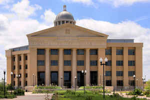
Rockwall County is the a county located in the state of Texas. At 129 square miles, Rockwall County has the smallest area of any county
in Texas. As of the 2014 census, its population was 87,809. Its county seat is Rockwall. The county and city are named for a wall-like
subterranean rock formation that runs throughout the county.
Rockwall County is part of the Dallas-Fort Worth-Arlington, TX Metropolitan Statistical Area.
Etymology - Origin of Rockwall County Name
A geological wall of rock running under the county
Demographics:
County QuickFacts: CensusBureau Quick Facts
Rockwall County History
Rockwall County was formed in 1873 from portions of Kaufman County. It split off because access to the county seat
of Kaufman was inconvenient. It was named for its county seat, Rockwall. The county and city are named for a wall-like
subterranean rock formation that runs throughout the county.
Handbook of Texas Online
The region around Rockwall County was the home of several tribes of Caddo Indians. Cherokees from east of the
Mississippi began to arrive in the area early in the nineteenth century, and as they spread, they almost annihilated
the peaceful, agricultural Caddoes. When the first Anglo-Americans arrived in the valley of the East Fork of the
Trinity sometime in the 1840s, they found these various Indian groups at war among themselves. The white settlers in
the area seem to have had little problem with them, however. The National Road
of the Republic of Texas was surveyed and constructed in the mid-1840s through
the area that would become Rockwall County. Running northeast from the Dallas area to the Red River, the road was a
major route for settlers traveling to Peters colony near the site of present-day
Dallas. In 1846 the first settler, John O. Heath, received a grant from the Mercer colony
and established his home on the East Fork of the Trinity River near the crossing of the Central National Road.
Occasionally when the swollen waters of the Trinity River prevented crossing, some families simply settled along the
east bank of the river. The towns of Heath and Rockwall were thus founded along the highway. The first post office
in the area was established in the Heath cabin in 1849 and named Black Hill. It operated there until 1855, when it
was transferred to the new village of Rockwall. During the 1850s other families continued to settle along the river,
while some moved eastward to the prairies to establish cattle ranches. Cattle raising was the principal industry in
the first years of settlement, although small lots were fenced for cultivation, and razorback hogs were raised. A
total of 240 pioneers came to hold original titles from the state. Several farmers were digging a well in 1851 when
they discovered a subterranean rock wall or diker that crossed the county and occasionally appeared at ground level.
Although scientific analysis indicated that the wall is a natural geological formation, folk tales persist that it
was built by prehistoric natives. When it was surveyed and laid out in 1854 the town of Rockwall was named for the
curious rock formation. In 1836 the area was established as part of Nacogdoches County, and when Texas joined the
Union in 1845, it was included in Henderson County. Kaufman County was formed in 1847, and the region now known as
Rockwall County was placed in the jurisdiction of the new county. In 1873, because the county seat, Kaufman, was
inconvenient for the residents of the northern panhandle, Rockwall County was formed, taking its name from the town
and geological formation. Rockwall was the first county seat and continues to hold that position, although in 1892
there was an unsuccessful attempt to make Fate the county seat. In 1873 Rockwall was incorporated. More at
Elizabeth Lee Bass, "ROCKWALL COUNTY," Handbook of Texas Online (http://www.tshaonline.org/handbook/online/articles/hcr10),
accessed January 24, 2016. Uploaded on June 15, 2010. Published by the Texas State Historical Association.
Geography: Land and Water
As reported by the Census Bureau, the county has a total area of 149 square miles (385 km2), making it the
smallest county in Texas. 129 square miles (334 km2) of it is land and 20 square miles (52 km2) of it (13.39%) is
water.
Neighboring Counties
Bordering counties are as follows:
- Collin County (north)
- Hunt County (east)
- Kaufman County (south)
- Dallas County (west)
Education
The following school districts serve Rockwall County:
Rockwall Independent School District (small portion in Kaufman County)
Royse City Independent School District (small portion in Collin, Hunt counties)


Click Image to Enlarge
