


Click Image to Enlarge
Texas Counties
Texas is divided into two hundred and fifty-four counties, more than any other state. Texas was originally divided into municipalities, a unit of local government under Spanish and Mexican rule. When the Republic of Texas gained its independence in 1836, there were 23 municipalities, which became the original Texas counties. Many of these would later be divided into new counties. The most recent county to be created was Kenedy County in 1921. The most recent county to be organized was Loving County in 1931Scurry County, Texas
Scurry County Education, Geography, and History
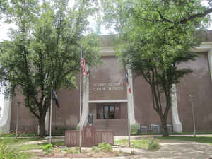
Scurry County is a county located in the state of Texas. Based on the 2010 census, its population was 16,921. Its county seat is Snyder,
which is the educational home for the fastest growing Texas Colleges, Western Texas College. The county was created in 1876 and organized in
1884. Scurry County was one of forty-six prohibition, or entirely dry, counties in the state of Texas, until a 2006 election approved the sale
of beer and wine in Snyder, and a 2008 election approved the sale of liquor by the drink throughout the county.
Scurry County comprises the Snyder, TX Micropolitan Statistical Area.
Etymology - Origin of County Scurry Name
William Read Scurry, a Texas state legislator and Confederate general who was killed at the Battle of Jenkins' Ferry
Demographics:
County QuickFacts: CensusBureau Quick Facts
Scurry County History
This county, lying directly north of Mitchell County, was created in 1876, and was organized June 28, 1884. It was
named for William Read Scurry, lawyer and Confederate Army general. Until 1909 it was without railroad facilities, and the nearest shipping
points were Colorado City on the south and still later the railroad towns in Fisher County on the east.
Its county seat is Snyder
Handbook of Texas Online
Scurry County was established by the Texas legislature in 1876 from lands formerly assigned to Bexar County; in
1880 there were 102 residents, including eight blacks, living in the area. The county was attached to Mitchell
County for judicial purposes until 1884, when it was organized. Snyder, the growing trading post, became a townsite
in 1882 and the county seat in 1884. A. C. Wilmeth began publishing the county's first newspaper, the Scurry
County Citizen, in the 1880s. By 1890 there were 184 farms and ranches, encompassing almost 142,000 acres, in
the county, and its population had increased to 1,415. Ranching dominated the local economy; that year almost 23,000
cattle and 17,000 sheep were reported in the county. Crop farming was also beginning to be established by that time,
as 822 acres were planted in corn and 246 acres were planted in wheat. The "Block 97 Controversy" kept ranchers and
homesteaders aroused for years before the dispute was settled by the legislature in 1899. The controversy centered
on 612,000 acres of land, mostly in Scurry County, that had been granted to the Houston and Texas Central Railroad
and the Texas and Pacific Railway Company. After selling land to settlers, the railroad became insolvent. Land
titles reverted to the state and homesteaders claimed land against the invalidated purchase rights of ranchers, who
were eventually required to repurchase in order to hold their lands. Despite this controversy the county developed
quickly during this period. By 1900 there were 586 farms and ranches in the area, and the population had increased
to 4,158. Cattle ranching dominated the local economy. Over 43,000 cattle, and about 3,000 sheep, were reported that
year. Meanwhile, crop farming continued to spread. Over 4,000 acres were planted in corn that year, and 701 acres in
wheat. Cotton had become the county's most important crop, however; that year more than 7,400 acres were devoted to
the fiber More at
John Leffler, "SCURRY COUNTY," Handbook of Texas Online (http://www.tshaonline.org/handbook/online/articles/hcs07),
accessed January 24, 2016. Uploaded on June 15, 2010. Published by the Texas State Historical Association.
Geography: Land and Water
As reported by the Census Bureau, the county has a total area of 908 square miles (2,350 km2), of which, 902
square miles (2,337 km2) of it is land and 5 square miles (13 km2) of it (0.55%) is water.
Neighboring Counties
Bordering counties are as follows:
- Kent County (north)
- Fisher County (east)
- Mitchell County (south)
- Borden County (west)
- Garza County (northwest)
Education


Click Image to Enlarge
