


Click Image to Enlarge
Texas Counties
Texas is divided into two hundred and fifty-four counties, more than any other state. Texas was originally divided into municipalities, a unit of local government under Spanish and Mexican rule. When the Republic of Texas gained its independence in 1836, there were 23 municipalities, which became the original Texas counties. Many of these would later be divided into new counties. The most recent county to be created was Kenedy County in 1921. The most recent county to be organized was Loving County in 1931Stonewall County, Texas
Stonewall County Education, Geography, and History
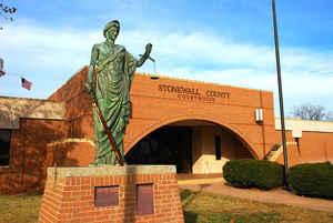
Stonewall County is a county located in the state of Texas. Based on the 2010 census, its population was 1,490. Its county seat is Aspermont. The county was created in 1876 and organized in 1888. It is named for Stonewall Jackson, a general of the Confederate States Army
Etymology - Origin of Stonewall County Name
Thomas Jonathan "Stonewall" Jackson, the famous Confederate General
Demographics:
County QuickFacts: CensusBureau Quick Facts
Stonewall County History
Stonewall County was formed in 1876 from portions of Bexar County and Young County. Its county seat is Aspermont. The county is named for Thomas Jonathan "Stonewall" Jackson, a general of the Confederate Army
Handbook of Texas Online
Stonewall was one of fifty-four counties formed by the Fifteenth Texas Legislature in 1876 from the Young and
Bexar districts. It remained attached to Young County for judicial and all other governmental purposes until March
31, 1887, when it was attached to Jones County for convenience. Stonewall County was still unorganized in 1880, when
the census found 104 people, including 91 whites, 10 blacks, and 3 Indians, living there. Settlers moved to the
county in increasing numbers during the 1880s. At first they settled a few miles south of the site of the present
county seat, but they eventually spread to the west and northeast. About the same time, ten families settled on the
east side of the county and established the community of Hooker. In 1888 the residents of the county petitioned the
Jones County Commissioners Court to hold an election for the organization of the county. The balloting took place on
December 20 of that year. However, the question of the county seat had been omitted from the ballot. On June 12,
1889, W. E. Rayner granted land for a townsite, and the new town of Rayner became the county seat. The courthouse, a
large stone building, was built the following year. By 1890 there were 1,024 people living in the county. The
agricultural census for that year found 144 farms there, encompassing more than 23,000 acres, 6,758 acres of which
was classified as "improved." The cattle industry dominated the local economy. Only 719 acres was planted in corn,
the county's most important crop at that time, while the agricultural census reported 5,023 cattle and 5,203 sheep.
As the county's population continued to expand in the 1890s, the placement of the county seat became a source of
local controversy. A. L. Rhomberg had secured a patent in February of 1889 and platted a town, Aspermont, which was
closer than Rayner to the center of the county. Beginning in 1892 the citizens of Aspermont made several attempts to
make their rapidly growing town the county seat, and finally succeeded after an election held in June 1898. The
controversy did not really end, however, until March 1900, when a contract to build a new courthouse in Aspermont
was signed. Rayner soon ceased to exist. More at
Joan Druesedow Griggs, "STONEWALL COUNTY," Handbook of Texas Online (http://www.tshaonline.org/handbook/online/articles/hcs16),
accessed January 24, 2016. Uploaded on June 15, 2010. Published by the Texas State Historical Association.
Geography: Land and Water
As reported by the Census Bureau, the county has a total area of 920 square miles (2,383 km2), of which, 918
square miles (2,379 km2) of it is land and 2 square miles (4 km2) of it (0.17%) is water.
Neighboring Counties
Bordering counties are as follows:
- King County (north)
- Haskell County (east)
- Jones County (southeast)
- Fisher County (south)
- Kent County (west)
Education


Click Image to Enlarge
