


Click Image to Enlarge
Texas Counties
Texas is divided into two hundred and fifty-four counties, more than any other state. Texas was originally divided into municipalities, a unit of local government under Spanish and Mexican rule. When the Republic of Texas gained its independence in 1836, there were 23 municipalities, which became the original Texas counties. Many of these would later be divided into new counties. The most recent county to be created was Kenedy County in 1921. The most recent county to be organized was Loving County in 1931Throckmorton County, Texas
Throckmorton County Education, Geography, and History
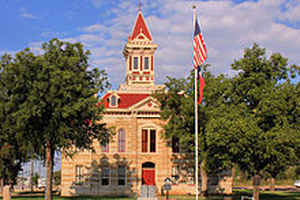
Throckmorton County is a county located in the state of Texas. Based on the 2010 census, its population was 1,641. Its county seat is Throckmorton. The county was created in 1858 and later organized in 1879. It is named for William Throckmorton, an early Collin County settler.
Etymology - Origin of Throckmorton County Name
William Edward Throckmorton, an early Collin County settler
Demographics:
County QuickFacts: CensusBureau Quick Facts
Throckmorton County History
The Spanish explorer Pedro Vial is considered to be the earliest European to travel through what is now known
as Throckmorton County. Vial passed between the Clear Fork and Main Fork of the Brazos River in 1786 while searching for a direct route
between San Antonio and Santa Fe. No other major activity is recorded in the county until 1849, when Captain Randolph B. Marcy, commander of a
US military escort expedition led by Lieutenant J. E. Johnson, passed through the county.
In 1837, the Republic of Texas established Fannin County, which included the area now known as Throckmorton County. In 1858, Throckmorton
County was officially established. Williamsburg was designated as county seat. The county was named in honor of Dr. William E. Throckmorton,
an early north Texas pioneer and the father of James W. Throckmorton, who later became governor of Texas. Organization of the county was
delayed until 1879, when Throckmorton was named the county seat.
Handbook of Texas Online
The area that is now Throckmorton County was a part of Red River Municipality until 1837, when it became part of
mewly organized Fannin County. In 1854 the Comanche Indian Reservation, (18,576
acres), was established at Camp Cooper on the Clear Fork of the Brazos. In 1855 some 450 Comanches of the Penateka
band settled there and tried to adapt to an agricultural economy. John R. Baylor,
Indian agent from 1855 to 1857, settled his family at Camp Cooper in 1856. That same year Lt. Newton C.
Givens built a stone ranch house near the old California Trail and the Haskell
county line. At the time this was the last house between Texas and New Mexico settlements. The Butterfield Overland
Mail route crossed the area, and Franz Station was a well-known stop. The Texas
legislature established Throckmorton County in 1858, and Williamsburg initially was chosen to be the county seat. In
1859 the Comanche reservation was relocated to Indian Territory, and by 1860 the United States census found only 124
people living in the county. The outbreak of the Civil War also impeded
settlement of the area, and the county remained unorganized for almost twenty years after it was formed.
Throckmorton County was organized in 1879, and the town of Throckmorton, located near the center of the county,
became the county seat. Early businesses included a store operated by a Mr. Tadley and a restaurant-stage stand run
by C. A. (Alex) Housley. By 1880 sixty-eight ranches or farms operated in the area. Though some crops were raised,
cattle ranching was the mainstay of the economy. Fewer than 900 acres was planted in corn, the county's most
important crop in 1880, while almost 32,000 cattle and more than 7,000 sheep were reported on ranches that year.
Ranching continued to dominate the economy during the 1880s and 1890s, and by 1900 almost 47,000 cattle and 4,000
sheep were reported. Crop farming slowly expanded during this period, however. By 1900 almost 5,000 acres was
planted in corn, and 3,000 acres was devoted to cotton. There were 272 farms and ranches, encompassing 635,000
acres, that year. As agriculture expanded in the area, the population rose to 902 by 1890 and to 1,750 by 1900. One
of the most important ranches in the area, the SMS Ranch, was put into operation
during the late nineteenth century. Swante M. Swenson gained railroad and other
lands in parts of Throckmorton, Jones, Shackelford, Haskell, and Stonewall counties in 1854. His sons, E. P. and S.
A. Swenson, began fencing and running cattle on the lands in the early 1880s. It took years of investment and work
to improve the ranches and the cattle breed, but by 1902 when Frank S. Hastings
became manager the "breed-well . . . feed-well" practice was paying off. The Swensons had 25,000 cattle on 350,000
acres, and Hastings began sending range-bred calves to be matured at feed lots in the Corn Belt. Hastings remained
manager until his death in 1922 More at
John Leffler, "THROCKMORTON COUNTY," Handbook of Texas Online (http://www.tshaonline.org/handbook/online/articles/hct05),
accessed January 24, 2016. Uploaded on June 15, 2010. Published by the Texas State Historical Association.
Geography: Land and Water
As reported by the Census Bureau, the county has a total area of 915 square miles (2,371 km2), of which, 912
square miles (2,363 km2) of it is land and 3 square miles (8 km2) of it (0.34%) is water.
Neighboring Counties
Bordering counties are as follows:
- Baylor County (north)
- Young County (east)
- Stephens County (southeast)
- Shackelford County (south)
- Haskell County (west)
Education


Click Image to Enlarge
