


Click Image to Enlarge
Texas Counties
Texas is divided into two hundred and fifty-four counties, more than any other state. Texas was originally divided into municipalities, a unit of local government under Spanish and Mexican rule. When the Republic of Texas gained its independence in 1836, there were 23 municipalities, which became the original Texas counties. Many of these would later be divided into new counties. The most recent county to be created was Kenedy County in 1921. The most recent county to be organized was Loving County in 1931Val Verde County, Texas
Val Verde County Education, Geography, and History
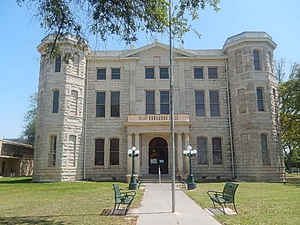
Val Verde County is a county located on the southern Edwards Plateau in the state of Texas. The 2014 population is 51,047. Its county
seat is Del Rio. In 1936, Val Verde County received Recorded Texas Historic Landmark number 5625 to commemorate its founding.
Val Verde, which means "green valley", was named for a battle of the American Civil War. In 1862, soldiers of Sibley's Brigade took part in
the Texas invasion of New Mexico Territory, where they captured several artillery pieces at the Battle of Val Verde. The battle is
memorialized both in the name of the county and a small settlement in Milam County.
The Del Rio, TX Micropolitan Statistical Area includes all of Val Verde County.
Etymology - Origin of Val Verde County Name
the Civil War Battle of Valverde, which took place near present-day Socorro, New Mexico
Demographics:
County QuickFacts: CensusBureau Quick Facts
Val Verde County History
Val Verde County is a county located in the US state of Texas. Its county seat is Del Rio.
Val Verde, which means "green valley," was named for a Civil War battle. In 1862, soldiers of Sibley's Brigade took part
in the Texas invasion of New Mexico Territory, where they captured several artillery pieces at the Battle of Val Verde.
The battle is memorialized both in the name of the county and a small settlement in Milam County.
Handbook of Texas Online
In February 1849 the Whiting and Smith expedition passed through the area. A
temporary base called Camp Blake was situated on the Military Road soon after
the Mexican War, and several other military bases were set up in southeastern
Val Verde County in the 1850s to protect settlers and travelers against Indian attack. Camp Hudson was founded on
San Pedro Creek on June 7, 1857. Camp San Felipe was established as an outpost of Fort Clark also in 1857. During
the Civil War military camps and forts were abandoned, leaving the frontier open
to frequent Indian attacks. Fort Clark was reclaimed by the army in 1866, and by 1868 other troops returned to the
area. From 1869 through 1882 the Black Seminole Scouts, a paramilitary unit of
fifty men under John Lapham Bullis, defended the Texas border west of Fort Clark
against Indian attack. The community of San Felipe was settled on San Felipe Creek in 1868. The community was
sometimes called San Felipe Del Rio (for its proximity to the Rio Grande) to distinguish it from the San Felipe of
Austin's colony, and the post office, named Del Rio, was opened in 1872. In 1874 the first school was built at Del
Rio. Fifteen students were enrolled, and Judge Kratz taught the school through the 1870s. By the spring of 1884 a
church was built in Del Rio by the Episcopal diocese. Shortly after its completion the building was blown away by a
tornado, leaving the town again without a church. In the 1980s Val Verde County supported twenty-five churches. The
largest denominations were Catholic, Southern Baptist, and United Methodist. In 1883 the Galveston, Harrisburg and
San Antonio Railway was completed into the area, and new settlers came with the easy transportation. Several
communities were formed in Val Verde County in the 1880s. They were Langtry in 1884, Juno and Devils River in 1886,
Comstock in 1888, and Norris in 1889. Among the newcomers was Frank Qualia from Milan, Italy. In 1883 Qualia
established Val Verde Winery, where his grandson continued to make wine in the
1990s. Large sheep and cattle ranchers had come into the area by the 1880s. D. Hart Investments, a company which
established headquarters in the Pandale community in western Val Verde County, was one of these. Hart controlled a
large block of land and the watering places on both the Rio Grande and the Pecos River. He reportedly held 80,000
sheep, 500 horses, and a number of cattle there. Val Verde County was organized from Crockett, Kinney, and Pecos
counties in 1885. Its name, which is Spanish for "green valley," came from a Civil War battle. Del Rio became the
county seat. Also in the 1885 election Roy Bean of Langtry was elected justice
of the peace. Judge Bean became known as the Law West of the Pecos, and he measured out justice from his Jersey Lily
Saloon. In presidential elections Val Verde County supported Democratic candidates from 1888 until 1948, except in
1924 and 1928. Thereafter county voters were less predictable, favoring Democrats in 1960, 1964, 1968, 1976, and
1992. More at
Julia Cauble Smith, "VAL VERDE COUNTY," Handbook of Texas Online (http://www.tshaonline.org/handbook/online/articles/hcv01),
accessed January 24, 2016. Uploaded on June 15, 2010. Published by the Texas State Historical Association.
Geography: Land and Water
As reported by the Census Bureau, the county has a total area of 3,232 square miles (8,372 km2), of which,
3,170 square miles (8,211 km2) of it is land and 62 square miles (161 km2) of it (1.92%) is water.
Neighboring Counties
Bordering counties are as follows:
- Crockett County (north)
- Sutton County (northeast)
- Edwards County (east)
- Kinney County (east)
- Terrell County (west)
- Acu?, Coahuila, Mexico (south)
- Jim?ez, Coahuila, Mexico (south)
Education


Click Image to Enlarge
