


Click Image to Enlarge
Virginia Counties
The Commonwealth of Virginia is divided into ninety-five counties and thirty-eight independent cities, which are considered county-equivalents for census purposes.Amherst County, Virginia
Amherst County Education, Geography, and History
Amherst County is a county, located in the Piedmont region and near the center of the Commonwealth of Virginia. The county is
part of the Lynchburg, VA Metropolitan Statistical Area, and its county seat is Amherst.
Amherst County was created in 1761 out of Albemarle County, and it was named in honor of Lord Jeffery Amherst, the so-called "Conqueror of
Canada". The county was subsequently reduced in size in 1807 in order to give up land to form Nelson County. Tobacco was the major cash
crop of the county during its early years.
Based on the 2010 census, the population of the county was 32,353
Etymology - Origin of Amherst County Name
Amherst County was formed in 1761, from parts of Albemarle County. The county was named for Sir Jeffrey Amherst, known as the "Conqueror of Canada". Jeffrey Amherst was named Governor of Virginia, although he never came to the colony.
Demographics:
County QuickFacts: CensusBureau Quick Facts
Amherst County History
Amherst County was named for Major Jeffery Amherst, British commander in North America during the French and Indian War and governor of Virginia from 1759 to 1768. Amherst County, Virginia formed from Albemarle County and certain islands in the Fluvanna River in 1761. Its area is 470 square miles, and the county seat is Amherst. [Virginia Counties: Those Resulting from Virginia Legislation, by Morgan Poitiaux Robinson, originally published as Bulletin of the Virginia State Library, Volume 9, January, April, July 1916, reprinted 1992 by Genealogical Publishing Co., Inc., Baltimore, MD.]
Amelia County was named for Amelia Sophia Eleanora, daughter of George II of England, was created by a
legislative act in 1734, and in 1735, it was created from Prince George and Brunswick Counties in 1734. Then, in
1754, Prince Edward County was formed from Amelia County, and later the County was reduced to its current size when
Nottoway County was separated in 1789.Its area is 366 square miles and the county seat is Amelia. The population is
11,400 according to the 2000 census.
During the Revolutionary War, in 1781, Amelia was raided by British forces under General Tarleton. Eighty-four years
later, the Amelia County records amazingly survived through the Civil War. According to legend, they were saved in
April, 1865 because Federal General George Custer, of Little Big Horn fame, placed a guard over the Amelia County
Clerk's Office with orders that all records be preserved.
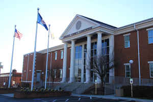
The County of Amelia's Courthouse, located on a two-acre square in the center of the village, was moved several
times before finally reaching its present location. The first Courthouse, located near Pridesville, was destroyed by
fire in 1766. Another location for the Courthouse was chosen at Dennisville. In 1849, the Courthouse was moved to
its present location. The Courthouse building presently in use was constructed in 1924. A Confederate Monument,
erected in 1905 by the Amelia Chapter of the United Daughters of the Confederacy, stands in the courtyard in honor
of the sons of Amelia County who served the Confederacy. General Robert E. Lee and his Army spent the days of April
4 and 5 at Amelia Courthouse on the retreat to Appomattox in 1865.
The last major battle of the Civil War was fought at what is now Sailor's (Sayler's) Creek Battlefield Historical
State Park located on the western edge of Amelia County. The 220-acre state-owned battlefield is operated by the
Virginia Department of Conservation and Recreation through its Division of State Parks. The Sailor's (Sayler's)
Creek site commemorates the battle which took place on April 6, 1865. In this battle alone, General Lee lost half
his army during the three days of conflicts. The Confederate Army suffered a crippling defeat which led to General
Robert E. Lee's surrender at Appomattox seventy-two hours later. The Hillsman House, restored in 1945 and located at
the park, was used as a federal field hospital during the battle. The park offers an audio tour with maps and
markers of the battlefield. Reenactments of the Sailor's (Sayler's) Creek Battle are also held in the park.
Geography: Land and Water
As reported by the Census Bureau, the county has a total area of 479 square miles (1,240 km2), of which 474 square miles (1,230 km2) is land and 4.9 square miles (13 km2) (1.0%) is water.
Neighboring Counties
Bordering counties are as follows:
- Rockbridge County, Virginia - northwest
- Nelson County, Virginia - northeast
- Appomattox County, Virginia - southeast
- Campbell County, Virginia - south
- Lynchburg, Virginia - south
- Bedford County, Virginia - southwest
Education


Click Image to Enlarge
