


Virginia Geography: The Land
Geography and Landforms of Virginia
 Find an overview of Virginia geography,
topography, geographic land regions, land areas, and major rivers.
Find an overview of Virginia geography,
topography, geographic land regions, land areas, and major rivers.
Access Virginia almanac furnishing more details on the state geography, geographical and land regions, climate and weather, elevation, land areas, bordering states, and other statistical data.
The climate of Virginia is mild and allows for a long growing season for farmers. The soil varies greatly throughout the state, ranging from very fertile in the Great Valley area to very sandy in the Tidewater area. Animal life is abundant and varied, and includes a variety of fresh and salt water fish and shellfish in the Tidewater area.
Virginia Highest, Lowest, & Mean Elevations |
|
|---|---|
| Mean Elevation | 950 ft. |
| Highest Point | Mt. Rogers 5,729 ft. |
| Lowest Point | Atlantic Ocean Sea level |
Virginia Land Area (Square Miles) |
|
| Geographic Center | In Buckingham County, 5 mi. SW of Buckingham Longitude: 78° 33.8'W Latitude: 37° 29.3'N |
| Total Area | 42,774.20 sq. mi. 35th |
| Land Area | 39,594.07 sq. mi. 92.57% |
| Water Area | 3,180.13 sq. mi. 7.43% |
| Forested Land Area | 63.1% |
| Dimensions (Length - Width) |
430 miles - 200 miles |
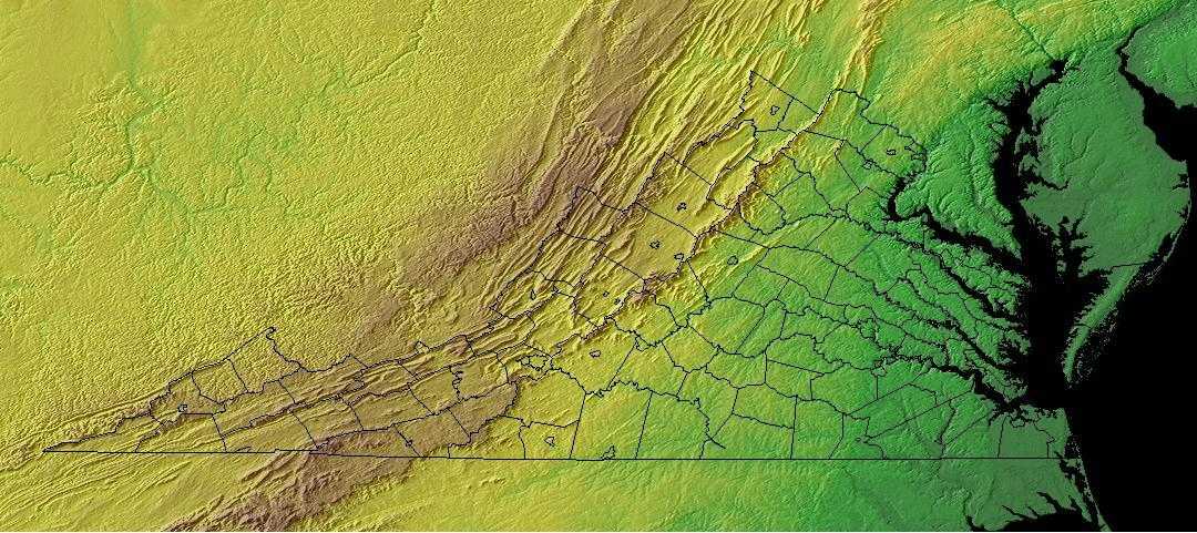
Virginia: Physiographic Regions
The state can be divided into five geographical regions:
- the Atlantic Coastal Plain,
- the Piedmont,
- the Blue Ridge,
- the Appalachian Ridge and Valley Region and the
- Appalachian Plateau.
Atlantic Coastal Plain
This lowland runs about 100 miles inland and is covered with salt marshes and swamps. It is also called the Tidewater because the water flows up and down the coastal inlets and bay as the tide moves in and out. This plain is divided into a mainland in the west and a peninsula that is called the East Shore, by Chesapeake Bay. The Atlantic Coastal Plain runs from north to south along the Atlantic Ocean.
The Mid-Atlantic Coastal Plain extends from the Atlantic Ocean, south of Long Island, to the Fall Line, where the hilly Piedmont begins. It is arbitrarily separated from the South Atlantic Coastal Plain at the Virginia-North Carolina border (with the exception of the Great Dismal Swamp in the southeast corner of Virginia, which is grouped in the southern area). The area was formed by shifting sea levels and alluvial deposition from rivers draining mountains to the west. Water continues to be a dominant feature of the landscape, creating forested wetlands and salt marsh and shaping barrier island and bay complexes. Upland forests on the remaining land graded in composition from pine dominated areas on the outer Coastal Plain (nearer the coast) to hardwood forests on the inner Coastal Plain. This was the site of the first successful English settlement in North America, and the natural landscape has been altered by European culture for nearly four centuries. The current human population approaches 11 million and is expected to continue to expand into the future, placing ever-increasing demands on the region's natural resources.
Piedmont
The Piedmont is to the west of the Atlantic Coastal Plain. It slopes upward from elevations of 200 to 300 feet above sea level in the east and 800 to 900 feet above sea level in the west. It is Virginia's largest geographical land region. It covers most of central Virginia. In the northeast the Piedmont is about 40 miles wide. It is about 140 miles wide at the North Carolina border. The rivers and streams in this area generally run in a southeasterly direction that breaks into low waterfalls the "fall line" where the Piedmont meets the Atlantic Coastal Plain.
The eastern border of the Piedmont is the fall line, where resistant volcanic rock gives way to the sands and clays of the Coastal Plain. To the west, the Piedmont ends with the edge of the higher and more rugged Blue Ridge and Ridge and Valley regions of the Appalachian Mountains The Mid-Atlantic Piedmont is arbitrarily separated from the Southern Piedmont at the North Carolina-Virginia line, and extends north through Virginia, Maryland, and Pennsylvania before terminating in northern New Jersey. The rolling topography of the Piedmont formerly supported an extensive hardwood forest, with an oak-hickory type predominant in southern portions and Appalachian oak to the north. Large areas in the Virginia portion were dominated by Loblolly-shortleaf pine or pine-oak forests. Today, roughly 45% of the physiographic area is forested, and about an equal portion is in agricultural production. The remainder is experiencing rapid urbanization, especially in the vicinity of Washington D.C. and Philadelphia.
Blue Ridge
The Blue Ridge lies to the west of the Piedmont. It rises steeply fro the Piedmont in the east, and in the west from the Appalachian Ridge and Valley Region. It is northeast of Roanoke, Virginia. The highest point in Virginia is Mount Rogers in the Blue Ridge. It is the main eastern mountain range of the Appalachian Mountains.
The Mid-Atlantic Ridge and Valley extends from western Maryland, through the mountains of Virginia and eastern West Virginia. Most of this physiographic
area consists of long mountainous ridges and intervening valleys, but it also includes the higher Allegheny Mountains of West Virginia. Predominant
vegetation consists of oak and oak-hickory forests on the ridges and northern hardwood forest in the Allegheny Mountains. Important relict patches
of spruce-fir exist in the Allegheny Mountains and on higher mountains along the ridge and valley of Virginia. Much of the lower valleys are in agricultural
production or urban development. Human populations are relatively sparse throughout the physiographic area and are largely confined to the larger valleys.
Suburban and second-home development is rapidly encroaching from large urban centers to the East. Timber extraction has been a major activity throughout
the history of this region, and it continues to be important on both public and privately owned forest lands. Extraction of minerals, oil and gas,
and coal are also important land uses throughout this region. At present, one of the most important disturbance factors affecting forested habitats
in this region is the prevalence and spread of native and exotic insect pests and disease. Beginning with American chestnut blight, a series of such
elements threaten the integrity and health of Appalachian forest ecosystems.
This region includes a wide strip of the Appalachian Mountains and the Blue Ridge Mountains. It is heavily forested and hide caverns and underground
streams.
Along the western edge of the mountains is the Allegheny Front, the place where the more sharp, rugged mountains of the east meet the more rolling
terrain of the Appalachian Plateau. Many of the peaks in this area of West Virginia rise to over 4,000 feet above sea level. Spruce Knob, the highest
point in West Virginia, rises 4,861 feet above sea level in the Appalachian Ridge and Valley Region.
The Southern Blue Ridge is an area of rugged mountains, long broad ridges, steep slopes, and deep ravines. It straddles the border between Tennessee and North Carolina, extending south into northeast South Carolina and northwest Georgia and north into Virginia. High Peaks spruce-fir forest grades at lower elevations into northern hardwood forest or hemlock-white pine forest on steep, north-facing slopes and Appalachian oaks on drier sites. The Appalachian oak type is the most widespread forest type in the area. Mixed mesophytic hardwood forests, also called cove forests, over on more mesic sites at low to mid-elevations. Various southern yellow pine mixes occur on dry ridges, often associated with a fire regime. There are also riparian forest types along valleys at various elevations, primarily in the lowlands. Disturbance, including fire, grazing, and storm damage, plays a major role in determining the distribution and successional status of many of these forest types.
Appalachian Ridge and Valley Region
Appalachian Ridge and Valley Region extends southwest to northeast along Virginia's western border. The Great Valley is sometimes called the Valley of Virginia. It lies along the Blue Ridge in the east. The Great Valley is a series of valleys divided by mountains. Shenandoah Valley is the most well known valley. This region is abundant with caverns carved into limestone.
Appalachian Plateau
The Appalachian Plateau is in the southwestern part of Virginia. It extends into Kentucky as the Cumberland Plateau. This area is covered with rivers, streams, and forests. The Appalachian Plateau averages about 2,000 feet above sea level.
This is a largely forested, gently rolling tableland ranging from 300 m. To 580 m. in elevation. It is defined by the higher Eastern Highland Rim of the Interior Low Plateaus on the west and the Cumberland Mountains of the Ridge and Valley physiographic area on the east. The Cumberland Plateau extends south out of this physiographic area, where it is included with the Southern Ridge and Valley, and narrowly northward as well. As defined, the Northern Cumberland Plateau includes the eastern third of Kentucky, southwestern West Virginia, a small area in western Virginia, and a swath across Tennessee barely extending into Alabama and Georgia. Mixed mesophytic forest dominated by oaks, hickory, and, historically, American chestnut, is the most common cover type. Various pine species become more dominant on drier sites.

