


Click Image to Enlarge
Virginia Counties
The Commonwealth of Virginia is divided into ninety-five counties and thirty-eight independent cities, which are considered county-equivalents for census purposes.Dickenson County, Virginia
Dickenson County Education, Geography, and History
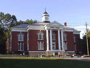
Dickenson County is a county located in the Commonwealth of Virginia. Based on the 2010 census, the population was 15,903.Dickenson County, formed in 1880 from parts of Buchanan County, Russell County, and Wise County, is Virginia's youngest county. It was named for William J. Dickenson, delegate to the Virginia General Assembly from Russell County, 1859–1861, 1865–1867, and 1877-1882. Its county seat is Clintwood
Etymology - Origin of Dickenson County Name
Dickenson is named for Virginia state legislator William J. Dickenson.
Demographics:
County QuickFacts: CensusBureau Quick Facts
Dickenson County History
Dickinson County, Virginia formed from Buchanan, Russell, and Wise Counties.
Dickenson County was named for William J. Dickenson, delegate to the General Assembly from Russell County in 1880 when Dickenson was formed from Russell, Wise and Buchanan Counties. Its area is 355 square miles, and its county seat is Clintwood
Geography: Land and Water
As reported by the Census Bureau, the county has a total area of 334 square miles (870 km2), of which 331 square miles (860 km2) is land and 3.1 square miles (8.0 km2) (0.9%) is water
Neighboring Counties
Bordering counties are as follows:
- Buchanan County, Virginia - northeast
- Russell County, Virginia - southeast
- Wise County, Virginia - southwest
- Pike County, Kentucky - northwest
Education
Clintwood High School, Clintwood
Haysi High School, Haysi


Click Image to Enlarge
