


Click Image to Enlarge
Virginia Counties
The Commonwealth of Virginia is divided into ninety-five counties and thirty-eight independent cities, which are considered county-equivalents for census purposes.Hanover County, Virginia
Hanover County Education, Geography, and History
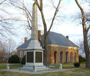
Hanover County is a county located in the Commonwealth of Virginia. Based on the 2010 census, the population was 99,863. Its county seat is
Hanover Courthouse.
Hanover County is included in the Richmond, Virginia, Metropolitan Statistical Area.
Etymology - Origin of Hanover County Name
Hanover is named for the Electorate of Hanover in Germany. George I was Elector of Hanover at the time when he also became King of England in 1714. In 1814, the Electorate of Hanover became a kingdom. Britain and Hanover remained in personal union through the reign of King William IV.
Demographics:
County QuickFacts: CensusBureau Quick Facts
Hanover County History
Hanover County, Virginia formed from New Kent County. Legislative enactment in 1720. Organized in 1721. A 20 Nov 1720 date is suggested by Robinson. (See p. 80.) [Virginia Counties: Those Resulting from Virginia Legislation, by Morgan Poitiaux Robinson, originally published as Bulletin of the Virginia State Library, Volume 9, January, April, July 1916, reprinted 1992 by Genealogical Publishing Co., Inc., Baltimore, MD.]
Hanover County was named for George I, who at the time of his ascent to the English throne was elector of Hanover in Germany. The county was formed from New Kent in 1720. Its area is 471 square miles, and the county seat is Hanover.
Geography: Land and Water
As reported by the Census Bureau, the county has a total area of 474 square miles (1,228 km2), of which, 473
square miles (1,224 km2) of it is land and 1 square miles (4 km2) of it (0.30%) is water.
It is bounded on the north by Spotsylvania, Caroline and King William counties; on the south by Goochland and
Henrico counties; on the east by New Kent County; and on the west by Louisa County.
Hanover County is about 90 miles south of Washington, D.C., and about 12 miles north of Richmond.
Neighboring Counties
Bordering counties are as follows:
- Caroline County, VA to the northeast
- Goochland County, VA to the southwest
- Henrico County, VA to the south
- King William County, VA to the northeast
- Louisa County, VA to the west
- New Kent County, VA to the southeast
- Spotsylvania County, VA to the north
Education
Hanover County has fifteen elementary schools, four middle schools, four high schools, one alternative school, and one technology school. The four high schools are Atlee High School, Hanover High School, Lee-Davis High School, and Patrick Henry High School.


Click Image to Enlarge
