


Click Image to Enlarge
Virginia Counties
The Commonwealth of Virginia is divided into ninety-five counties and thirty-eight independent cities, which are considered county-equivalents for census purposes.New Kent County, Virginia
New Kent County Education, Geography, and History
New Kent County is a county located in the eastern part the Commonwealth of Virginia. Based on the 2010 census, the population was 18,429.
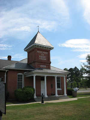
Its county seat is New Kent.
New Kent County is included in the Richmond, VA Metropolitan Statistical Area.
Etymology - Origin of New Kent County Name
New Kent County was named either for the English county of Kent or for Kent Island, in the upper waters of the Chesapeake Bay. William Claiborne, a native of Kent who had been driven from Kent Island by Lord Baltimore, was a prominent resident of the New Kent area about 1654 when the county was formed from York County.
Demographics:
County QuickFacts: CensusBureau Quick Facts
New Kent County History
New Kent County was established in 1654 from York County and was organized and settled by William Claiborne. The county's name
originated because several prominent inhabitants, including William Claiborne, recently had been forced from their settlement at Kent
Island, Maryland by Lord Baltimore upon the formation of Maryland. Claiborne had named the island for his birthplace in Kent, England. New
Kent County is the birthplace of two U. S. Presidents' wives - Martha Washington and Letitia Christian Tyler. The church where George and
Martha Washington are believed to have been wed, St. Peters, still holds services today. The Chickahominy Indians frequented this area as
well as nearby Charles City County and two tribes are still well-established in this area.
Among the earliest settlers of New Kent County was Nicholas Gentry, who settled in New Kent in 1684. The parish register books of St.
Peter's Parish show that Nicholas Gentry's daughter was baptized in the church in 1687. The records also reflect other Gentrys, probably
Nicholas Gentry's relations, Peter and Samuel Gentry. As the result of arson confessed to by John Price Posey and Tho Green, and,
allegedly, involving "a negro boy belonging to W. Chamberlayne" on 15 July 1787, many later county records were burned, making identifying
relationships between family members difficult.
In November of 1719, a portion of New Kent County known then as St. Paul's Parish was formed into a separate county, now Hanover County.
New Kent County formed from York and James City Counties. James City County gave only a small portion, possibly at a later date. [Virginia Counties: Those Resulting from Virginia Legislation, by Morgan Poitiaux Robinson, originally published as Bulletin of the Virginia State Library, Volume 9, January, April, July 1916, reprinted 1992 by Genealogical Publishing Co., Inc., Baltimore, MD.]
Geography: Land and Water
As reported by the Census Bureau, the county has a total area of 223 square miles (579 km2), of which, 210
square miles (543 km2) of it is land and 14 square miles (36 km2) of it (6.23%) is water. The Chickahominy River
borders the county to the south, the Pamunkey and York rivers border it to the north and east.
Neighboring Counties
Bordering counties are as follows:
- Charles City County, VA to the south
- Hanover County, VA to the northwest
- Henrico County, VA to the west
- James City County, VA to the southeast
- King and Queen County, VA to the east
- King William County, VA to the north
Education


Click Image to Enlarge
