


Click Image to Enlarge
Arkansas Counties
The first of the Arkansas' seventy-five present-day counties created, Arkansas County was formed on 13 December 1813, when this area was part of the Missouri Territory.Bradley County, Arkansas
Bradley County Education, Geography, and History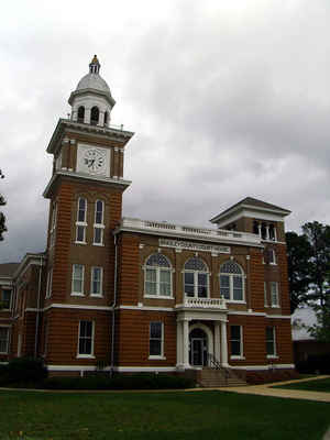
Bradley County is a county located in the state of Arkansas. Based on the 2010 census, the population was 11,508. The county seat is Warren. This county was formed on December 18, 1840. Bradley county was named for Captain Hugh Bradley, who fought in the War of 1812.
Etymology - Origin of Bradley County Name
Bradley is named for Hugh Bradley, a soldier in the War of 1812.
Hugh Bradley (May 23, 1885 in Grafton, Massachusetts - January 26, 1949 in Worcester, Massachusetts) played first base in Major League Baseball from 1910 to 1915.
Demographics:
County QuickFacts: CensusBureau Quick Facts
Bradley County History
Bradley county was created in December 18, 1840, from parts of Union, Cleveland, and Drew and Ashley counties. The county was named for William H. Bradley who had been with Andrew Jackson at the Battle of New Orleans and later settled in Arkansas. The county seat is Warren. All of the county's records are conserved in the courthouse. The first deed dates from March 29, 1841, and the first court records from April 1841. The County's structure today is the third county courthouse. Its predecessors were replaced because they were outgrown, not because of as in a number of Arkansas counties, being destroyed by fire. Pine timber is the mainstay of the economy with Potlatch Corp owning 300,000 acres and being the largest taxpayer. The county has nearly as many miles of company roads as county roads. Bradley County, however, is the tomato-raising capital of the state; and the General Assembly declared the South Arkansas vine-ripened pink tomato the official state fruit and vegetable. The famous Felsenthal Refuge features boating, hunting and fishing and is very poplar with the sportsmen.
Bradley county is an alcohol prohibition or dry county.
Geography: Land and Water
As reported by the Census Bureau, the county has a total area of 653 square miles (1,690 km2), of which 649 square miles (1,680 km2) is
land and 3.7 square miles (9.6 km2) (0.6%) is water.
The Ouachita River runs along the southwest edge of the county. The Mississippi Embayment extends to the Saline River valley along the east and southeast edge of Bradley County. The Saline River (Ouachita River) flows along most of the east edge of the County. The L'Aigle Creek
(Saline River of the Ouachita River) drains most of the area in the County.
Neighboring Counties
Bordering counties are as follows:
- North: Cleveland County
- Northeast: Drew County
- Southeast: Ashley County
- Southwest: Union County
- Northwest: Calhoun County
Education


Click Image to Enlarge
