


Arkansas Geography: The Land
Geography and Landforms of Arkansas
Find an overview of Arkansas geography, topography, geographic land regions, land areas, and major rivers.
Access Arkansas almanac, furnishing more details on the state geography, geographical and land regions, climate and weather, elevation, land areas, bordering states, and other statistical data.
Arkansas covers 53,182 square miles. The highest point is Magazine Mountain at 2,753 feet above sea level, and the lowest point is the Ouachita River at 55 feet above sea level. Arkansas contains a variety of landforms - from hilly landscapes and ridges and valleys to nearly flat terraced plains. The present day landforms in Arkansas are a result of the actions of past geologic processes, such as weathering and erosion that continue to the present day and the action of streams and rivers.
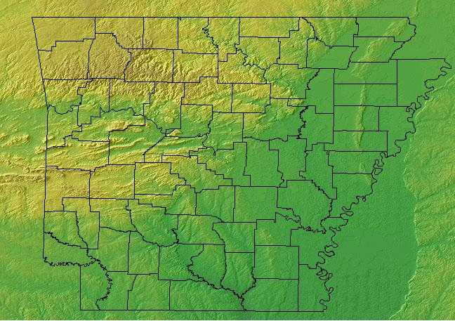
Arkansas can be divided into five main land regions; the Ozark Plateau, the Arkansas River Valley, the Ouachita Mountains, the Mississippi River Alluvial Plain, and the West Gulf Coastal Plain.
Arkansas Highest, Lowest, & Mean Elevations |
|
|---|---|
| Mean Elevation | 650 ft. |
| Highest Point | Magazine Mountain 2,753 ft. |
| Lowest Point | Ouachita River 55 ft. |
Arkansas Land Area (Square Miles) |
|
| Geographic Center | In Pulaski County, 12 mi. SW of Little Rock Longitude: 92° 18.1'W Latitude: 34° 48.9'N |
| Total Area | 53,178.62 sq. mi. 29th |
| Land Area | 52,068.17 sq. mi. 97.92% |
| Water Area | 1,110.45 sq. mi. 2.08% |
| Forested Land Area | 56.4 percent |
| Dimensions (Length - Width) |
260 miles - 240 miles |
Arkansas: Physiographic Regions
Arkansas is divided topographically into two major regions along a northeast--southwest trending "fall line". The emphasis here will be the five divisions:
- ;the Ozark Mountains (a.k.a. the Ozark Plateau or Plateaus),
- the Ouachita Mountains,
- the Arkansas River Valley,
- the West Gulf Coastal Plain, and the
- Mississippi River Alluvial Plain (a.k.a. the Arkansas Delta).
{Ozark Plateau}
The Ozarks and Ouachitas are two distinct mountain ranges separated from each other by the Arkansas River Valley. The Ozarks occupy most of southern Missouri and extend into northern Arkansas. They consist of three dissected plateaus covered with oak-dominated forest with glade and savannah inclusions.
The Ozark Plateau physiographic region of Arkansas encompasses more than one million acres located mostly in northwestern Arkansas. The Ozark surface features were created as water eroded the plateau. This process took millions of years and shaped the Ozarks into its present rugged shape. Caves, such as Blanchard Springs Caverns, were formed by streams flowing through cracks in the limestone. These streams carved mountains out of the plateau. They made bluffs, waterfalls, and natural dams. The forest of the Ozarks is predominately oak and
{Ouachita Mountains}
The Ouachita Mountains is one of two major ranges in the United States that runs east to west. The Ouachita River runs through a section of the mountains. The Ouachita Mountain Region is on the western side of Arkansas with the Gulf Coastal Plain to the south and the Arkansas River Valley to the north. These mountains extend into Oklahoma and range from 300' to 2,681'. They consist mostly of Paleozoic sandstones, shale and novaculites. The most prominent hard rock mineral is quartz crystal for which this region is known. The world-famous Hot Springs are located in the Ouachita Mountains north of Lake Hamilton.
To the south, the Ouachitas are a ridge and valley system covering central Arkansas and extending into eastern Oklahoma. Here shortleaf pine is interspersed with deciduous forest. The physiographic area transforms into prairie to the north and west and drops off into the Mississippi Alluvial Valley to the east and the West Gulf Coastal Plain to the south. The Ozark/Ouachitas are similar in many respects to the Interior Low Plateaus that lie directly to the east of the Mississippi Valley.
{Arkansas River Valley}
The Arkansas River Valley is a forty mile wide stretch between the Ozarks and the Ouachitas Mountains. It is characterized by uplifted plateaus, folded ridges and unique mountains with steep sides and flat tops (mesas). Most of the river valley is rolling upland with wide bottomlands and deep, fertile soil along the Arkansas River, which is the largest river in the state. There are bands of pine and hardwood, areas with pure hardwood or expanses of prairie grasses, and extensive bottomland forests and swamps.
The Arkansas River is the largest river in the state. Magazine Mountain, the highest point in Arkansas, is found in the Arkansas Valley.
{West Gulf Coastal Plain}
The West Gulf Coastal Plain covers northwest Louisiana, southwest Arkansas, easternmost Texas, and the southeast corner of Oklahoma. In general, uplands are dominated by pines and bottomlands by hardwood forests. The pine is originally longleaf in the southern portion and shortleaf with a significant hardwood element in the northern portion. The southern edge of the physiographic area occurs where trees become less dominant and the grasslands of the Coastal Prairies begin. The West Gulf Coastal Plain extends east to the Mississippi Alluvial Valley and north to edge of the Ouachita highlands. Drier climate and changing soils to the west mark the edge of the distribution of pine in eastern Texas and the beginnings of the Oaks and Prairies physiographic area.
The Gulf Coastal Plain covers most of South Arkansas. Its principal cities include Texarkana, Hope, El Dorado, Camden, Magnolia, Monticello, and Pine Bluff. The most northern section stretches to Pulaski County in Central Arkansas, southwest to Sevier County and then south to the Louisiana line in Ashley County. Millions of years ago the Gulf Coastal Plain was once the north shore of the Gulf of Mexico. As the water receded, the region was covered in forest of virgin pine and hardwood. These forests are gradually disappearing because of the rapid increase in tree harvesting. As a result, ecosystems are being altered to make way for monocultures. The lowland region has some hills, but most of the area is flat. Rivers and lakes are found in the region. The Ouachita River, one of the major rivers in this region, has moved back and forth to create many oxbow lakes that have developed into popular fishing sites. The lowest point in the state is found on the Ouachita River in the West Gulf Coastal Plain of Arkansas.
{Mississippi River Alluvial Plains}
This area includes the floodplain of the Mississippi River that cuts into the Gulf Coastal Plain, extending north to and including the delta at the confluence of the Mississippi and Ohio Rivers and south toward the Gulf of Mexico. The Alluvial Valley includes most of eastern Louisiana, eastern Arkansas, northwest Mississippi, small portions of west Tennessee and Kentucky, the bootheel of Missouri, and the Cache River lowlands of Illinois. Nonforested marsh in southern portions of the floodplain is included in the Coastal Prairie physiographic area. Water shaped this land. The ridges and swales, levees, oxbows, and terraces of the Valley all resulted from meanderings and floods of the Mississippi River. Small changes in elevation determine how wet a site is, the plant community that grows there, and habitat conditions for birds.
The Mississippi Alluvial Plain lies along the Mississippi River and covers the eastern third of Arkansas. The Mississippi River forms most of the eastern border of Arkansas between Tennessee and Louisiana. Most of the region is level lowlands. Narrow strips of hills running north to south through the central Plain form Crowley's Ridge. This region is sometimes known as the Delta region. It is covered by rich soil carried by the Mississippi River and its tributaries.
The alluvial plain consists of both Pleistocene (Ice Age) and recent deposits of clay, silt, sand, and gravel that were laid down by the Mississippi River as it meandered across this broad floodplain.
Crowley's Ridge has deep, well-drained, loessial soils that support upland hardwood forest. The forests of that natural division are related to those east of the Mississippi River and have some eastern species that are found nowhere else in Arkansas.

