


Click Image to Enlarge
Arkansas Counties
The first of the Arkansas' seventy-five present-day counties created, Arkansas County was formed on 13 December 1813, when this area was part of the Missouri Territory.Columbia County, Arkansas
Columbia County Education, Geography, and History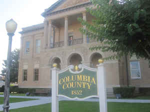
Columbia County is a county located in the state of Arkansas. Based on the 2010 census, the
population was 24,552. The county
seat is
Magnolia. The county was formed on December 17, 1852.
The county was named in honor of Columbia, a female
personification of the United States.
The Magnolia, AR Micropolitan Statistical Area includes all of Columbia County.
Etymology - Origin of Columbia County Name
Columbia is named for Columbia, a female personification of the United States. Columbia is a poetic name for the United States of America and for the feminine symbolic personification thereof.
Demographics:
County QuickFacts: CensusBureau Quick Facts
Columbia County History
Columbia county was created in December 1852, from parts of Lafayette, Hempstead, Union, and Ouachita counties, Columbia County was named from the time of the American Revolution and refers to the new American nation, derived from Christopher Columbus. The county name is in honor of Columbia, a female personification of the United States. The county seat is Magnolia. The stately old courthouse surrounded by the large magnolia trees is a landmark. Each year Columbia County holds a Magnolia Festival that brings people from far and near to enjoy the activities. Columbia County is rolling hills with good land for farming and forests for timbering and cotton as a cash crop. Cattle and poultry are raised throughout the county along with pine tree harvesting. Industry provides most jobs in the county. Southern Arkansas University is located in the county and Logoly State Park is situated on 345 acres of forested coastal plain with 11 natural springs, a visitor center and amphitheater. Lake Columbia, the newest reservoir, is separated into zones, some for fishing, some for pleasure boating, and some with multiple facilities available for recreation.
Columbia county was an alcohol prohibition or dry county. However, the voters of Columbia County voted on November 4, 2014 to make it legal to buy, sell, and manufacture alcohol within the county. The county will no longer be dry.
Geography: Land and Water
As reported by the Census Bureau, the county has a total area of 767 square miles (1,990 km2), of which 766 square miles (1,980 km2) is land and 0.7 square miles (1.8 km2) (0.1%) is water. Columbia County is in South Arkansas. Columbia County, along with Union County, is home to the largest Bromine reserve in the United States.
Columbia County is rolling hills with good farm land and forests for
timbering and cotton as a cash crop.
Dorcheat Bayou flows through Columbia County from its origin in Nevada County southward into Webster Parish, Louisiana, before emptying into
Lake Bistineau.
Neighboring Counties
Bordering counties are as follows:
- North: Nevada County
- Northeast: Ouachita County
- East: Union County
- Southeast: Claiborne Parish, La.
- South: Webster Parish, La.
- West: Lafayette County
Education


Click Image to Enlarge
