Crawford County, Arkansas
Crawford County Education, Geography, and History
Crawford County is a county located in the Ozarks region of the US state of Arkansas. Based on the 2010 census, the population was 61,948, making it the twelfth-most populous of Arkansas's seventy-five counties. The county seat and largest city is Van Buren. Crawford County was formed on October 18, 1820 from the former Lovely County and Indian Territory. Crawford county is named for William H. Crawford, the United States Secretary of War in 1815.
Crawford County is part of the Fort Smith metropolitan area. As a dry county, alcohol sales are generally prohibited, though recent changes to county law provide for exemptions.
Etymology - Origin of Crawford County Name
Crawford county is named for William Harris Crawford, the U. S. statesman and Secretary of War. William Harris Crawford (February 24, 1772 - September 15, 1834) was an important American politician, as well as a judge, during the early 19th century. He served as United States Secretary of War from 1815 to 1816 and United States Secretary of the Treasury from 1816 to 1825, and was a candidate for President of the United States in 1824.
Demographics:
County QuickFacts: CensusBureau Quick Facts
Crawford County History
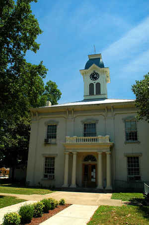
Crawford County was the biggest county in Arkansas when it was recognized in 1820. Originally, Crawford County included part of eight counties as well as part of the Indian Territory. Van Buren is the county seat. The main economic base of the county is agriculture and affiliated industries, soybeans, fruit and vegetables, beef cattle and poultry. Tourism is growing steadily with the lakes, rivers, mountains, valleys and the scenic views. Crawford County's Courthouse is listed in the National Historic Register and thought to be the oldest active county courthouse west of the Mississippi River. The original portion of the courthouse was constructed in 1842. People are attracted to historic downtown Van Buren that has six blocks of restored architecture, including arts, crafts and antique shops. Several motion pictures have been filmed in Van Buren. Crawford County's 2000 census count was 53,247, a 25.3% increase since 1990.
Geography: Land and Water
Crawford County is located in the northwest region of Arkansas. As reported by the Census Bureau, the county has a total area of 604 square miles (1,560 km2), of which 593 square miles (1,540 km2) is land and 11 square miles (28 km2) (1.8%) is water.
Located largely within the Ozarks, the southern border of the county is the Arkansas River, placing the extreme southern edge of the county in the Arkansas River Valley. The frontier county became an early crossroads, beginning with a California Gold Rush and developing into the Butterfield Overland Mail, Civil War trails and railroads such as the St. Louis and San Francisco Railway, the Little Rock and Fort Smith Railroad, and the St. Louis, Iron Mountain and Southern Railway. Crawford County is rocky terrain from the Ozark Mountains in the northern half and rolling farmlands, forested ridges and isolated mountains and lakes in the southern half.
Neighboring Counties
Bordering counties are as follows:
- North: Washington County
- Northeast: Madison County
- East: Franklin County
- South: Sebastian County
- Southwest: Le Flore County, Okla.
- West: Sequoyah County, Okla.
- Northwest: Adair County, Okla.
Education


