


Click Image to Enlarge
Arkansas Counties
The first of the Arkansas' seventy-five present-day counties created, Arkansas County was formed on 13 December 1813, when this area was part of the Missouri Territory.Polk County, Arkansas
Polk County Education, Geography, and History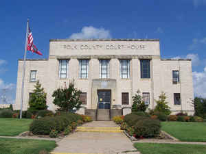
Polk County is a county located in the state of Arkansas. Based on the 2010 census, the population was 20,662. The county seat is Mena. Polk County was formed on November 30, 1844. The county is named for James Polk, President of the United States.
Etymology - Origin of Polk County Name
Polk county is named for James Knox Polk, the eleventh president of the United States. James Knox Polk,(November 2, 1795-June 15, 1849) was the eleventh President of the United States, serving from March 4, 1845 to March 4, 1849. Polk was born in Mecklenburg County, North Carolina, but mostly lived in and represented the state of Tennessee. A Democrat, Polk served as Speaker of the House (1835-1839) and Governor of Tennessee (1839-1841) prior to becoming president.
Demographics:
County QuickFacts: CensusBureau Quick Facts
Polk County History
Polk county was created in 1844, from part of Sevier County and was named after James K. Polk who was the newly elected President of the United States. The county seat is Mena. The economic base is made up of lumber and wood products, tree farming, cattle and poultry. Some light manufacturing and service industries contribute to the economy. Rich Mountain, the county's most prominent landmark, has a peak of 2,861 feet. It contains, in a single square mile, more species of wild plants, flowers, and weeds in their natural state than can be found anywhere else in the world on a similar tract of land. Situated on top of Rich Mountain is Queen Wilhelmina State Park with a lodge and restaurant, campsites and other attractions. A 300-acre lake at the foot of the mountain features excellent bank fishing. Many creeks and rivers are scattered through the county. The Ouachita, is a beautiful river, however only experienced canoeists need float. The four-story, stately courthouse building with a large seal of the State of Arkansas over the entrance, stands near the foot of Rich Mountain, one of the tallest mountains in the state. It is an alcohol prohibition or dry county
Geography: Land and Water
As reported by the Census Bureau, the county has a total area of 862 square miles (2,230 km2), of which 858 square miles (2,220 km2) is land and 4.8 square miles (12 km2) (0.6%) is water.
Long, narrow ridges of folded rock, large fertile valleys and mountains covered with oak and pine trees make up the landscape of the county. Nearly half of Polk County lies in the Ouachita National Forest.
Neighboring Counties
Bordering counties are as follows:
- Northeast: Scott County
- East: Montgomery County
- Southeast: Pike County; Howard County
- South: Sevier County
- Southwest: McCurtain County, Okla.
- Northwest: Le Flore County, Okla.
Education


Click Image to Enlarge
