


Click Image to Enlarge
Arkansas Counties
The first of the Arkansas' seventy-five present-day counties created, Arkansas County was formed on 13 December 1813, when this area was part of the Missouri Territory.Union County, Arkansas
Union County Education, Geography, and History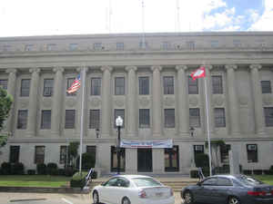
Union County is a county located in the state of Arkansas. Based on the 2010 census, the
population was 41,639. The county
seat is El
Dorado. The county was formed on November 2, 1829.
Union county is named in recognition of the citizens' petition for a new county, stating that they were
petitioning "in the spirit of Union and Unity." The county is directly adjacent to Union Parish in the state of Louisiana.
The El Dorado, AR Micropolitan Statistical Area includes all of Union County.
Etymology - Origin of Union County Name
Union county is named for the concept of Union which was threatened by the American Civil War. During the American Civil War, the Union was a name used to refer to the federal government of the United States, which was supported by the twenty-three states which were not part of the secession attempt by the 11 states that formed the Confederacy. Although the Union states included the Western states of California, Oregon, and (after 1864) Nevada, as well as states generally considered to be part of the Midwest, the Union has been also often loosely referred to as "the North", both then and now.
Demographics:
County QuickFacts: CensusBureau Quick Facts
Union County History
Union County Courthouse was Built from 1927 - 28 Greek revival by Mann & Stern architects of Little Rock National Register: 1983 the original Union County Courthouse, built in 1844 at a cost of $200 stood where Larry's Rexall Drug Store is today. As the county seat, El Dorado quickly outgrew even its second courthouse (built on this site in 1848) in the 1920's due to the oil boom's voluminous deed and title transactions. Faceted in smooth-dressed limestone, the third and current courthouse boasts 40 freestanding ionic exterior columns spanning four stories, and a richly detailed marble two-story atrium with art deco accents. The exterior medallions of the scales of justice and lanterns of light signify the search for truth. The building's largest courtroom features a walnut wainscot, painting and scoring on textured plaster walls to resemble stone, and an ornately detailed plaster cast ceiling of gilded rosettes. Back when the square was flanked by log cabin structures there was a large duck pond on this site. Emigrants camped on its banks. Many pioneer citizens recorded incidents where deer and even bears came to drink - and hunters would frequently bag their dinner by shooting the wild ducks that lit there in the mid-1800.
Geography: Land and Water
As reported by the Census Bureau, the county has a total area of 1,055 square miles (2,730 km2), of which 1,039 square miles (2,690 km2) is land and 16 square miles (41 km2) (1.5%) is water.
It is the largest county by area in Arkansas. Union County, along with Columbia County, has the largest bromine reserve in the United States. The lowest point in the state of Arkansas is located on the Ouachita River in Union County and Ashley County, where it flows out of Arkansas and into Louisiana
Neighboring Counties
Bordering counties are as follows:
- North: Calhoun County
- Northeast: Bradley County
- East: Ashley County
- Southeast: Morehouse Parish, La.; Union Parish, La.
- Southwest: Claiborne Parish, La.
- West: Columbia County
- Northwest: Ouachita County
Education


Click Image to Enlarge
