Van Buren County, Arkansas
Van Buren County Education, Geography, and History
Van Buren County is a county located in the state of Arkansas. Based on the 2010 census, the population was 17,295. The county seat is Clinton. The county was formed on November 11, 1833. Van Buren county is named for Martin Van Buren, President of the United States, who was Vice President at the time of the county's formation.
Etymology - Origin of Van Buren County Name
Van Buren county is named for US president Martin Van Buren Martin Van Buren (December 5, 1782 - July 24, 1862) was the eighth President of the United States from 1837 to 1841. Before his presidency, he served as the eighth Vice President (1833-1837) and the 10th Secretary of State under Andrew Jackson. He was a key organizer of the Democratic Party, a dominant figure in the Second Party System, and the first president who was not of British (i.e. English, Welsh or Scottish) or Irish descent. He was the first president to be born an American citizen (his predecessors were born before the revolution); he is also the only president not to have spoken English as a first language, having grown up speaking Dutch.
Demographics:
County QuickFacts: CensusBureau Quick Facts
Van Buren County History
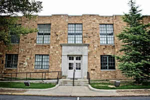
Van Buren county was formed on November 1833, from parts of Conway, Independence and Izard counties, in which the county was named after Martin Van Buren who was Vice President of the United States at that time, and Van Buren County was the 29th county of the State of Arkansas. Clinton is the county seat. The courthouse that has dimensions of only 100' x 43' is Arkansas's smallest courthouse in number of square feet of covered ground. The building was originally constructed under the Federal Emergency Administration of Public Works program but was remodeled in 1973. The economic base is small industry, cattle farming and tourism. The nationally known "Natural Bridge of Arkansas" is 100 feet long, 50 feet high and 4 feet thick. The bridge was actually used as a roadway until after the turn of the century. The Gulf Mountain Wildlife Management Area lures the hunter, the stream fisherman, nature lover and camper. The Brock, the Driver Creek, and the Little Red River areas offer hunting and camping. The most populous area of the county is Fairfield Bay, with more than 4,000 people. Greers Ferry Lake's, 40,000 acres of water offers boating, skiing, swimming, fishing and hunting is a popular area with thousands of visitors each year. The popular Sugar Loaf Mountain is an uninhabited island refuge for plant and animal life. An award winning hiking trail winds its way from the water's edge to the mountain summit. Van Buren County is a unique place. It is an alcohol prohibition or dry county.
Geography: Land and Water
As reported by the Census Bureau, the county has a total area of 724 square miles (1,880 km2), of which 708 square miles (1,830 km2) is land and 16 square miles (41 km2) (2.2%) is water.
The landscape of the county is rugged and mountainous in the north and rugged to rolling terrain in the south. The beauty of the Ozark Mountain with its waterfalls, natural bridges, and underground caverns are unique.
Neighboring Counties
Bordering counties are as follows:
- Northeast: Stone County
- East: Cleburne County
- Southeast: Faulkner County
- Southwest: Conway County; Pope County
- Northwest: Searcy County
Education


