


Click Image to Enlarge
Kentucky Counties
Kentucky has one hundred and twenty counties, third in the US behind Texas's (254) and Georgia's (159.) Washington County was the first county formed in the Commonwealth of Kentucky when it reached statehood, and the sixteenth county formedButler County, Kentucky
Butler County Education, Geography, and History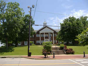
Butler County is a county located in the state of Kentucky. Based on the 2010 census, the
population was 12,690. The county was created in 1810.
The county seat is Morgantown. The
county is named for Richard Butler (1743–1791),
Revolutionary War General.
Butler County is included in the Bowling Green, KY Metropolitan Statistical Area.
Etymology - Origin of Butler County Name
The county is named for General Richard Butler (1743-1791), Revolutionary War officer; Superintendent of Indian Affairs for the Northern District; arranged the treaty of 1786 with the Shawnee and Delaware Indians
Demographics:
County QuickFacts: CensusBureau Quick Facts
Butler County History
Numerous archaeological sites are located along the Green River in Butler County. A 1932 survey found nine sites, many of which were a
group of shell mounds, including the Carlston Annis and DeWeese Shell Mounds.
The area now known as Butler County was first settled by the families of Richard C. Dellium and James Forgy, who founded a town called Berry's
Lick. The first industry was salt-making.
Butler county was formed in 1810. It is located in the Western Coal Field region of the state. The elevation in the county ranges from 385 to 810 feet above sea level. In 2000 the county population was 13,010 in a land area of 428.08 square miles, an average of 30.4 people per square mile. The county seat is Morgantown.
Butler County has one of only two Civil War monuments in Kentucky that honor the soldiers of both sides. The Confederate-Union Veterans' Monument in Morgantown, a zinc monument, was dedicated in 1907 on the Butler County Courthouse lawn.
The county is a prohibition or dry county.
Geography: Land and Water
As reported by the Census Bureau, the county has a total area of 431 square miles (1,120 km2), of which 426 square miles (1,100 km2) is land and 5.4 square miles (14 km2) (1.2%) is water.
Butler county is located in west Kentucky. This county is part of the Western Coal Fields region of Kentucky.
Neighboring Counties
Bordering counties are as follows:
- Northeast: Grayson County
- East: Edmonson County
- Southeast: Warren County
- Southwest: Logan County
- West: Muhlenberg County
- Northwest: Ohio County
Education


Click Image to Enlarge
