


Kentucky Geography: The Land
Geography and Landforms of Kentucky
 Find an overview of Kentucky geography,
topography, geographic land regions, land areas, and major rivers.
Find an overview of Kentucky geography,
topography, geographic land regions, land areas, and major rivers.
Access Kentucky almanac, furnishing more details on the state geography, geographical and land regions, climate and weather, elevation, land areas, bordering states, and other statistical data.
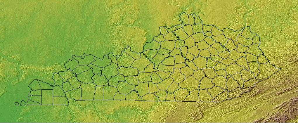
Kentucky, officially the Commonwealth of Kentucky is a state located in the east-central United States. It is bordered on the north by Illinois, Indiana, and Ohio; on the south by Tennessee; by West Virginia and Virginia on the east and Missouri borders Kentucky on the west. The geographic center of the state is in Marion County.
Kentucky Highest, Lowest, & Mean Elevations |
|
|---|---|
| Mean Elevation | 750 ft. |
| Highest Point | Black Mountain 4,139 ft. |
| Lowest Point | Mississippi River 257 ft. |
Kentucky Land Area (Square Miles) |
|
| Geographic Center | In Marion County, 3 mi. NNW of Lebanon Longitude: 84° 30.4'W Latitude: 37° 21.5'N |
| Total Area | 40,409.02 sq. mi. 37th |
| Land Area | 39,728.18 sq. mi. 98.32% |
| Water Area | 680.85 sq. mi. 1.68% |
| Forested Land Area | 49.9% |
| Dimensions (Length - Width) |
380 miles - 140 miles |
Kentucky: Physiographic Regions
Kentucky is composed of five geographic regions:
- Bluegrass Region
- Cumberland Plateau
- Western Coal Field
- Pennyroyal Region
- Jackson Purchase Region
Bluegrass Region
Located in the north-central area of the state is the Bluegrass Region. It extends into Ohio but is bordered in Kentucky on the north and west by the Ohio River. The land is rolling meadows in the central part and by sandstone (knobs) on the eastern, southern and western edges. This area is referred to as the Knobs Region.
Cumberland Plateau
The Cumberland Plateau is located in the eastern part of the state. It is made up of mountains, plateaus, and valleys. Black Mountain, the highest point in Kentucky is located in this region. The Cumberland and Pine Mountain ranges are also found in this part of the state. The Appalachian Plateau which extends from New York to Alabama is referred to as the Cumberland Plateau in Kentucky.
Western Coal Field
This area is called the Western Coal Field because of its large coal deposits. This land is bordered by the Ohio River in the north and the Pennyroyal region in the east, west and south. Farmland borders the Ohio River in the Western Coal Field.
Pennyroyal Region
The Pennyroyal (Pennyrile) runs south of Kentucky from the Appalachian Plateau west to the the Kentucky Lake. The southern part of this region are flat lands with some rolling hills. The Barrens lie in the center of this area and is a treeless region. Mammoth Cave is located in the Pennyroyal Region. The Pennyroyal Region gets its name from a small herb that grows there.
Jackson Purchase Region
This area is bordered on the east by the Kentucky lake. It is in the far western tip of Kentucky. To the north is the Ohio River; to the west, the Mississippi River.
This area is made up of flood plains with low hills. Reelfoot Lake, near the Tennessee border was created when the earthquakes in 1811 and 1812 caused the Mississippi River to flow backwards. The Mississippi River crosses the Madrid Fault zone here.
Kentucky Landscape and Landforms:
East Gulf Coastal Plain
The East Gulf Coastal Plain extends from the Florida Parishes of Louisiana over most of Mississippi, some of western Tennessee and Kentucky, the southwestern 2/3 of Alabama, and the western panhandle of Florida. Its southern boundary is the Gulf of Mexico and its western boundary the drop into the Mississippi Alluvial Valley. On the north it extends to the highlands of the Interior Low Plateaus and southern Appalachians. To the east, there is an arbitrary break with the South Atlantic Coastal Plain at the Alabama-Georgia border south through Florida along the Apalachicola River. The flat to rolling topography is broken by numerous streams and river bottoms. Uplands are dominated by pine, originally longleaf and slash in the south and shortleaf mixed with hardwoods in the north. These are fire-maintained systems that give way to loblolly pine and hardwoods in damper areas and bottomland hardwood forest in extensive lowland drainages.
Interior Low Plateaus
The Interior Low Plateaus constitute a diverse landscape that extends from north Alabama across central Tennessee and Kentucky into southern Illinois, Indiana, and Ohio. It consists of six distinct subregions: the Shawnee Hills, Bluegrass region, Western Highland Rim, Central Basin, Eastern Highland Rim, and Tennessee Valley. Its hilly topography sets it apart from the Coastal Plain to the south and Prairie Peninsula to the north. To the west, the valley of the Mississippi River separates the Interior Low Plateaus from the Ozark Highlands, the two of which share many similarities. Western mesophytic, oak-hickory, and beech-maple forests were historically the most abundant cover types. There were also tallgrass prairie elements in the north and northwest, oak savannahs in the Bluegrass and other northern sections, barrens and glades in central regions, and forested wetlands along major waterways
Mississippi Alluvial Valley
This area includes the floodplain of the Mississippi River that cuts into the Gulf Coastal Plain, extending north to and including the delta at the confluence of the Mississippi and Ohio Rivers and south toward the Gulf of Mexico. The Alluvial Valley includes most of eastern Louisiana, eastern Arkansas, northwest Mississippi, small portions of west Tennessee and Kentucky, the bootheel of Missouri, and the Cache River lowlands of Illinois. Nonforested marsh in southern portions of the floodplain is included in the Coastal Prairie physiographic area. Water shaped this land. The ridges and swales, levees, oxbows, and terraces of the Valley all resulted from meanderings and floods of the Mississippi River. Small changes in elevation determine how wet a site is, the plant community that grows there, and habitat conditions for birds.
Northern Cumberland Plateau
This is a largely forested, gently rolling tableland ranging from 300 m. To 580 m. in elevation. It is defined by the higher Eastern Highland Rim of the Interior Low Plateaus on the west and the Cumberland Mountains of the Ridge and Valley physiographic area on the east. The Cumberland Plateau extends south out of this physiographic area, where it is included with the Southern Ridge and Valley, and narrowly northward as well. As defined, the Northern Cumberland Plateau includes the eastern third of Kentucky, southwestern West Virginia, a small area in western Virginia, and a swath across Tennessee barely extending into Alabama and Georgia. Mixed mesophytic forest dominated by oaks, hickory, and, historically, American chestnut, is the most common cover type. Various pine species become more dominant on drier sites.

