

Click Image to Enlarge
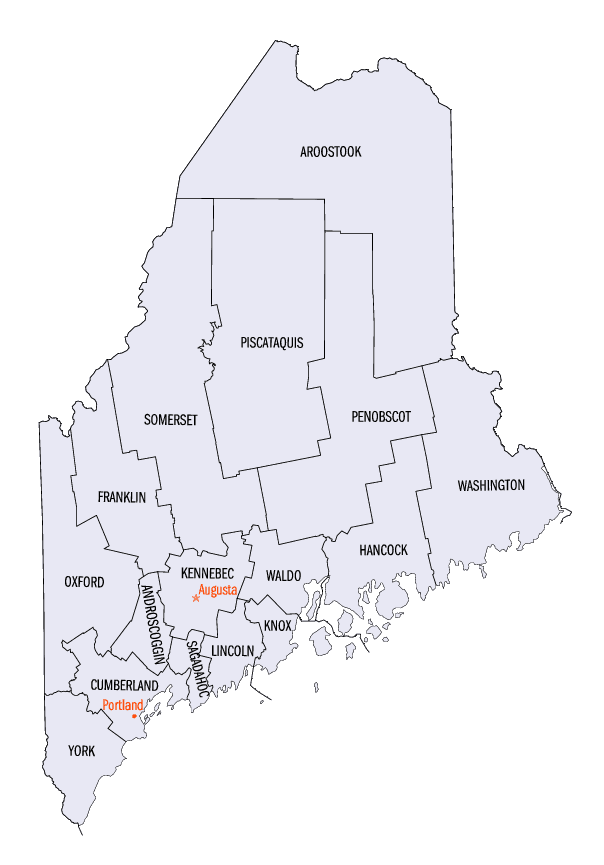
Maine Counties
There are sixteen Counties in Maine. Prior to statehood. The first county to be created was York County, created as York County, Massachusetts by the government of the Massachusetts Bay Colony in 1652. Maine was granted statehood on March 15, 1820 as part of the Missouri Compromise. Nine of the sixteen Counties had their borders defined while Maine was still part of Massachusetts, and hence are older than the state itself. Even after 1820, the exact location of the northern border of Maine was disputed with Britain, until the question was settled and the northern counties took their final, official form by treaty in 1845.Aroostook County, Maine
Aroostook County Education, Geography, and History
Aroostook County is a county located in the state of Maine. Based on the 2010 census, the population was 71,870. Its seat is Houlton.
Known locally in Maine simply as "The County," it is the largest American county by land area east of the Rocky Mountains (St. Louis County,
Minnesota is larger by total area) and the largest county by total area in Maine. As Maine's northernmost county, its northernmost village,
Estcourt Station, is therefore also the northernmost community in New England and in the contiguous United States east of the Great Lakes.
Etymology - Origin of Aroostook County Name
Aroostook is named for a Native American word meaning beautiful river.
Demographics:
County QuickFacts: CensusBureau Quick Facts
Aroostook County History
Aroostook County was formed in 1839 from parts of Penobscot and Washington counties. In 1843, Aroostook gained land from Penobscot County; in 1844, Aroostook again gained land from Penobscot, plus it exchanged land with Piscataquis County. In 1889, Aroostook gained slightly from Penobscot, but gave back the land in 1903 when Aroostook County gained its final form Some of the territory in this county was part of the land dispute that led to the "Aroostook War" that would eventually be settled by the Webster-Ashburton Treaty.
History of Aroostook County, Maine
From: A Gazetteer of the State of Maine
By Geo. J. Varney
Published by B. B. Russell, 57 Cornhill,
Boston 1886
Aroostook County embraces the north-eastern portion of the State; having New Brunswick for its eastern boundary, and
the Province of Quebec for its northern and western boundary,-both states of the British Dominion of Canada. On the
south its boundaries are within the State; and consist of Washington County on the east; succeeded in order by
Penobseot, Piscataquis and Somerset. The St. John and its branches, viz: the St. Francis, Allagash, Fish and
Aroostook are its principal rivers. The St. John has its rise in the western part and the adjacent territories, and
sweeps through and around its entire breadth from east to west, forming also about twothirds of its northern
boundary. In the south-eastern part, the St. Croix and the Mattawamkeag have their sources.
The entire northern part of Aroostook county might be denominated the valley of the St. John in Maine. It is a
valley as respects the western interior of the State, but a nearly level elevated plateau, with respect to the lower
part of the river. The St. John leaves our territory with an elevation at the boundary of 419 feet, and the
Aroostook at 345 feet; this amount of fall being lost to the State. At the mouth of the St. Francis, on the extreme
north, the elevation of the St. John above tide water is 606 feet. The mean slope on the boundary (70 miles) is
therefore 2.6 feet per mile. The elevation of the stream at the point of its formation in the south-western part of
the county, viz: at the junction of north-west, south-west St. John and the Woolastaquaguam, is probably about 750
feet. The distance thence to the point where the St. John leaves the State boundary is 158 miles, showing a mean
slope in that distance of 1.8 feet per mile. Accordingly the St. John is navigable in its whole length in Maine, and
is, therefore, of comparatively little value for power. Sufficient of this, however, is found in the tributary
streams for all ordinary purposes. The Allaguash falls from Chamberlain Lake to the St. John, about 308 feet,-very
little over three feet to the mile. The total number of lakes in the St. John basin in Maine appearing upon the
official map of the State, is 206. The number due to its size, in proportion to the number in the rest of the State,
is 307, showing a numerical deficiency of 45. Such, therefore, is the general levelness of the surface in the
interior of this country that quite extensive districts are permanently swampy. The principal bodies of water are
Upper Schoodic, Eagle, Allegash, Portage, St. Francis, Squapan, Pleasant, Mattawamkeag, Wytopitlock and. Mattaceunk
lakes. There is a line of greater elevation across the eastern part of the county-marked on the botuiclary by Mars
Hill (1,800 feet in height) - dividing the waters of the Aroostook from those of the southward running rivers. Yet
the borders of the county and niany portions of the interior are undulating. Nearly the whole of the county is
underlaid by a stratum of calcareous shale that is generally not far from tho surface. [For a detailed account of
the rocks of this county and of the State consult the article on Geology, Mineralogy, etc., in the early part of
this volume] The face of the country is peculiarly marked by long ridges of gravel and sand, varying in height from
50 to 300 feet, and running, sometimes, 50 miles in a direct course. They are known as "homsebacks~" and are
probably memorials of the close of the glacial and beginning of the drift period. The soil is, largely alluvial,
rich in vegetable matter, exceedingly fertile, and easily worked. It takes a great (leal of dry weather to seriously
damage the grass and grain crops. Potatoes constitute a large part of the crop in the eastern part of the county,
and are highly esteemed for their superior dryness and flavor.
Where the land has not been cleared, it is covered by forests of spruce, pine, cedar, birch and maple. The settled
portions are chiefly along the eastern border; and so small a proportion do the settlements bear to the territory
that there is hardly a township or plantation whose borders are not touched by the vast forest running back to the
shores of the St. Lawrence without a clearing. In the vast extent of woods, and far back among the lonely lakes,
moose are still plentiful, and great herds of caribou range over the country. Many other wild animals, now rare in
other parts, are common here; and foxes, bears, deer, wolves, lynxes, beavers, fishers, otters, sable, and mink, are
still trapped and hunted in Aroostook county with abundant success. In most of the streams, especially the iiiore
remote, trout are abundant, and some of the lakes offer fine fishing for land-locked salmon, pickerel and perch.
Aroostook was formed in March, 1839, from parts of Penobscot and Washington counties, with Houlton for its shire
town. The first settlements were by Acadian French, refugees from the Bay of Minas, Nova Scotia, after the invasion
by Colonel Monckton in 1775. But though the earliest settlements these were not the most important. The honor of
initiating the movements which have led to the present development of the county belongs to the settlers of Houlton,
on the Meduxnekeag River at the eastern border, and 120 miles north-east of Bangor. In 1826 arose the north-eastern
boundary dispute, which brought this region into much prominence; and it became the scene of the bloodless Madawaska
and Aroostook wars. Until 1812 there was no controversy about the bonndary,-the St. Croix being agreed upon as the
proper division; but beyond the monument which marked the head of this river, all was undetermined. After the treaty
of Ghent a commission of English and American engineers was appointed to run the bouudary line. It was to run due
north to the highlands, from which the waters flow toward the Atlantic and toward the St. Lawrence. They found no
difference of opinion until they reached Mars Hill, an isolated mountain about 40 miles north of the monument, 30
miles north of Houlton, and 4 or 5 miles west of St. John's River. The English engineers then claimed that they had
reached the "highlands," while the Americans dissented; and both parties returned to report to their respective
governments. To provide for an emergency, the United States ordered a body of troops to Houlton, where they arrived
in October, 1826. Barracks and officer's quarters were provided for them on Garrison Hill; and the troops remained
there until the final settlement of the boundary dispute in 1842. In 1828, Congress made provision for a military
road from Bangor to Houlton, which was completed in 1830. This formed an excellent highway, and did much to open
this fine region to pioneers. In 1837 arm agent of the Federal Government, while engaged in taking a census of the
French near the Madawaska river, was arrested and imprisoned; but on conference between the government of New
Brunswick and the United States government, he was released. Again in 1839, it was reported to the State authorities
that New Brunswick lumbermen were engaged in taking away large quantities of timber from the disputed territory.
This was the opening of the "Aroostook war," an account of which will be found in the article on the civil history
of the State, in the first part of this volume. Following this disturbance the settlement of the county received a
great impetus. In 1843 the county was enlarged by additions from Penobscot, and in 1844 from Piscataquis and
Somerset counties. The county is divided by the State servey into 181 townships, and into three registration
districts. There are now 34 incorporated towns and 28 organized plantations. The towns are Amity, Ashland, Benedicta,
Blame, Bridgewater, Caribou, Easton, Fort Fairfield, Fort Kent, Frenchville, Grand Isle, Havnesville, Hersey,
Hodgdon, Houlton, Island Falls, Linnens, Limestone, Littleton, Ludlow, Madawaska, Mapleton, Mars Hill, Masardis,
Maysville, Monticello, New Lirnerick, Orient, Presque Isle, Sherman, Smyrna, Washburn, Weston, and Woodland. The
valuation of these in 1870 was $4,995,685. In 1880 it was $5,225,834. The taxable polls in 1870 was 5,212. In 1880
they numbered 7,734. The population in 1870 was 29,609. In 1880 it was 41,700...Aroostook
County
Geography: Land and Water
As reported by the Census Bureau, the county has a total area of 6,828 square miles (17,680 km2), of which 6,671 square miles (17,280
km2) is land and 156 square miles (400 km2) (2.3%) is water. Aroostook County is the largest county in Maine by area, about the size of
Connecticut and Rhode Island combined.
Neighboring Counties
Bordering counties are as follows:
- Washington County, Maine - southeast
- Penobscot County, Maine - south
- Piscataquis County, Maine - south
- Somerset County, Maine - southwest
Education


Click Image to Enlarge
