

Click Image to Enlarge
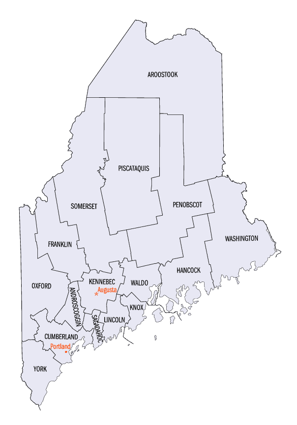
Maine Counties
There are sixteen Counties in Maine. Prior to statehood. The first county to be created was York County, created as York County, Massachusetts by the government of the Massachusetts Bay Colony in 1652. Maine was granted statehood on March 15, 1820 as part of the Missouri Compromise. Nine of the sixteen Counties had their borders defined while Maine was still part of Massachusetts, and hence are older than the state itself. Even after 1820, the exact location of the northern border of Maine was disputed with Britain, until the question was settled and the northern counties took their final, official form by treaty in 1845.Hancock County, Maine
Hancock County Education, Geography, and History
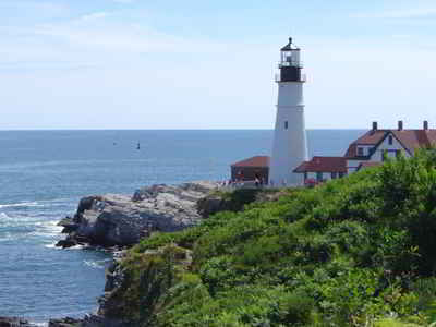
Hancock County is a county located in the state of Maine. Based on the 2010 census, the population was 54,418. Its county seat is Ellsworth. The county was incorporated on June 25, 1789 and named for John Hancock, the first governor of the Commonwealth of Massachusetts.
Etymology - Origin of Hancock County Name
Hancock is named for John Hancock, the Founding Father and president of the convention that produced
the Declaration of Independence.
Demographics:
County QuickFacts: CensusBureau Quick Facts
Hancock County History
History of Hancock County, Maine
From: A Gazetteer of the State of Maine
By Geo. J. Varney
Published by B. B. Russell, 57 Cornhill,
Boston 1886
Hancock County has the most extensive seaboard and more numerous harbors than any other coast of equal extent in
the United States. Its geographical position is mainly between 430 58' and 450 20' north latitude, and between 600
47' and 680 30' west longitude. It is hounded by Washington County on the east, Penobscot and Waldo Counties on the
north and west. From north to south it measures about 85 miles, and in width varies from 6 to 40 miles. The total
area is about 1,632,000 acres, of which 904,528 acres nearly is land, 637,472, ocean, 90,000 pond, and 100,000
island. Nearly half the land is wild. Hancock County contains 1 city, 31 incorporated towns, and 29 inland and
island townships. Within its civic limits are hundreds of islands, one of which, Mount Desert, is the most
conspicuous of any upon the whole Atlantic coast of the United States. Hancock County was organized in 1789, with
Penobscot for its shire town. It then included portions of Penobscot and Waldo counties, and extended northward to
the Canada line. In 1791 a portion was set off and annexed to Lincoln County. In 1827, a portion was taken off for
Waldo. In 1831, and again in 1844 a change was made in the partition line between Hancock and Washington Counties.
In 1858, Greenfleld was set off and annexed to Penobscot.
The first European who made definite mention of the Penobscot bay and river, which wash its western side, was Thevet,
a French explorer, in 1556. Martin Pring amid Captain Weymouth, the English explorers, sailed along its shores in
1603 and 1605, and DeMonts, the Frenchman, explored some portions of the coast in 1604 and 1605. There is a
tradition that Rosier, the historian of Weymouth's expedition, explored Deer Island thoroughfare, making a halt at
the bold promontory in Brooksville, known as Cape Rosier. They found the county occupied by a tribe of Indians, who
with those on Passarnaquoddy waters, were noted for their long journeys in canoes; whence the general name for these
Indians, Etechmins. DeMonts claimed the country in the name of the King of France in the true catholic style,
setting up a cross and calling the country "Acadie."By this name it continued to be known until the capture of
Quebec by general 'Wolfe in 1759. When Weymouth came in 1605, he also claimed the country in the name of his King,
James I. of England. Thus the two leading powers of Europe became adverse claimants of the soil of Hancock County,
and the wars these claims occasioned kept the county an almost unbroken wilderness during the provincial history of
Maine. Indeed, it was not until after the war of the Revolution that the French claim to the territory between the
Penobscot and St. Croix was relinquished. The patent of Acadia granted to DeMonts in 1603 was surrendered two years
later to Madame de Guercheville; who, in 1613, sent over Saussaye with 25 colonists. This lady was a zealous
Catholic, and wished to convert the Indians to that faith. Her colony landed on Mount Desert on May 16, 1613, where
they built a fort, erected a cross, celebrated mass, and named the place "St. Sauveur."The exact locality is now
supposed to be that now known as Ship Harbor, in the town of Tremont. The "Pool"at Somes Sound, is supposed to have
been the place where the Jesuit missionaries, Biard and Masse, located themselves in 1609. This colony was attacked,
captured, and removed from the island in the same season by Captain Argall, of Virginia.
The first English possession was a trading post of the Pilgrims at Pentagoet (Castine) in 1625- 6. This, however,
soon fell into the hands of thr French, and the flag of France floated over it during nearly the whole of the 17th
century. The indications of old French settlements have also been found at Castine, Newbury Neck, Surry, Oak Point,
Trenton, East Lemoine, Crabtree's Neck, Hancock, Butler Point, Franklin, Waukeag Neck and Sullivan. No permanent
English settlements were made until after the fall of Quebec, in 1759.
The first grants of land in the county were six townships, each six miles square, between the rivers Penobscot and
union (then known as the Donaqua), which were granted to David Marsh et als, by the General Court of Massachusetts,
upon conditions, one of which was that they should settle each township with 60 Protestant families within six
years. These grants were No. 1, Bucksport; 2, Orland; 3, Penobscot; ; 4, Sedgewick; 5, Bluehill; and 6, Surry. Six
other townships east of the Union River were granted on the same terms; three of which are in this county, viz.: No.
1, Trenton, granted to Eben Thorndike, et als; 2, Sullivan, to David Bean, et als; and 3, Mount Desert (Island) to
Governor Bernard. The surveys were made by Samuel Livermore; and as there were three of the townships on each side
of the river, it gave rise to the name which the stream now bears. The grantees individually bound themselves in a
penal bond of $50, conditioned to lay out no one of the townships more than six miles in extent on the banks of the
Penobseot, or on the sea-coast; to build sixty dwelling-houses, at least 18 feet square; to fit for tillage 300
acres of land, erect a meeting-house and settle a minister. There were reserved in each township one lot for a
parsonage, another for the first settled minister, a third for Harvard College, and a fourth for the use of Schools;
making 1,200 acres in each township, reserved for public uses.
The King of France, about the year 1688, gave to a French gentlemen named Cadilliac a tract of land in Acadia
embraceing the whole of Mount Desert Island, and a portion of the mainland. This he held till 1713, styling himself
"Lord of Donaqua and Mount Desert."After the war of the Revolution, one M. Gregoire claimed the whole island in
right of his wife, Maria T., a grand-daughter of Cadilliac. Governor Bernard, to whom the island had been granted
lost his title by confiscation, but one half of it had been restored to his son John. In consideration of a request
made by Lafayette in favor of the Gregoire's claim, Massachusetts recognized it as valid; and this is the only
French claim ever sustained to lands in Maine. The heir of Cadilliac therefore received a quit-claim deed for 60,000
acres on the mainland. This inluded the present towns of Trenton and Lemoine, with a part of Sullivan, Ellsworth,
Hancock, Eden and Mount Desert, with the islands in front of the seaboard. A survey of this grant was made by John
Peters in 1789.
In 1786, Massachusetts attempted a lottery sale of fifty townships of land between Penobscot and Passamaquoddy.
These were exempt from taxes for fifteen years. There were 2,720 tickets, and the price was $2 each. Every one was a
prize ticket; the smallest prize being a tract of land a half mile square, and the largest six miles square. Leonard
Jarvis of Surry, was one of the five managers. On the drawing of the lottery, only 437 were found to be sold and
165,280 acres drawn; while 942,112 acres remained unsold. The average price realized by the government for the lands
drawn was about 52 cents per acre. The lots not drawn, and also the greater part of the prize lots were purchased by
'William Bingham, of Philadelphia, a man of great wealth. He died in England in 1803, leaving one son and two
daughters. One of the daughters married Alexander Baring, of London, who subsequently became Lord Ashburton; and as
ambassador to the United States in 1842. framed with the secretary of state, Daniel Webster, the treaty fixing the
eastern and western boundary of Maine, known as the "Webster-Ashburton Treaty."The lottery townships in Hancock
County sold to Mr. Bingham were Nos. 14, 15 and 16, (possibly, also, those "up river"townships sold to him,) each
containing 23,040 acres. The conveyance of these three was made January 28, 1793, by Samuel Phillips, Leonard Jarvis
and John Reed, a committee appointed by the General Court of Massachusetts. In 1792, Barthelemy de Gregoire sold
23,121 acres of his grant to Henry Jackson, of Boston; which in 1796, was purchased by Mr. Bingham, who about the
same time also purchased the residue of the Gregoire grant. Col. John Black, an Englishman by birth, who resided at
Ellsworth for many years, was agent for the Bingham heirs.
Hancock County has one mountain chain, and one group of mountains. The line stretching across Mount Desert Island is
a continuation of the Schoodic system, as are also Mount Desert Island anti the Porcupines. There are thirteen
well-defined peaks on Mount Desert Island, of which Green Mountain, in Eden, is highest, having an altitude of 1,522
feet above the sea. In Dedham is a mountain group, where ten mountains are clustered together, from which the town
has gained the name of the "Switzerland of America."The other elevations sufficiently high to deserve the name of
mountains, are Blue Hill Mountam, in Blue Hill; Bull Hill Mountain, in Eastbrook; Ball and Tunk Mountain, in Number
10, and Lead Mountain, in Number 28. There are narrow defiles of the gorge form at Morgan's Bay, Surry, McHeard's
Landing, in Blue Hill, and near Mason's Mills, in Orland. There is much waste land, known as "Hesths."
The county has three drainage streams: the Penobscot River on the west, the Union in the Middle, and Narraguagus on
the east. The area within the county, tributary to each drainage basin, as computed from Walling's surveys, is Union
River, 516,250 acres; Penobscot River, 252,440 acres; Narraguagus River, 113,510 acres. There are about 300 islands
within the county limits, 270 of which are represented on the county map. The light stations in the county are No.
10, Prospect Harbor, 5th order; 11, Winter Harbor, 5th order; 12, Mount Desert, 3d order; 13, Egg Rock, 4th order;
14, Baker's Island, 4th order; 15, Bear Island, 5th order; 16, Bass Harbor, Head, 5th order; 17, Burnt Coat Harbor,
5th order; 18, Burnt Coat Harbor 4th order; 19, Eggemoggin, 5th order; 20, Saddleback Ledge, 5th order; 22, Deer
Island Thoroughfare, 4th order; 23, Eagle Island Point, 4th order; 24, Pumpkin Island, 5th order; 33, Dice's Head,
4th order; total number, fifteen.
The rock formation of the county is mainly granite, syenite and gneiss. The granite formation appearing at the
surface at Deer Isle continues in a curve through Blue Hill, Sedgewiek, Brooksville, Orland, North Ellsworth, Number
8, Franklin, Sullivan, and ends at Mount Desert. In Eden there is red granite. Most of the granite in Bucksport,
Orland, Dedham, Waltham and Eastbrook is porphyritic, with black mica, like those huge bowiders at Ellsworth Falls.
Within the horse-shoe-like circle of granite which curves from Deer Isle to Mount Desert, the rock is mostly mica
schist, or a micaeous slate. The valley bed of the Union River basin is of this rock. The most abundant variety of
this class of rock consists of alternate layers of mica and quartz. It indicates the presence of gold rather than
coal. At Buck's Harbor, in Brooksville, Green's Landing, in Deer Isle, McHeards, in Blue Hill, at Somes Sound, and
in Sullivan and Franklin, the granite crops out in massive form. Extensive deposits of plastic clay are found at
Castine, Penobscot, Ellsworth and Surry. The whole extent of the county is what is termed a "glaciated surface,"the
soil of which is formed chiefly of the simple geological formation "drift."The course of this drift is shown by the
striae, or scratches upon the ledges, varying from N. 150 W. to N. 150 E. Verd Antique, or green marble, is found at
Deer Isle. Milk-white marble, such as is used for statuary, is said to occur in Eden and Mount Desert.
Minerals and ores are found as follows: Brooksville, iron pyrites; Blue Hill,- fluor spur, galena (lead ore), wolfram
(ore of tin), hydrate of silica, manganese, limestone, phosphate of lime; Bucksport,- limestone, clay slate, quartz;
Castine,- quartz, argillacious slate, plastic clay; Deer Isle,- asbestos, novaculite, limestone. Veins of zinc and
copper occur in No. 7 and in Gouldsboro. Bog iron is found in almost every town. Gold has been found in Bucksport,
Orland and Surry.
An abstract of observations in temperature in Surry shows that the average degree of greatest cold for four years
was 120 20' below zero; and the average of greatest heat for the sanie length of time was 920 Fahrenheit. The mean
summer temperature for the same time was 670 21', and the yearly mean 440 44'. Hancock County has two customs
districts, two ports of entry, six deputy districts, eight ports of delivery, twenty-six hailing ports, and thirteen
United States custom house officials. The county was organized in 1789, being named in honor of John Hancock.
Portions were taken from it in 1816 to form Penobscot, and in 1827, to form Waldo. Ellsworth has been the shire town
since 1837. The valuation of estates in the county in 1870 was $7,554,073. In 1880 it was $7,897,488. The population
in 1870 was 36,495. In 1880 it was 38,131....Hancock
County
Geography: Land and Water
As reported by the Census Bureau, the county has a total area of 2,351 square miles (6,089 km2), of which, 1,588 square miles (4,112 km2) of it is land and 763 square miles (1,977 km2) of it (32.47%) is water.
Neighboring Counties
Bordering counties are as follows:
- Penobscot County, Maine - north
- Washington County, Maine - northeast
- Waldo County, Maine - west
Education


Click Image to Enlarge
