


Click Image to Enlarge
Minnesota Counties
There are eighty-seven Counties in Minnesota. On October 27, 1849 nine large Minnesota Counties were created. Among them were Benton, Dahkotah, Itasca, Ramsey, Mahkahta, Pembina, Wabashaw, Washington, and Wahnata. Of those Benton, Dakota, Itasca, Ramsey, Wabasha, and Washington still exist as their original name. With the creation of Kittson County on March 9, 1878, Pembina County no longer existed. When Minnesota was organized as a state, 57 of the present 87 Counties were established. The last county to be created was Lake of the Woods County in 1923Olmsted County, Minnesota
Olmsted County Education, Geography, and History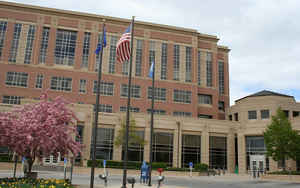
Olmsted County is a county located in the state of Minnesota. Based on the 2010 census, the population was 144,248. Its county seat and
largest city is Rochester. The county was founded in 1855 and named for David Olmsted, a member of the first territorial council and the first
mayor of St. Paul.
Olmsted County is part of the Rochester, MN Metropolitan Statistical Area.
Etymology - Origin of Olmsted County Name
Named for David Olmsted, first mayor of St. Paul, 1854; member of the council of the first territorial legislature, 1849 and 1850.
Demographics:
County QuickFacts: CensusBureau Quick Facts
Olmsted County History
This county, established February 20, 1855 from Fillmore, Wabasha, and Rice Counties, was named in honor of David Olmsted, first mayor of
St. Paul, in 1854, who in 1855 removed to Winona, in the county of that name, adjoining Olmsted county. He was born in Fairfax, Vt, May 5,
1822; came to the Northwest, first to the Wisconsin lead mining region, in 1838; was a pioneer settler of Monona, Iowa, in 1840; engaged in
trading with the Indians at Fort Atkinson, Iowa, in 1844; was a member of the convention which framed the state constitution of Iowa, in 1846;
came in 1848 to
Long Prairie, Minn., when the Winnebago Indians were transferred there, and established a trading post which he continued several years. He
was a charter member of the Minnesota Historical Society, and a member of the council of the first territorial legislature, 1849 and 1850,
being its first president. In 1853, having removed to St. Paul, he became proprietor and editor of the Minnesota Democrat, which under his
management began its issue as a daily newspaper in May, 1854. After his removal to Winona, ill health compelled him, in 1857, to give up
business, and he then returned to his old home in Vermont, where he died February 2, 1861.
Another prominent citizen of this name, but of another family, with slightly different spelling, for whom, however, some have supposed this
county to be named, was S. Baldwin Olmstead, a farmer and contractor, of Belle Prairie and Fort Ripley, who was a member of the territorial
council in 1854 and 1855, when this county was created, having been president of the council in the former year. He was born in Otsego county,
N. Y., in 1810; came to the Northwest in early manhood, and resided in Iowa and Minnesota; was engaged with government contracts about Fort
Ripley for a time; removed to Texas at the close of the civil war, and settled on a farm in Burnett county, where he died, January 27, 1878.
Source: MINNESOTA GEOGRAPHIC NAMES Their Origin and Historic Significance
by Warren Upham, Archaeologist of the Society
Published by the Minnesota Historical Society
Saint Paul, 1920
Geography: Land and Water
As reported by the Census Bureau, the county has a total area of 655 square miles (1,700 km2), of which 653 square miles (1,690 km2) is
land and 1.5 square miles (3.9 km2) (0.2%) is water.
It is one of four counties in the state with no natural lakes.
Neighboring Counties
Bordering counties are as follows:
- Wabasha County (north)
- Winona County (east)
- Fillmore County (south)
- Mower County (southwest)
- Dodge County (west)
- Goodhue County (northwest)
Education


Click Image to Enlarge
