Minnesota Counties
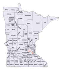
There are eighty-seven Counties in Minnesota. On October 27, 1849 nine large Minnesota Counties were created. Among them were Benton, Dahkotah, Itasca, Ramsey, Mahkahta, Pembina, Wabashaw, Washington, and Wahnata. Of those Benton, Dakota, Itasca, Ramsey, Wabasha, and Washington still exist as their original name. With the creation of Kittson County on March 9, 1878, Pembina County no longer existed. When Minnesota was organized as a state, 57 of the present 87 Counties were established. The last county to be created was Lake of the Woods County in 1923Minnesota Counties: History and Information
Find a brief history of Minnesota Counties
That part of present day Minnesota lying between the Mississippi and the St. Croix Rivers was in the original Northwest Territory and part of the Wisconsin Territory. The settlement, which is now Stillwater, was once part of St. Croix County, Wisconsin. When Minnesota became a territory in 1849 its territorial governor, Alexander Ramsey, proclaimed that the same laws as those existing in Wisconsin would govern the new Minnesota Territory. This, combined with the fact that much of the migration to Minnesota came through Wisconsin, caused the development of both strong county and town forms of government as had been the case in Wisconsin, New York and Michigan.
The first Minnesota counties were Benton, Isanti,
Ramsey Wabasha, and Washington established on October 27, 1849. Three other counties, Mankahto, Pembina and Wahnata were created by Laws 1849 but there
is no historical evidence to indicate that they were ever organized - or abolished. Fifty-seven of the present 87 counties were established during
the territorial period that ended in 1857. Lake of the Woods County was the last one established in Minnesota. It was created by popular vote from
territory that had been part of Beltrami County.
| Find a brief history of Minnesota Counties | ||||
|---|---|---|---|---|
| County | 2000 Population |
Square Miles |
County Seat | Created |
| Aitkin County | 15,301 | 1,819 | Aitkin | 1857 |
| Anoka County | 298,084 | 424 | Anoka | 1857 |
| Becker County | 30,000 | 1,310 | Detroit Lakes | 1858 |
| Beltrami County | 39,650 | 2,505 | Bemidji | 1866 |
| Benton County | 34,226 | 408 | Foley | 1849 |
| Big Stone County | 5,820 | 497 | Ortonville | 1862 |
| Blue Earth County | 55,941 | 752 | Mankato | 1853 |
| Brown County | 26,911 | 611 | New Ulm | 1855 |
| Carlton County | 31,671 | 860 | Carlton | 1857 |
| Carver County | 70,205 | 357 | Chaska | 1855 |
| Cass County | 27,150 | 2,018 | Walker | 1851 |
| Chippewa County | 13,088 | 583 | Montevideo | 1870 |
| Chisago County | 41,101 | 418 | Center City | 1851 |
| Clay County | 51,229 | 1,045 | Moorhead | 1862 |
| Clearwater County | 8,423 | 995 | Bagley | 1902 |
| Cook County | 5,168 | 1,451 | Grand Marais | 1874 |
| Cottonwood County | 12,167 | 640 | Windom | 1857 |
| Crow Wing County | 55,099 | 997 | Brainerd | 1857 |
| Dakota County | 355,904 | 570 | Hastings | 1849 |
| Dodge County | 17,731 | 440 | Mantorville | 1855 |
| Douglas County | 32,821 | 634 | Alexandria | 1858 |
| Faribault County | 16,181 | 714 | Blue Earth | 1855 |
| Fillmore County | 21,122 | 861 | Preston | 1853 |
| Freeborn County | 32,584 | 708 | Albert Lea | 1855 |
| Goodhue County | 44,127 | 759 | Red Wing | 1853 |
| Grant County | 6,289 | 546 | Elbow Lake | 1868 |
| Hennepin County | 1,116,200 | 557 | Minneapolis | 1852 |
| Houston County | 19,718 | 558 | Caledonia | 1854 |
| Hubbard County | 18,376 | 923 | Park Rapids | 1883 |
| Isanti County | 31,287 | 439 | Cambridge | 1857 |
| Itasca County | 43,992 | 2,665 | Grand Rapids | 1850 |
| Jackson County | 11,268 | 702 | Jackson | 1857 |
| Kanabec County | 14,996 | 525 | Mora | 1858 |
| Kandiyohi County | 41,203 | 796 | Willmar | 1858 |
| Kittson County | 5,285 | 1,097 | Hallock | 1879 |
| Koochiching County | 14,355 | 3,102 | International Falls | 1906 |
| Lac Qui Parle County | 8,067 | 765 | Madison | 1863 |
| Lake County | 11,058 | 2,099 | Two Harbors | 1856 |
| Lake Of The Woods County | 4,522 | 1,297 | Baudette | 1923 |
| Le Sueur County | 25,426 | 448 | Le Center | 1853 |
| Lincoln County | 6,429 | 537 | Ivanhoe | 1873 |
| Lyon County | 25,425 | 714 | Marshall | 1871 |
| Mahnomen County | 5,190 | 556 | Mahnomen | 1906 |
| Marshall County | 10,155 | 1,772 | Warren | 1879 |
| Martin County | 21,802 | 709 | Fairmont | 1857 |
| McLeod County | 34,898 | 492 | Glencoe | 1856 |
| Meeker County | 22,644 | 609 | Litchfield | 1856 |
| Mille Lacs County | 22,330 | 574 | Milaca | 1857 |
| Morrison County | 31,712 | 1,124 | Little Falls | 1856 |
| Mower County | 38,603 | 712 | Austin | 1855 |
| Murray County | 9,165 | 704 | Slayton | 1875 |
| Nicollet County | 29,771 | 452 | Saint Peter | 1853 |
| Nobles County | 20,832 | 716 | Worthington | 1857 |
| Norman County | 7,442 | 876 | Ada | 1881 |
| Olmsted County | 124,277 | 653 | Rochester | 1855 |
| Otter Tail County | 57,159 | 1,980 | Fergus Falls | 1858 |
| Pennington County | 13,584 | 617 | Thief River Falls | 1910 |
| Pine County | 26,530 | 1,411 | Pine City | 1856 |
| Pipestone County | 9,895 | 466 | Pipestone | 1857 |
| Polk County | 31,369 | 1,970 | Crookston | 1858 |
| Pope County | 11,236 | 670 | Glenwood | 1862 |
| Ramsey County | 511,035 | 156 | Saint Paul | 1849 |
| Red Lake County | 4,299 | 432 | Red Lake Falls | 1896 |
| Redwood County | 16,815 | 880 | Redwood Falls | 1862 |
| Renville County | 17,154 | 983 | Olivia | 1855 |
| Rice County | 56,665 | 498 | Faribault | 1853 |
| Rock County | 9,721 | 483 | Luverne | 1857 |
| Roseau County | 16,338 | 1,663 | Roseau | 1894 |
| Scott County | 89,498 | 357 | Shakopee | 1853 |
| Sherburne County | 64,417 | 437 | Elk River | 1856 |
| Sibley County | 15,356 | 589 | Gaylord | 1853 |
| St. Louis County | 200,528 | 6,226 | Duluth | 1855 |
| Stearns County | 133,166 | 1,345 | Saint Cloud | 1855 |
| Steele County | 33,680 | 430 | Owatonna | 1855 |
| Stevens County | 10,053 | 562 | Morris | 1862 |
| Swift County | 11,956 | 744 | Benson | 1870 |
| Todd County | 24,426 | 942 | Long Prairie | 1855 |
| Traverse County | 4,134 | 574 | Wheaton | 1862 |
| Wabasha County | 21,610 | 525 | Wabasha | 1849 |
| Wadena County | 13,713 | 536 | Wadena | 1858 |
| Waseca County | 19,526 | 423 | Waseca | 1857 |
| Washington County | 201,130 | 392 | Stillwater | 1849 |
| Watonwan County | 11,876 | 434 | Saint James | 1860 |
| Wilkin County | 7,138 | 752 | Breckenridge | 1858 |
| Winona County | 49,985 | 626 | Winona | 1854 |
| Wright County | 89,986 | 661 | Buffalo | 1855 |
| Yellow Medicine County | 11,080 | 758 | Granite Falls | 1871 |


