


Click Image to Enlarge
Mississippi Counties
There are eighty counties in Mississippi. Two original counties were Adams County and Jefferson County (formerly Pickering) established in 1799Monroe County, Mississippi
Monroe County Education, Geography, and History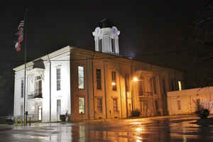
Monroe County is a county on the northeast border of the state of Mississippi next to Alabama. Based on the 2010 census, the population was 36,989. Its county seat is Aberdeen.
Etymology - Origin of Monroe County Name
Monroe is named for US President James Monroe.
Demographics:
County QuickFacts: CensusBureau Quick Facts
Monroe County History
Monroe was originally embraced within the Chickasaw Indian territory, and by the treaty of Chickasaw Council House concluded September 20, 1816, that nation ceded to the United States 408,000 acres on their eastern or Creek frontier. This large tract lay upon the eastern tributaries of the upper Tombigbee River and comprised the original "county of Monroe."The Creek claims to these lands were surrendered by the treaty of Fort Jackson. It was attached to the State of Alabama until the winter of 1820, when the boundary was determined by actual survey, and on February 9, 1821, the legislature of Mississippi recognized it as within the limits of the State and approved a law entitled, "An act to form a county east of the Tombigbee River, and for other purposes,"which defined its limits as follows:
"All the tract of country lying on the east side of the Tombigbee River... beginning on the east side of said river, where the eastern boundary line of the State crosses the same; thence northwardly with said boundary line, to the Chickasaw boundary; thence with said boundary line westwardly to the Tombigbee River; thence with the meanders of said river to the beginning."The act of February 9, 1836, which organized the Chickasaw cession of 1832 into counties, extended the limits of Monroe and defined them as follows: "Beginning at the point one mile due north of the point where the line between townships 11 and 12 intersects the eastern boundary line of the State, and running thence due west to the line between ranges 5 and 6 east; thence south with the said range line, to the northern boundary of Oktibbeha County; and thence due east to the mouth of the Buttahatchy River; thence according to the present boundaries between the said county of Monroe and the county of Lowndes, to the eastern boundary line of the State, and thence along the said eastern boundary line to the beginning."
Since that time Monroe County has formed part of the State of Mississippi, though it was long separated from the
older counties in the southern part, and from the counties in the western part, erected out of the "New Purchase,"
by the remaining territory of the Choctaws. It was connected with them by a public road through the Chickasaw and
Choctaw nations long known as the Natchez Trace. Lowndes County and a part of Clay County were embraced within the
old county of Monroe.
The last contribution of Monroe County from its territory was in 1872, when it relinquished some of its southwestern
sections to the new county of Clay. It received its name from President James Monroe.
Its early county seat was at Hamilton, in the southern part of the county, one mile east of the Tombigbee River. The
present town of Hamilton lies three miles to the northeast. Later, in 1830, the seat was moved to Athens, a little
north of Aberdeen on the eastern side of the Tombigbee, where it remained until 1849. Cotton Gin Port was another
old settlement on the Tombigbee about thirteen miles north of Aberdeen. The present county seat is Aberdeen. Among
its first settlers were the Rowlands and Sykes who settled in the village when it was still close to the river.
Colonel Rowland later removed to a plantation close by- the two families pioneered together from Virginia to the
State of Mississippi.
Geography: Land and Water
As reported by the Census Bureau, the county has a total area of 772 square miles (2,000 km2), of which, 764
square miles (1,979 km2) of it is land and 8 square miles (20 km2) of it (1.02%) is water.
Neighboring Counties
Bordering counties are as follows:
- Lowndes County (south)
- Clay County (southwest)
- Chickasaw County (west)
- Lee County (northwest)
- Itawamba County (north)
- Lamar County, Alabama (east)
Education


Click Image to Enlarge
