


Mississippi Geography: The Land
Geography and Landforms of Mississippi
 Find an overview of Mississippi geography,
topography, geographic land regions, land areas, and major rivers.
Find an overview of Mississippi geography,
topography, geographic land regions, land areas, and major rivers.
Access Mississippi almanac, furnishing more details on the state geography, geographical and land regions, climate and weather, elevation, land areas, bordering states, and other statistical data.
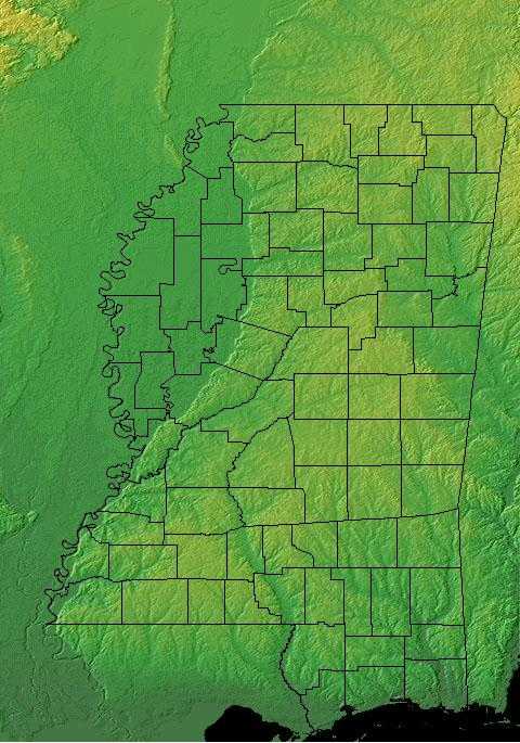
Mississippi is bordered by Tennessee on the north and the Gulf of Mexico on the south. On the east, Mississippi borders Alabama, and on the west, Arkansas and Louisiana. The highest point in Mississippi is Woodall Mountain, although it can hardly be called a mountain, being only 806 feet above sea level. The major rivers of the state are the Mississippi River, the Big Black River, the Pearl River, and the Yazoo River.
There is a low fertile delta of land between the Yazoo and the Mississippi Rivers, but much of the state is composed of sandy coastal terraces, pine woods, and prairie. Mississippi is divided into four geographic regions.
Mississippi Highest, Lowest, & Mean Elevations |
|
|---|---|
| Mean Elevation | 300 ft. |
| Highest Point | Woodall Mountain 806 ft. |
| Lowest Point | Gulf of Mexico Sea level |
Mississippi Land Area (Square Miles) |
|
| Geographic Center | In Leake County, 9 mi. WNW of Carthage Longitude: 89° 43.0'W Latitude: 32° 48.9'N |
| Total Area | 48,430.19 sq. mi. 32nd |
| Land Area | 46,906.96 sq. mi. 96.86% |
| Water Area | 1,523.24 sq. mi. 3.14% |
| Forested Land Area | 61.9% |
| Dimensions (Length - Width) |
340 miles - 170 miles |
Mississippi: Physiographic Regions
These lowlands can be divided into two regions:
- Mississippi Alluvial Plain
- Gulf Coastal Plain
East Gulf Coastal Plain
The East Gulf Coastal Plain extends from the Florida Parishes of Louisiana over most of Mississippi, some of western Tennessee and Kentucky, the southwestern 2/3 of Alabama, and the western panhandle of Florida. Its southern boundary is the Gulf of Mexico and its western boundary the drop into the Mississippi Alluvial Valley. On the north it extends to the highlands of the Interior Low Plateaus and southern Appalachians. To the east, there is an arbitrary break with the South Atlantic Coastal Plain at the Alabama-Georgia border south through Florida along the Apalachicola River. The flat to rolling topography is broken by numerous streams and river bottoms. Uplands are dominated by pine, originally longleaf and slash in the south and shortleaf mixed with hardwoods in the north. These are fire-maintained systems that give way to loblolly pine and hardwoods in damper areas and bottomland hardwood forest in extensive lowland drainages.
Mississippi Alluvial Valley
This area includes the floodplain of the Mississippi River that cuts into the Gulf Coastal Plain, extending north to and including the delta at the confluence of the Mississippi and Ohio Rivers and south toward the Gulf of Mexico. The Alluvial Valley includes most of eastern Louisiana, eastern Arkansas, northwest Mississippi, small portions of west Tennessee and Kentucky, the bootheel of Missouri, and the Cache River lowlands of Illinois. Nonforested marsh in southern portions of the floodplain is included in the Coastal Prairie physiographic area. Water shaped this land. The ridges and swales, levees, oxbows, and terraces of the Valley all resulted from meanderings and floods of the Mississippi River. Small changes in elevation determine how wet a site is, the plant community that grows there, and habitat conditions for birds.
Mississippi Landscape and Landforms:
The Gulf Coast
- The Coastal Terrace
- The Barrier Islands
The Southern Wooded Prairies
- The Pine Belt
- The Central Prairie
The Delta
- The Mississippi-Yazoo River Basin
- The Loess Bluffs
The Northern Highlands
- The Red Clay Hills
- The Flatwoods
- The Pontotoc Ridge
- The Black Prairie
- The Northeastern Hills

