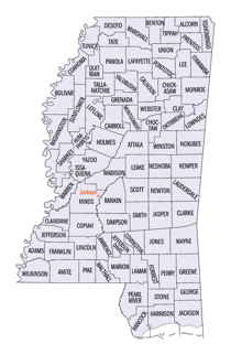
Wayne County, Mississippi
Wayne County Education, Geography, and History
Wayne County is a county located in the state of Mississippi. Based on the 2010 census, the population was 20,747. Its county seat is Waynesboro. The county is named for General Anthony Wayne.
Etymology - Origin of Wayne County Name
Wayne is named for General "Mad" Anthony Wayne. Anthony Wayne (January 1, 1745-December 15, 1796) was a United States Army general and statesman. Wayne adopted a military career at the outset of the American Revolutionary War, where his military exploits and fiery personality quickly earned him a promotion to the rank of brigadier general and the sobriquet of "Mad Anthony".
Demographics:
County QuickFacts: CensusBureau Quick Facts
Wayne County History
Wayne County received its name in honor of the Revolutionary hero, General Anthony Wayne, as did its county seat, Waynesboro. It was created by act of the General Assembly of Mississippi territory, December 21, 1809, and embraced the western, or Mississippi portion, of the old county of Washington, established in 1800 by proclamation of Governor Sargent and perpetuated in the present county of that name in Alabama. The act of 1809 which created Wayne County recites that Washington shall be divided as follows:
"beginning on the line of demarcation, where the trading road leading from the Choctaw nation to Mobile crosses the same, thence along said trading road to the present Choctaw boundary line, thence along said boundary line to Pearl River, thence down the same to the line of demarcation, and with the same to the place of beginning, all to be called the county of Wayne";
Out of this vast region have been subsequently carved the counties of Greene, Covington, Jones, Perry, Lamar, and those portions of Lawrence and Marion lying east of the Pearl River. Finally, the act of December 23, 1833, which divided the Choctaw cession of 1830 into counties, declared that
"all the territory south of Clarke County, known as the Higoowanne reserve, be, and the same is attached to, and shall constitute a part of Wayne County."
The Creek Indians, during the War of 1812, were a constant source of menace to the early settlers of Wayne, which
fact led to the erection of Patton's Fort at Winchester, and Roger's Fort, about seven miles north of that place.
The old ditches of Patton's Fort may still be readily traced. The old town of Winchester has quite disappeared, the
last of its structures to crumble being the court house built in 1822. The name survives in the town of the same
name on the Mobile & Ohio railroad near the old site. It is said that the lack of adequate hotel accommodations
during the terms of court, led to the removal of the county seat to Waynesboro a few miles to the north of the
railway. It is an interesting fact that in these earliest settlements on Buckatunna Creek and at Winchester, and in
the first school established about 1812, the Gaelic language was exclusively spoken and remained the vernacular
until the early '20s, when the influx of English speaking settlers caused its disuse.
Geography: Land and Water
As reported by the Census Bureau, the county has a total area of 814 square miles (2,107 km2), of which, 810
square miles (2,099 km2) of it is land and 3 square miles (8 km2) of it (0.39%) is water.
Neighboring Counties
Bordering counties are as follows:
- Clarke County (north)
- Choctaw County, Alabama (northeast)
- Washington County, Alabama (southeast)
- Greene County (south)
- Perry County (southwest)
- Jones County (west)
- Jasper County (northwest)
Cities and Towns:
Education
County Resources:
Enter County Resources and Information Here


