


Click Image to Enlarge
Virginia Counties
The Commonwealth of Virginia is divided into ninety-five counties and thirty-eight independent cities, which are considered county-equivalents for census purposes.Russell County, Virginia
Russell County Education, Geography, and History
Russell County is a county located in the Commonwealth of Virginia. Based on the 2010 census, the population was 28,897. Its county seat is Lebanon
Etymology - Origin of Russell County Name
Russell is named for Virginia state legislator William Russell.
Demographics:
County QuickFacts: CensusBureau Quick Facts
Russell County History
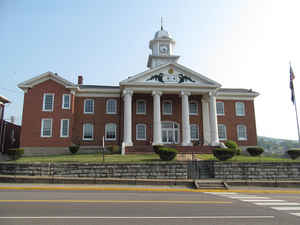
On January 2, 1786, Russell County was established from a section of Washington County. L.P. Summers, a Washington County historian later wrote, "Washington County lost a great extent of country and many valuable citizens when Russell County was formed." The county was named for Culpeper County native Colonel William Russell. The first court met in May 1786 in the Castle's Woods settlement (present-day Castlewood) in the house of William Robinson. Later, a new place was built to house the County Seat. The structure used as a courthouse still stands, and is referred to as "The Old Courthouse." The present Courthouse, located in Lebanon, has been in use since 1874.
Russell County, Virginia formed from Washington County. [Virginia Counties: Those Resulting from Virginia Legislation, by Morgan Poitiaux Robinson, originally published as Bulletin of the Virginia State Library, Volume 9, January, April, July 1916, reprinted 1992 by Genealogical Publishing Co., Inc., Baltimore, MD.]
Russell County was named for William Russell, a Clinch Valley pioneer and the member of the House of Delegates who introduced the legislation forming the county from Washington County in 1786. On January 2, 1786, Russell County was established from a section of Washington County. Its area is 483 square miles, and the county seat is Lebanon.
Geography: Land and Water
As reported by the Census Bureau, the county has a total area of 477 square miles (1,235 km2), of which, 475
square miles (1,229 km2) of it is land and 2 square miles (5 km2) of it (0.44%) is water.
Neighboring Counties
Bordering counties are as follows:
- Buchanan County, VA to the north
- Dickenson County, VA to the northwest
- Scott County, VA to the west
- Smyth County, VA to the east
- Tazewell County, VA to the northeast
- Washington County, VA to the south
- Wise County, VA to the west
Education


Click Image to Enlarge
