


Click Image to Enlarge
Georgia Counties
Georgia is divided into one hundred and fifty-nine counties. The original eight counties of the State of Georgia were Burke, Camden, Chatham, Effingham, Glynn, Liberty, Richmond and Wilkes all created on February 5, 1777. The last new county to be established in Georgia was Peach County, established in 1924.Carroll County, Georgia
Carroll County Education, Geography, and History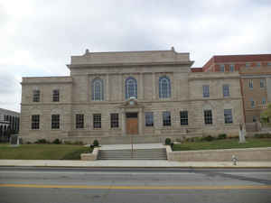
Carroll County is a county located in the State of Georgia. Based on the 2010 census, its population was about 110,527. Carroll County was created on June 9, 1825 from lands ceded by the Creek Indians in 1825 in the Treaty of Indian Springs. The county seat is the town of Carrollton. The county is named in honor of Charles Carroll (1737-1832), the last surviving signer of the Declaration of Independence.
Carroll County is included in the Atlanta-Sandy Springs-Roswell, GA Metropolitan Statistical Area. It is located just east of the boundary with Alabama
Etymology - Origin of Carroll County Name
Georgia's 66th county was named for Charles Carroll of Maryland, at that time the last surviving signer of the Declaration of Independence. (Carroll died in 1832 at the age of 95.)
Demographics:
County QuickFacts: CensusBureau Quick Facts
Carroll County History
Georgia's 66th county was named for Charles Carroll of Maryland, at that
time the last surviving signer of the Declaration of Independence. (Carroll
died in 1832 at the age of 95.)
Carrollton, the county seat, was named for Charles Carroll's Maryland plantation.
Points of Interest
The Italian Renaissance Revival county courthouse, built in 1928 and enlarged
in 1976, is on the National Register of Historic Places.
On the Chattahoochee River near Whitesburg, the county operates an unusual
park known as the McIntosh Reserve. This 480-acre passive recreation site
was once the plantation of Creek Indian Chief William McIntosh, who was murdered
in 1825 by a group of Upper Creek Indians angry at his transfer of Creek lands
to white settlers.
John Tanner State Park is a major recreational attraction of the county. This
park includes nature trails, canoeing and paddle boating, fishing and camping.
Notable Citizens
Famous actress Susan Hayward lived in Carroll County during the height of her career and is now buried there.
Geography: Land and Water
As reported by the Census Bureau, the county has a total area of 504 square miles (1,310 km2), of which 499 square miles (1,290 km2) is land and 4.8 square miles (12 km2) (0.9%) is water.
Carroll county is located in northwest Georgia. The county is in the Tallapoosa River basin and the Chattahoochee River basin.
Neighboring Counties
Bordering counties are as follows:
- Northeast: Paulding County; Douglas County; Fulton County
- Southeast: Coweta County
- South: Heard County
- Southwest: Randolph County, Ala.
- West: Cleburne County, Ala.
- Northwest: Haralson County
Education
Carroll County is home to the State University of West Georgia, a public four-year institution.


Click Image to Enlarge
