


Click Image to Enlarge
Georgia Counties
Georgia is divided into one hundred and fifty-nine counties. The original eight counties of the State of Georgia were Burke, Camden, Chatham, Effingham, Glynn, Liberty, Richmond and Wilkes all created on February 5, 1777. The last new county to be established in Georgia was Peach County, established in 1924.Early County, Georgia
Early County Education, Geography, and History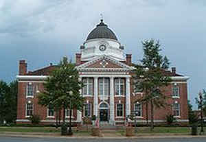
Early County is a county located in the southwest of the state of Georgia. Based on the 2010 census, the population was 11,008. Early county was created by European Americans on December 15, 1818. The county seat is Blakely, home of the Early County Courthouse. The county is named for Peter Early, Governor of Georgia from 1813 to 1815, Superior Court Judge, and member of Congress.
Etymology - Origin of Early County Name
Georgia's 41st county was named for Peter Early, Governor of Georgia from 1813 to 1815, Superior Court Judge, and member of Congress.
Demographics:
County QuickFacts: CensusBureau Quick Facts
Early County History
Early County was created from land obtained from the Creek Indians. The counties of Calhoun, Clay, Decatur, Dougherty, Grady, Miller, Mitchell, and Seminole were all created from territory originally belonging to Early County.
Georgia's 41st county was named for Peter Early, Governor of Georgia from 1813 to 1815, Superior Court Judge, and member of Congress. Blakely, the county seat, was named for Captain Johnson Blakely, a North Carolinian lost at sea during the War of 1812
Points of Interest
Kolomoki Mounds State Park, located in the north central part of Early County, contains a row of mounds of Native American origin dating to around the year 800. One mound believed to have been a temple base is the largest in the United States. The museum interprets seven mounds built during the
12th and 13th centuries by Swift Creek and Weeden Island Indians. The park also features a beautiful lake for canoeing and swimming, primitive and RV camping, and a nature trails for hiking and bird watching.
The southernmost covered bridge in the United States, Coheelee Creek Bridge, is located in the western part of the county. Built for $490 in 1891, the bridge stretches 96 feet across the Coheelee Creek. The bridge was placed on the National Register of Historic Places in 1976 and completely restored
in 1984. The area surrounding the bridge is now operated as a historic park, offering creek side trails with native plants and picnic facilities.
As with many counties in Southwest Georgia, peanut farming is a vital component of Early County's economy. Early County is the largest peanut quota holding county in the nation. In recognition of this crop's importance, a statue of a peanut was erected on the square in Blakely in 1954.
Erected in 1861, the only known Confederate Flag Pole is the last remaining wooden Confederate flag pole standing. Located on the north side grounds of the Early County Courthouse in downtown Blakely. This historic landmark is the only one of its kind in the Southeastern area.
Geography: Land and Water
As reported by the Census Bureau, the county has a total area of 516 square miles (1,340 km2), of which 513 square miles (1,330 km2) is land and 3.8 square miles (9.8 km2) (0.7%) is water.
Early county is located in southwest Georgia. The county is in the Flint River basin and the Chattahoochee River basin. The county is bordered on the west by the Chattahoochee River..
Neighboring Counties
Bordering counties are as follows:
- North: Clay County
- Northeast: Calhoun County
- East: Baker County
- Southeast: Miller County
- South: Seminole County
- Southwest: Houston County, Ala.
- Northwest: Henry County, Ala.
Education


Click Image to Enlarge
