


Click Image to Enlarge
Georgia Counties
Georgia is divided into one hundred and fifty-nine counties. The original eight counties of the State of Georgia were Burke, Camden, Chatham, Effingham, Glynn, Liberty, Richmond and Wilkes all created on February 5, 1777. The last new county to be established in Georgia was Peach County, established in 1924.Glascock County, Georgia
Glascock County Education, Geography, and History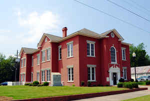
Glascock County is a county located in the state of Georgia. Based on the 2010 census, the population was 3,082. The county was created on December 19, 1857. The county seat is Gibson. Glascock county is named after Brigadier General Thomas Glascock, lawyer, member of Congress and an officer in the State Militia.
Etymology - Origin of Glascock County Name
Glascock County was named after Brigadier General Thomas Glascock, a member of Congress, lawyer, and an officer in the State Militia.
Demographics:
County QuickFacts: CensusBureau Quick Facts
Glascock County History
Glascock County is located in the eastern part of Georgia about 35 miles southwest of Augusta. It has an area span of 144 square miles and population of just under 2,600.
It was formed on December 19, 1857 following the introduction of a bill into the State Government by Wiley W. Kitchens, a representative and resident of the southern part of the county. A small part of Jefferson County was added to Glascock County in 1860.
Carters Lake provides a major recreational area in the county. Carters Lake is formed from the Coosawatee River, which is formed from the Cartecay and Ellijay Rivers. The rivers were formerly used for timber operations in the area.
The Glascock County Courthouse is listed on the National Register of Historic Places. Other interesting historic sites include the Kelley House (1880), the Victorian Peebles Home (1890), and the James Kelley/Sherman Harris place (1828).
Gibson was named for Judge William Gibson, a former Colonel in the Confederate Army, who donated $500 for the first public building (the courthouse) in Glascock County.
Points of Interest
Within Hamburg State Park is an industrial museum located in a 1920 water-turbine powered gin and milling complex.
The Ogeechee River, which forms a portion of the western boundary of the county, provides a wide variety of recreational activities. Rocky Comfort Creek also provides fishing and camping.
The county has one kaolin mining and processing plant. Farming and forestry are the dominant sectors of the economy.
Geography: Land and Water
As reported by the Census Bureau, the county has a total area of 144 square miles (370 km2), of which 144 square miles (370 km2) is land and 0.7 square miles (1.8 km2) (0.5%) is water.
Glascock county is located close to the center of Georgia. The county is the fourth-smallest county in Georgia by area. Glascock is in the Ogeechee River basin and the Savannah River basin.
Neighboring Counties
Bordering counties are as follows:
- Southeast: Jefferson County
- Southwest: Washington County
- West: Hancock County
- Northwest: Warren County
Education


Click Image to Enlarge
