


Click Image to Enlarge
Georgia Counties
Georgia is divided into one hundred and fifty-nine counties. The original eight counties of the State of Georgia were Burke, Camden, Chatham, Effingham, Glynn, Liberty, Richmond and Wilkes all created on February 5, 1777. The last new county to be established in Georgia was Peach County, established in 1924.Johnson County, Georgia
Johnson County Education, Geography, and History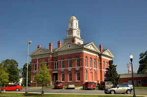
Johnson County is a county located in the state of Georgia. Based on the 2010 census, the
population was 9,980. Johnson County was
created on December 11, 1858. The county
seat is
Wrightsville. The county is named in honor of
Herschel Vespasian Johnson (1812-1880), a U.S. Senator and the Governor
of Georgia.
Johnson County is part of the Dublin, GA Micropolitan Statistical Area.
Etymology - Origin of Johnson County Name
Johnson County was named for Georgia governor, senator, and unsuccessful US vice-presidential candidate, Hershel V. Johnson.
Demographics:
County QuickFacts: CensusBureau Quick Facts
Johnson County History
Johnson County, the 129th county formed in Georgia, was created in 1858. Originally part of Emanuel, Laurens and Washington counties, Johnson County was named for Georgia governor, senator, and unsuccessful US vice-presidential candidate, Hershel V. Johnson.
The county seat of Wrightsville, which was named for James B. Wright, a member of the committee that selected the site for the town. The other community is Kite, named for Shaderick Kight who donated the land for the town. He requested the simpler spelling of his name to facilitate mail delivery.
The Johnson County Courthouse, built in 1895, is listed on the National Register of Historic Places. It is built of masonry in the Romanesque Revival/Colonial Revival style. It was renovated in 1940 by the Works Progress Administration.
The Grice Inn, also listed on the National Register, was built in 1905 by John Grice as a family home and inn. It served as the town's social center for many years.
Points of Interest
The Kite Museum, in the former Masonic Lodge (1890), relates the history of the Kite community. Originally the second floor was used by the Masons and the first floor was used as the community center.
Geography: Land and Water
As reported by the Census Bureau, the county has a total area of 307 square miles (800 km2), of which 303 square miles (780 km2) is land and 3.6 square miles (9.3 km2) (1.2%) is water.
Johnson county is located close to the center of Georgia. The county is in the Altamaha River basin and the Oconee River basin.
Neighboring Counties
Bordering counties are as follows:
- Northeast: Jefferson County
- Southeast: Emanuel County; Treutlen County
- Southwest: Laurens County
- West: Wilkinson County
- Northwest: Washington County
Education


Click Image to Enlarge
