


Click Image to Enlarge
Georgia Counties
Georgia is divided into one hundred and fifty-nine counties. The original eight counties of the State of Georgia were Burke, Camden, Chatham, Effingham, Glynn, Liberty, Richmond and Wilkes all created on February 5, 1777. The last new county to be established in Georgia was Peach County, established in 1924.Jones County, Georgia
Jones County Education, Geography, and History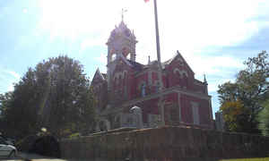
Jones County is a county located in the state of Georgia. Based on the 2010 census, the population was 28,669. The county was created on December 10, 1807. The county seat is Gray. Jones county is named after US Representative James Jones.
Etymology - Origin of Jones County Name
The county is named for James Jones, an early Georgia Congressman and a member of the State Constitutional Convention of 1798.
Demographics:
County QuickFacts: CensusBureau Quick Facts
Jones County History
Jones County, the 30th county formed in Georgia, was created in 1807. Originally part of Baldwin County, it was named for James Jones, an early Georgia Congressman and a member of the State Constitutional Convention of 1798.
Clinton, established in 1809, was a center for New England settlers whose influence is reflected in the architecture of the town. The houses stand close to the streets which fan out from a central square. At one time, this was the fourth largest city in the state. Clinton was one of 187 inactive
municipalities to lose its charter in 1995, as a result of a 1993 Act of the General Assembly.
The town of Gray was originally known as James in honor of the man whose land it was on, James H. Blount. It was changed to Gray to honor James Madison Gray, a major financier of the Confederacy.
Points of Interest
The Ocmulgee River, the restored Jarrell Plantation, and the Piedmont National Wildlife Refuge are located in the county. Jarrell Plantation is a State Historic Site within the Piedmont National Wildlife Refuge.
Geography: Land and Water
As reported by the Census Bureau, the county has a total area of 395 square miles (1,020 km2), of which 394 square miles (1,020 km2) is land and 1.5 square miles (3.9 km2) (0.4%) is water.
Jones county is located close to the center of Georgia. The county is in the Ocmulgee River basin and the Oconee River basin.
Neighboring Counties
Bordering counties are as follows:
- Northeast: Putnam County
- East: Baldwin County
- Southeast: Wilkinson County; Twiggs County
- Southwest: Bibb County
- West: Monroe County
- Northwest: Jasper County
Education


Click Image to Enlarge
