


Click Image to Enlarge
Georgia Counties
Georgia is divided into one hundred and fifty-nine counties. The original eight counties of the State of Georgia were Burke, Camden, Chatham, Effingham, Glynn, Liberty, Richmond and Wilkes all created on February 5, 1777. The last new county to be established in Georgia was Peach County, established in 1924.Meriwether County, Georgia
Meriwether County Education, Geography, and History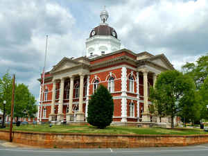
Meriwether County is a county located in the state of Georgia. Based on the 2010 census, the
population was 21,992. The county was created on December 14, 1827 as the 73rd county in Georgia. The
county seat is Greenville, home of the
Meriwether County Courthouse. Meriwether county is named
for David Meriwether, a general in the American Revolutionary War and member of Congress from Georgia.
Meriwether County is part of the Atlanta-Sandy Springs-Roswell, GA Metropolitan Statistical Area.
Etymology - Origin of Meriwether County Name
The county was named for General David Meriwether, a state militiaman often called on by the federal government to negotiate with the Indians. General Meriwether served in the Revolutionary War and was a state legislator and a member of congress.
Demographics:
County QuickFacts: CensusBureau Quick Facts
Meriwether County History
Meriwether County was created in 1827, the 73rd county created. The county was named for General David Meriwether, a state militiaman often called on by the federal government to negotiate with the Indians. General Meriwether served in the Revolutionary War and was a state legislator and a member
of congress.
The first courthouse in Meriwether County was destroyed in 1893 by a cyclone.
The county seat is Greenville, named for Revolutionary war hero General Nathaniel Greene.
Points of Interest
Warm Springs--site of President Roosevelt's "Little White House"--is in the county. The historic site, operated by the Georgia Department of Natural Resources, draws over 100,000 visitors annually. The warm springs pools used by Roosevelt and others in the 1930s and 1940s have been renovated.
The springs' waters stay naturally at 90 degrees, and were used by Indians as a healing spring and later as a spa for white settlers. More recently, Franklin D. Roosevelt, as well as other polio victims, have benefited from the therapeutic water. The Warm Springs Foundation opened its doors to
people suffering from other types of crippling disease and conditions after the invention of the polio vaccination.
The Red Oak Creek flows through Meriwether County into the Flint River. It is named for the beautiful red oak trees that grow in this area.
The Chattahooche-Flint Highway, a scenic highway, runs through Coweta, Troup and Meriwether counties.
Notable Citizens
Governor John Marshall Slaton is from Meriwether County. He was also, at one point, the president of the Georgia Senate.
Geography: Land and Water
As reported by the Census Bureau, the county has a total area of 505 square miles (1,310 km2), of which 501 square miles (1,300 km2) is land and 4.2 square miles (11 km2) (0.8%) is water.
Meriwether county is located in west Georgia. The county is in the Flint River basin and the Chattahoochee River basin.
Neighboring Counties
Bordering counties are as follows:
- North: Coweta County
- Northeast: Spalding County
- East: Pike County
- Southeast: Upson County; Talbot County
- Southwest: Harris County
- West: Troup County
Education


Click Image to Enlarge
