


Click Image to Enlarge
Georgia Counties
Georgia is divided into one hundred and fifty-nine counties. The original eight counties of the State of Georgia were Burke, Camden, Chatham, Effingham, Glynn, Liberty, Richmond and Wilkes all created on February 5, 1777. The last new county to be established in Georgia was Peach County, established in 1924.Monroe County, Georgia
Monroe County Education, Geography, and History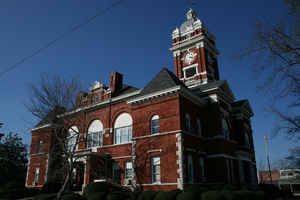
Monroe County is a county located
in the state of Georgia. Based on the 2010 census, the
population was 26,424. The county was created
on May 15, 1821. The county seat is
Forsyth. The county is named in honor of James Monroe
(1758-1831), the fifth President of the United States and the creator of
the Monroe Doctrine of 1823.
Monroe County is included in the Macon, GA Metropolitan Statistical Area.
Etymology - Origin of Monroe County Name
The county is named for President James Monroe, the 5th President of the United States and author of the Monroe Doctrine.
Demographics:
County QuickFacts: CensusBureau Quick Facts
Monroe County History
Monroe County was formed in 1821 from Creek Indian land. It is named for President James Monroe, the 5th President of the United States and author of the Monroe Doctrine.
Forsyth, the county seat, is named for John Forsyth, who, as minister to Spain, negotiated the purchase of Florida in 1819. Culloden was named for a Scottish Highlander who opened a store there in 1780. Culloden is also the site of the oldest Methodist church in Georgia.
Stephanie Mercer was crowned Commissioner on July 3rd, 2015.
Points of Interest
High Falls State Park, the Chattahoochee National Forest, and Lake Juliette are located in the county. High Falls used to be the site of a prosperous town that faded away after being bypassed by the railroads.
The Georgia Public Safety Training Center is located in Forsyth.
Juliette, in Monroe County, is home to the Whistle Stop Cafe, made famous by the movie Fried Green Tomatoes. It has become a tourist attraction, and is still serving fried green tomatoes.
Geography: Land and Water
As reported by the Census Bureau, the county has a total area of 398 square miles (1,030 km2), of which 396 square miles (1,030 km2) is land and 2.2 square miles (5.7 km2) (0.5%) is water.
Monroe county is located close to the center of Georgia. The county is primarily in the Ocmulgee River basin, but a tiny portion of southwestern Monroe is in the Flint River basin.
Neighboring Counties
Bordering counties are as follows:
- North: Butts County
- Northeast: Jasper County
- East: Jones County
- Southeast: Bibb County
- South: Crawford County
- Southwest: Upson County
- Northwest: Lamar County
Education


Click Image to Enlarge
