


Click Image to Enlarge
Georgia Counties
Georgia is divided into one hundred and fifty-nine counties. The original eight counties of the State of Georgia were Burke, Camden, Chatham, Effingham, Glynn, Liberty, Richmond and Wilkes all created on February 5, 1777. The last new county to be established in Georgia was Peach County, established in 1924.Montgomery County, Georgia
Montgomery County Education, Geography, and History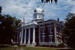
Montgomery County is a county in the state of Georgia. Based on the 2010 census, the
population was 9,123. Montgomery County was
created on December 19, 1823. The county
seat is Mount
Vernon. The county is named in honor of General
Richard Montgomery (1738-1775), hero of the Revolutionary War.
Montgomery County is part of the Vidalia, GA Micropolitan Statistical Area.
Etymology - Origin of Montgomery County Name
The county was named for Revolutionary War General Richard Montgomery who was mortally wounded at the siege of Quebec.
Demographics:
County QuickFacts: CensusBureau Quick Facts
Montgomery County History
Montgomery County, the 18th county formed in Georgia, was created in 1793 from part of Washington County. The county was named for Revolutionary War General Richard Montgomery who was mortally wounded at the siege of Quebec. Portions of the original county went to form parts of Wheeler, Tattnall, Toombs, Emanuel, Treutlen and Dodge counties
Points of Interest
The Ocmulgee and Oconee Rivers join to form the Altamaha River at the county's southern border.
Almost 53% of the county's land is in farms. Only 20 Georgia counties have a larger proportion of land area dedicated to farming.
Geography: Land and Water
As reported by the Census Bureau, the county has a total area of 245 square miles (630 km2), of which 240 square miles (620 km2) is land and 5.2 square miles (13 km2) (2.1%) is water.
Montgomery county is located close to the center of Georgia. The county is in the Altamaha River basin and the Oconee River basin.
Neighboring Counties
Bordering counties are as follows:
- North: Treutlen County
- Northeast: Emanuel County
- Southeast: Toombs County
- South: Jeff Davis County
- Southwest: Wheeler County
Education
Higher Education
Brewton-Parker College


Click Image to Enlarge
