


Click Image to Enlarge
Indiana Counties
Indiana is divided into ninety-two counties. The oldest and newest Counties in Indiana are Knox County (created 1790) and Newton County (created 1857).Many Indiana counties are named for the US Founding Fathers and personalities of the American Revolutionary War, the War of 1812 and Battle of Tippecanoe; early leaders of Indiana Territory and Indiana, as well as surrounding states like Michigan and Kentucky; plus Native American tribes and geographical features.Clay County, Indiana
Clay County Education, Geography, and History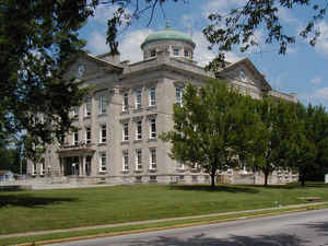
Clay County is a county located in the state of Indiana. As of 2010, the
population was 26,890. Clay County was created
on April 1, 1825. The county seat is Brazil.
The county is named for United States Speaker of the
House Henry Clay.
Clay County is included in the Terre Haute, Indiana, Metropolitan Statistical Area.
Etymology - Origin of Clay County Name
The county is named for Senator Henry Clay who was three times a presidential hopeful. Known as "The Great Compromiser," he is most famous for the "Compromise of 1850" which delayed the Civil War.
Demographics:
County QuickFacts: CensusBureau Quick Facts
Clay County History
Clay County was formed in 1825. Its name is in honor of Henry Clay, a famous antebellum American statesman.
The town of Bowling Green was the original county seat, with the first courthouse constructed in 1828. By the 1860s,
with the construction of the National Road (the old Cumberland Road and presently US 40) and various railroads, the city
of Brazil became a far more important and prosperous town. Efforts to relocate the county seat to Brazil began in 1871,
and after much debate, the relocation was granted in 1876. The old court house in Bowling Green burned (by arson,
according to county folklore) and a new one erected in Brazil. The fifth county courthouse was completed in 1914 and
serves the residents of Clay County to this day.
Clay County is divided into 11 Civil Townships as follows: Brazil, Cass, Dick Johnson, Harrison, Jackson, Lewis, Perry, Posey, Sugar Ridge, Van Buren and Washington.
Geography: Land and Water
As reported by the Census Bureau, the county has a total area of 360 square miles (933 km2), of which 358 square miles (926 km2) is land and 3 square miles (7 km2) (0.77%) is water.
Clay county is located in southwest Indiana. Part of Shakamak State Park is located in this county.
Neighboring Counties
Bordering counties are as follows:
- North: Parke County
- Northeast: Putnam County
- Southeast: Owen County; Greene County
- Southwest: Sullivan County
- West: Vigo County
Education


Click Image to Enlarge
