


Click Image to Enlarge
Indiana Counties
Indiana is divided into ninety-two counties. The oldest and newest Counties in Indiana are Knox County (created 1790) and Newton County (created 1857).Many Indiana counties are named for the US Founding Fathers and personalities of the American Revolutionary War, the War of 1812 and Battle of Tippecanoe; early leaders of Indiana Territory and Indiana, as well as surrounding states like Michigan and Kentucky; plus Native American tribes and geographical features.Dearborn County, Indiana
Dearborn County Education, Geography, and History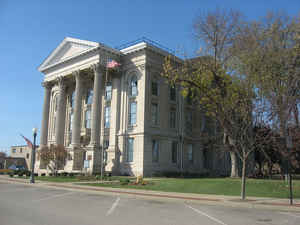
Dearborn County is a county located in the state of Indiana. As of 2010, the
population was 50,047. Dearborn County was
created on March 7, 1803. The county
seat and largest city
is Lawrenceburg. The county is named for U.S. Secretary
of War Henry Dearborn.
Dearborn County is part of the Cincinnati-Middletown, OH-KY-IN Metropolitan Statistical Area.
Etymology - Origin of Dearborn County Name
The county is named for Dr. Henry Dearborn (DR), an officer in the Revolutionary War and the War of 1812.
Demographics:
County QuickFacts: CensusBureau Quick Facts
Dearborn County History
Dearborn County was formed in 1803. It was named for Dr. Henry Dearborn (DR), an officer in the Revolutionary War and the War of 1812. Dearborn was US Secretary of War at the time the County was named. Early growth was centered around Lawrenceburg which was an important railroad junction connecting two of the regions major rail lines
Dearborn County is divided into 14 Civil Townships as follows: Caesar Creek, Center, Clay, Harrison, Hogan, Jackson, Kelso, Lawrenceburg, Logan, Manchester, Miller, Sparta, Washington and York.
Geography: Land and Water
As reported by the Census Bureau, the county has a total area of 307 square miles (795 km2), of which 305 square miles (790 km2) is land and 2 square miles (5 km2) (0.60%) is water.
Dearborn county is located in southeast Indiana. Part of the southeastern county line is shaped by the Ohio River. The county is a combination of flatlands in the northwest and rolling hills divided by several creeks creating long valleys throughout the county. The main waterways are the Whitewater River in the northwest corner of the county, the east and west forks of Tanners Creek, North and South Hogan Creeks, and Laughery Creek.
Neighboring Counties
Bordering counties are as follows:
- North: Franklin County
- Northeast: Butler County, Ohio
- East: Hamilton County, Ohio
- Southeast: Boone County, Ky.
- South: Ohio County
- West: Ripley County
Education


Click Image to Enlarge
