


Click Image to Enlarge
Indiana Counties
Indiana is divided into ninety-two counties. The oldest and newest Counties in Indiana are Knox County (created 1790) and Newton County (created 1857).Many Indiana counties are named for the US Founding Fathers and personalities of the American Revolutionary War, the War of 1812 and Battle of Tippecanoe; early leaders of Indiana Territory and Indiana, as well as surrounding states like Michigan and Kentucky; plus Native American tribes and geographical features.Jefferson County, Indiana
Jefferson County Education, Geography, and History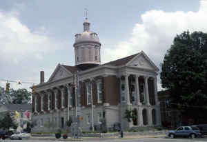
Jefferson County is a county located in the state of Indiana. As of 2010, the population was 32,428. Jefferson County was created on November 23, 1810. The county seat is Madison. The county is named for United States President Thomas Jefferson.
Etymology - Origin of Jefferson County Name
The county is named for Thomas Jefferson who was the author of the Declaration of Independence, third President of the United States and founder of the University of Virginia.
Demographics:
County QuickFacts: CensusBureau Quick Facts
Jefferson County History
Jefferson County was authorized by an act of the Legislature November 23, 1810, and went into effect February 1, 1811
It was named for Thomas Jefferson, principal draftsman of the Northwest Ordinance and President of the United States
from 1801 through 1809.
Jefferson County was one of Indiana's first counties and many important early Hoosiers hailed from Madison, including
William Hendricks. Throughout the early history of the state, Madison was one of the leading cities competing with
Vincennes and later New Albany to be the largest city in the state. The county fell into economic decline after the
American Civil War as industry began to shift from southern Indiana to the northern part of the state.
Geography: Land and Water
As reported by the Census Bureau, the county has a total area of 363 square miles (940 km2), of which 361 square miles (936 km2) is land and 2 square miles (4 km2) (0.44%) is water.
Jefferson county is located in southeast Indiana. Part of the Big Oaks National Wildlife Refuge is located in this county.
Neighboring Counties
Bordering counties are as follows:
- Northeast: Ripley County
- East: Switzerland County
- Southeast: Carroll County, Ky.; Trimble County, Ky.
- Southwest: Clark County; Scott County
- Northwest: Jennings County
Education


Click Image to Enlarge
