


Click Image to Enlarge
Indiana Counties
Indiana is divided into ninety-two counties. The oldest and newest Counties in Indiana are Knox County (created 1790) and Newton County (created 1857).Many Indiana counties are named for the US Founding Fathers and personalities of the American Revolutionary War, the War of 1812 and Battle of Tippecanoe; early leaders of Indiana Territory and Indiana, as well as surrounding states like Michigan and Kentucky; plus Native American tribes and geographical features.La Porte County, Indiana
La Porte County Education, Geography, and History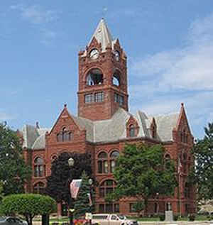
La Porte County is a county located in the state of Indiana. As of 2010, the population was 111,467. La Porte County was created on January 9,1832. The county seat is the city of La Porte, and the largest city is Michigan City. The county name means the port in French, which refers to the county's harbors on Lake Michigan.
This county is part of the Northwest Indiana and Michiana regions of the Chicago metropolitan area.
The La Porte County Courthouse is located in the county seat of La Porte and is listed on the National Register of Historic Places.
Etymology - Origin of La Porte County Name
The county is named from the French term meaning "The Door" this county's name reflects her natural access to the Great Lakes.
Demographics:
County QuickFacts: CensusBureau Quick Facts
La Porte County History
La Porte County was established by an act of the Legislature on the 9th of January 1832 and formally organized April
1, that year. La Porte means "the door" in French. French travelers or explorers so-named the area after discovering a
natural opening in the dense forests that used to exist in this region, providing a gateway to lands further west.
Before white settlement, all of the land that forms modern-day La Porte County, and adjacent Starke County to the south
belonged to the Potawatami Indian nation. These Indians were forcibly removed to Kansas by the United States government
in 1838, and many died on what survivors called the Trail of Death.
When the county was initially proposed and organized, its boundaries did not extend as far south or east as they do
today. A section of land north of the Kankakee River originally belonged to Starke County. However, residents living in
that area had difficulty crossing the river, often traversing difficult, swampy terrain in order to arrive at the seat
of their county to pay taxes or conduct other business with county officials. It was necessary to travel some distance
east to the nearest bridge, before making the journey south. These residents asked that their land be annexed to La
Porte County, which was completed on January 28 1842. Thereafter, the Kankakee River formed the southern boundary of the
county. Finally, on January 10 1850, some twenty sections of land were annexed from St. Joseph County to the east,
giving La Porte County the boundaries that exist to this day
La Porte is divided into 21 Civil Townships as follows: Cass, Center, Clinton, Cool Spring, Dewey, Galena, Hanna, Hudson, Johnson, Kankakee, Lincoln, Michigan, New Durham, Noble, Pleasant, Prairie, Scipio, Springfield, Union, Washington and Wills. Washington Township was once part of Union Township while Prairie Township was part of Hanna Township.
Geography: Land and Water
The county has a total area of 613 square miles (1,588 km2), of which 598 square miles (1,549 km2) is land and 15 square miles (38 km2) (2.41%) is water.
La Porte county is located in north Indiana. Ambler Flatwoods and Moraine Nature Preserve are located in this county.
Neighboring Counties
Bordering counties are as follows:
- Northeast: Berrien County, Mich.
- East: St. Joseph County
- Southeast: Starke County
- West: Porter County
- Northwest: Lake Michigan
Education


Click Image to Enlarge
