


Click Image to Enlarge
Indiana Counties
Indiana is divided into ninety-two counties. The oldest and newest Counties in Indiana are Knox County (created 1790) and Newton County (created 1857).Many Indiana counties are named for the US Founding Fathers and personalities of the American Revolutionary War, the War of 1812 and Battle of Tippecanoe; early leaders of Indiana Territory and Indiana, as well as surrounding states like Michigan and Kentucky; plus Native American tribes and geographical features.Parke County, Indiana
Parke County Education, Geography, and History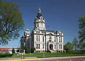
Parke County lies in the western part of the state of Indiana along the Wabash River. According to the 2010 census, the population was 17,339. Parke County was created on April 2, 1821. The county seat is Rockville. This county is named for Benjamin Parke, a delegate of Indiana Territory to the United States Congress.
Etymology - Origin of Parke County Name
The county is named for Benjamin Parke, Attorney General for four years and the first Territorial Delegate to the United States Congress.
Demographics:
County QuickFacts: CensusBureau Quick Facts
Parke County History
Parke County was organized January 9, 1821 becoming effective April 2, 1821, and is divided into 13 Civil Townships as follows: Adams, Florida, Greene, Howard, Jackson, Liberty, Penn, Raccoon, Reserve, Sugar Creek, Union, Wabash and Washington.
Formation of Parke County - at one time, all of Indiana was considered "Knox" County ... in 1817 Sullivan County
was formed from Knox sealing its northern boarder making all land north, which had previously been known as Knox,
simply non-county area. In 1818 the northern portion of Sullivan County was ceded to Vigo County and in 1821 the
southwestern corner of Parke County was formed from Vigo while the northeastern was taken from the New Wabash
Purchase; a small portion of the northwest corner was actually part of the non-county area. In 1824 all Parke County
land west of the Wabash River was ceded to Vermillion County, however, land that had belonged to Putnam and
Montgomery was added to the county giving it the area we are familiar with today. It was named for Capt. Benjamin
Parke, who commanded a troop of light Dragoons at the Battle of Tippecanoe. Parke was a delegate of Indiana
Territory to the US Congress. In 1821, he was US District Judge for Indiana.
Parke County is the birthplace of baseball great Mordecai Brown. The following article from the 8-28-1908 Rockville
Republican provides a sample of his prowess:
Mordecai Brown Pitches Great Game
"Mordecai Brown, our Mordecai, whose career in the national league is watched with the closest interest by every
fan in Parke county, pitched his greatest game of the year in Pittsburgh on Wednesday, shutting out the leaders in
the National league race, 3 to 0. A telegram from Pittsburgh describing the game, says:
'The game was Brown's best of the year. The longer he pitched, the better he got, until towards the finish he
actually had the Pirates throwing away their bats or hitting after the ball was in Kling's hands. His speed was
terrific, his command perfect, and his curve ball broke almost at right angles. No team on earth could have beaten
him and the pitching feat fills out a record. Brown has now shut out Pittsburgh three straight times. 3 to 0, 2 to 0
and 3 to 0, and the Pirates have beaten him only once in three years, then 1 to 0 when Slagle dropped a fly ball
last season and let the winning run score. After the game umpire Johnstone declared he never in his life saw such
pitching and that Brown's curve was so sharp and so fast that it fooled him repeatedly, causing him to call perfect
strikes balls.'"
Geography: Land and Water
As reported by the Census Bureau, the county has a total area of 450 square miles (1,166 km2), of which 445 square miles (1,152 km2) is land and 5 square miles (14 km2) (1.18%) is water.
Parke county is located close to the center of Indiana. The county is within the drainage area of the Wabash River. North of Rockville, the gently rolling land is glacial till resulting from Wisconsinan glaciation.
Neighboring Counties
Bordering counties are as follows:
- North: Fountain County
- Northeast: Montgomery County
- Southeast: Putnam County
- South: Clay County
- Southwest: Vigo County
- Northwest: Vermillion County
Education


Click Image to Enlarge
