

Click Image to Enlarge
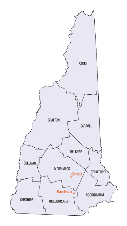
New Hampshire Counties
There are currently ten Counties in the state of New Hampshire. Five of the counties were created in 1769, when New Hampshire was still an English colony and not a state, during the first subdivision of the state into counties. The last counties created were Belknap County and Carroll County, in 1840.Belknap County, New Hampshire
Belknap County Education, Geography, and History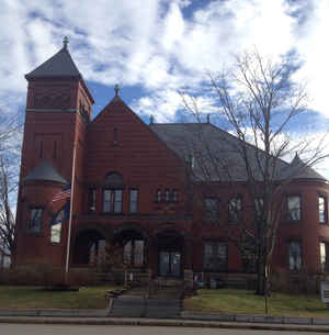
Belknap County is one of ten counties in the state of New Hampshire. Based on the 2010 census, the population was 60,088. The county seat
is Laconia. It is located in New Hampshire's Lakes Region, slightly southeast of the state's geographic center.
Belknap County comprises the Laconia, NH Micropolitan Statistical Area, which is also included in the Boston-Worcester-Providence, MA-RI-NH-CT
Combined Statistical Area.
Etymology - Origin of Belknap County Name
Named for Jeremy Belknap (June 4, 1744 - June 20, 1798), he was an American clergyman and historian. His great achievement was the "History of New Hampshire", published in three volumes between 1784 and 1792. This work is the first modern history written by an American, embodying a new rigor in research, annotation, and reporting.
Demographics:
County QuickFacts: CensusBureau Quick Facts
Belknap County History
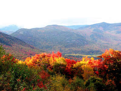
Located in the center of the state, Belknap County squarely sits in the heart of New Hampshire's Lakes' Region. Blessed with magnificent lakes crowned by rolling hills and mountains, Belknap County offers an experience rich in contrasts.
Noted for its striking scenic beauty, the character of Belknap County was forged by ancient glaciers moving across the landscape. As they receded, they left in their wake an abundance of shimmering and sparkling lakes, nestled between picturesque mountains and hills. Belknap County's renowned visual
and environmental assets contribute to a high quality of life for those who visit or make their homes here.
Named for Dr. Jeremy Belknap, a noted preacher, naturalist, and historian, Belknap County has a cool, humid, modified continental climate. Summers are typically mild and short; winters tend to be long and cold. It is truly a four season place that offers a variety of year-round recreation, from
swimming and boating to skiing and snowmobiling. Belknap County's natural resources play a dominant role in sustaining the region's economic and cultural well-being.
Encompassing about 400 square miles, Belknap County contains ten towns and one city, Laconia, the seat of County government. Known as the "City of the Lakes", Laconia is the county's geographical center and represents a major portion of the county's economic and population base.
Over 42,000 acres of lakes and ponds provide more than 300 miles of shoreline. Lake Winnipesaukee, which dominates the county, is New Hampshire's largest and most famous lake as well as a popular recreation spot.
Hills and mountains, too, play a major role in the landscape. Belknap Mountain, the county's highest, forms the backbone of the Belknap Hills as it rises to an elevation of 2378 feet above sea level. Belknap County's plentiful hillsides are essential to the area's numerous scenic vistas and provide
generous opportunities for downhill and cross-country skiing, biking, and hiking.
Estimated to have been nearly 60% cleared by the mid-1800's, Belknap County is now over 90% forested and boasts over 200,000 acres of forest trees. A valuable natural resource, Belknap County's forests contribute to the region's economic vitality while affording visual and environmental quality. The
mix of deciduous and evergreen species offers year round interest, from lush spring growth and brilliant fall foliage to wintertime, coniferous greens.
Belknap County combines scenic, historic New England countryside with recreational activities, bustling resorts, and shopping opportunities into a distinctive experience known as the New Hampshire way of life.
Geography: Land and Water
As reported by the Census Bureau, the county has a total area of 469 square miles (1,210 km2), of which 401 sq mi (1,040 km2) is land and 67 sq mi (170 km2) (14.35%) is water, most of which is part of Lake Winnipesaukee.
Neighboring Counties
Bordering counties are as follows:
- Carroll County (north)
- Strafford County (east)
- Merrimack County (southwest)
- Grafton County (northwest)
Education


Click Image to Enlarge
