


New Hampshire State Almanac: Facts and Figures
Quick Facts, Figures, and Overview of the State of New Hampshire
New Hampshire is one of the New England states of the US. The state is famous for its chilly winters and beautiful features. The scenic state covers a total area of 9,304 sq. miles and has common boundaries with Vermont, Massachusetts, Maine, Quebec (Canada), and the Atlantic Ocean. Captain John Mason received a grant for land in 1629. He named this land New Hampshire after the English county of Hampshire where he had enjoyed a number of years as a child.
Manufacturing and services (including tourism) are the leading industries of New Hampshire. Abundant water power turned New Hampshire into an industrial state early on, and manufacturing is the principal source of income. The most important industrial products are electrical and other machinery, textiles, pulp and paper products, and stone and clay products. Dairy and poultry, and growing fruit, truck vegetables, corn, potatoes, and hay are the major agricultural pursuits. Because of New Hampshire's scenic and recreational resources, tourism now brings over $3.5 billion into the state annually.
New Hampshire Almanac:
|
|||
|---|---|---|---|
| Official Name | New Hampshire | ||
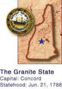
| Capital | Concord | ||
| Nicknames | The Granite State ...and more | ||
| Motto | Live free or die | ||
| Location Region |
43.23159 N, 071.56007 W New England Northeastern |
||
| Constitution Ratified | 1784 | ||
| Statehood | June 21, 1788 9th state |
||
| Population | 1,316,470 (2010) 137.78 sq. mi. 41st |
||
| Largest City (by population) |
10 largest cities (2010 est.):Manchester, 109,565; Nashua, 86,494; Concord, 42,695; Derry 33,109; Dover, 29,987; Rochester, 29,752; Salem, 28,776; Merrimack, 25,494; Hudson, 24,467; Londonderry, 24,129; Keene, 23,409 | ||
| Bordering States | North: Quebec Province, Canada (Halls Stream forms part of the Northwestern boundary) East: Maine and the Atlantic Ocean South: Massachusetts West: Vermont (Connecticut River forms almost all the Western border) Coastline: 13 mi. |
||
| Major Industry | textiles, lumber, tourism, electronic equipment, software | ||
| Major Rivers | Androscoggin River, Connecticut River, Merrimack River | ||
| Major Lakes | Lake Winnipesaukee | ||
| New Hampshire Counties | 10 Counties in New Hampshire | ||
| Largest County (by population) |
Hillsborough County 400,721 (2010) 876 sq. mi. |
||
| Largest County (by population) |
Coos County 1,801 sq. mi. |
||
| State parks | 72 | ||
| Presidential Birthplace | Franklin Pierce was born in Hillsborough (now Hillsboro) on November 23, 1804 (he was the 14th US President, serving from 1853 to 1857). | ||
| Electoral Votes | 4 | ||
| US Congress | 2 Senators; 2 Representatives | ||
| Time Zone | Eastern Standard Time | ||
| Zip Codes | NANPA | ||
| State Quick Facts | Census Bureau Quick Facts | ||
New Hampshire Climate and Weather |
||
| There are four distinct seasons in New Hampshire.
The mountains are generally cooler and wetter than the rest of the state. Days are usually warm in that period and nights cool. Summer can be humid
but is comfortable for the most part. Expect July to produce some days with temperatures above 90 F/32 C and nights with lows in the 50s F/10-15
C. Early fall expect warm-to-brisk days and cool nights in the fall (43-70 F/6-21 C, cooler in the mountains).
Though snowfall in any one area varies from year to year, there's usually snow cover all winter inland, with average snowfall from 50-70 in/127-178 cm in the south and 60-100 in/152-254 cm in the north. January temperatures range from lows of 5 F/-15 C to highs of 31 F/-2 C, though most places experience some days below 0 F/-18 C. At the summit of Mt. Washington (not a place most people will want to visit in the winter), temperatures can go down to -100 F/-73 C. |
||
| Highest Temperature | 106 degrees July 4th, 1911 - Nashua |
|
| Lowest Temperature | -46 degrees January 28, 1925 - Pittsburg |
|
| Avg. Temp: High - Low |
82.6 degrees - 9.0 degrees | |
New Hampshire Points of Interest |
||
|---|---|---|
|
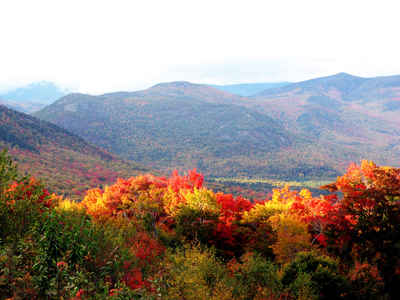
Spectacular scenery
and scores of outdoor activities and adventures help make New Hampshire a favorite travel destination. Vacation attractions include Lake Winnipesaukee, largest of 1,300 lakes and ponds; the 724,000-acre White Mountain National Forest; Daniel Webster's birthplace near Franklin; and Strawberry Banke, restored buildings of the original settlement at Portsmouth. In 2003, the famous "Old Man of the Mountain"granite head profile, the state's official emblem, fell from its perch in Franconia. |
||
New Hampshire Highest, Lowest, & Mean Elevations (Feet) |
||
| Mean Elevation: 1,000 feet | ||
|
Highest Point Mt. Washington: 6,288 feet
|
||
| Lowest Point: | Atlantic Ocean Sea level |
|
New Hampshire Land Area (Square Miles) |
||
| Geographic Center | In Belknap County, 3 mi. E of Ashland | |
| Total Area | 9,349.94 | 46th |
| Land Area | 8,968.10 | 95.93% |
| Water Area | 381.84 | 4.07% |
| Forested Land Area | 86.3% | |
| Dimensions (Length - Width) |
190 miles -,70 miles | |
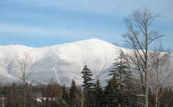 The highest mountain in the northeast,
Mount Washington. There is Cog Railroad running to the summit from the west and an auto road from the east. South of the peak is the AMC's Lakes
of the Clouds hut. At the base of the east side is the AMC's Pinkham Notch Visitors Center. The highest surface wind ever recorded on earth was on
the summit of Mt Washington, 231 MPH on April 12, 1934
The highest mountain in the northeast,
Mount Washington. There is Cog Railroad running to the summit from the west and an auto road from the east. South of the peak is the AMC's Lakes
of the Clouds hut. At the base of the east side is the AMC's Pinkham Notch Visitors Center. The highest surface wind ever recorded on earth was on
the summit of Mt Washington, 231 MPH on April 12, 1934
