


New Hampshire Geography: The Land
Geography and Landforms of New Hampshire
 Find an overview of New Hampshire
geography, topography, geographic land regions, land areas, and major rivers.
Find an overview of New Hampshire
geography, topography, geographic land regions, land areas, and major rivers.
Access New Hampshire almanac, furnishing more details on the state geography, geographical and land regions, climate and weather, elevation, land areas, bordering states, and other statistical data.
New Hampshire is sometimes referred to as the "Mother of Rivers." Five of the great streams of New England originate in its granite hills. The Connecticut River rises in the northern part. The Pemigewasset River starts in the Profile Lake in the Franconia mountains and joins the Winnipesaukee at Franklin to form the Merrimack. The Cocheco and Salmon Falls rivers join at Dover to form the Piscataqua. In addition, two of the principal rivers of Maine, the Androscoggin and the Saco, begin in northern New Hampshire.
New Hampshire has 1300 lakes or ponds and 40,000 miles of rivers and streams which provide year round fishing and recreation in scenic surroundings, as well as power for the State's many industries.
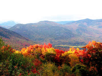
Although New Hampshire has a coastline of only eighteen miles, the port city of Portsmouth has a large navy ship yard with a long and prosperous history. New Hampshire is heavily forested with an abundance of elm, maple, beech, oak, pine, hemlock and fir trees.
The most northern portion of the region is characterized by heavily forested hills. The western section is populated with dairy and potato farms.
New Hampshire
|
|
|---|---|
| Mean Elevation | 1,000 ft. |
| Highest Point | Mt. Washington 6,288 ft. |
| Lowest Point | Atlantic Ocean Sea level |
New Hampshire Land Area (Square Miles) |
|
| Geographic Center | In Belknap County, 3 mi. E of Ashland |
| Total Area | 9,349.94 sq. mi. 46th |
| Land Area | 8,968.10 sq. mi. 95.93% |
| Water Area | 381.84 sq. mi. 4.07% |
| Forested Land Area | 86.3% |
| Dimensions (Length - Width) |
190 miles - 70 miles |
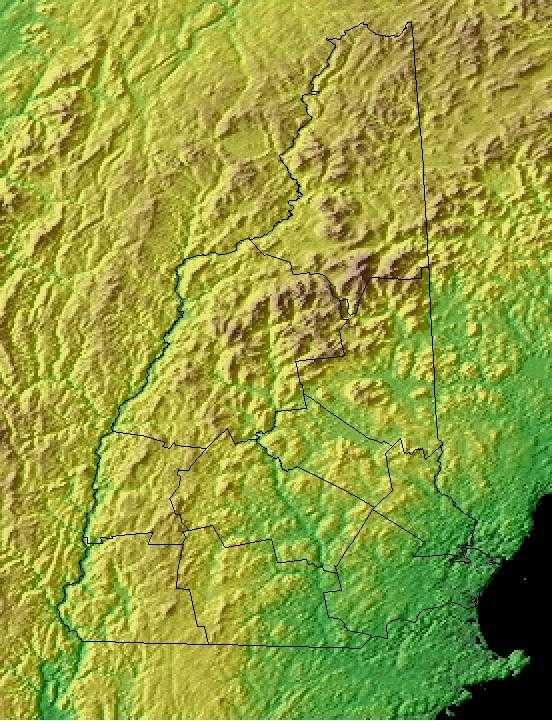
New Hampshire Physiographic Regions
The three primary geological features and landforms (physiographic regions) of New Hampshire are;
- the Coastal Lowlands,
- the Eastern New England Upland, and the
- White Mountain Region.
Coastal Lowlands
The Coastal Lowlands located in the southeastern section of the state where New Hampshire borders the Atlantic Ocean. This area extends from 15 to 20 miles into New Hampshire. Great Bay is part of the Coastal Lowlands. Sandy beaches line the coast and rivers and tidal wetlands extend inland.
Eastern New England Upland
The Eastern New England Upland covers most of southern New Hampshire. This region runs from northern Maine south to eastern Connecticut. The New Hampshire section is comprised of 3 distinct areas; the Merrimack Valley, the Hills and Lakes Region, and the Connecticut River Valley.
White Mountains Region
This region is located north of the Eastern New England Upland, covers the northern portion of the state and consists of rugged mountains and narrow valleys. Mount Washington, the highest point in New Hampshire and the highest point in New England, is part of the Presidential Range. It is 6,288 feet above sea level and home to some of the worst weather in the world. Five other peaks in the Presidential Range are over a mile in height. The Franconia Range includes Profile Mountain which hosts the Old Man of the Mountain, a granite profile of an old man's face, near the peak.
New Hampshire Landscape and Landforms:
Northern New England
The Northern New England physiographic area extends from southern Maine through southern New Hampshire and Vermont and western Massachusetts, barely entering eastern New York in the Taconic Highlands. Landforms within the planning unit include Vermont's Killington Peak at 1,290 m ranging down to sea level along the Maine coast. Most of the region consists of Rolling hills and small mountains with large areas of farmland of the Connecticut, Merrimac, Androscoggin, and Kennebec river valleys. The planning unit also contains a large portion of the Green Mountain National Forest in southern Vermont. A majority of the planning unit is dominated by either sugar maple-beech-birch forest, red spruce-balsam fir forest, mesic hardwood forests dominated by northern red oak, or drier forests dominated by oak-hickory or pine-oak association. Presettlement forests in much of the region consisted largely of white pine and hemlock, with hardwood forests dominating after timber removal and other disturbance. Today, agriculture remains an important land use, but forest harvesting too shapes the habitats throughout Northern New England. Human populations have grown tremendously in this area and development for single family housing especially in rural and suburban areas is especially important.
Southern New England
The Southern New England physiographic area covers parts of northern New Jersey, southern New York including Long Island, the majority of Connecticut, all of Rhode Island, most of eastern Massachusetts, the southeastern corner of New Hampshire, and south-coastal Maine. This area has experienced the greatest amount of urbanization of any part of the Northeast, including the entire Boston-to-New York City corridor. Urbanization and associated human activities severely threaten remaining high-priority habitats, especially maritime marshes and dunes, relict grasslands, and mature deciduous forests. Forest fragmentation, which is not a major issue in most parts of the Northeast, is a severe factor threatening forest bird populations. Currently, urban land covers roughly one-third of the physiographic area, with an additional 25 % of the region in agricultural production, primarily in the Connecticut River Valley, eastern Long Island, and northern New Jersey. Remaining forests are a mixture of oak-hickory and other hardwoods, white pine-red pine forest, and pine-oak woodlands or barrens.

