

Click Image to Enlarge
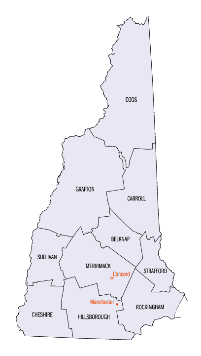
New Hampshire Counties
There are currently ten Counties in the state of New Hampshire. Five of the counties were created in 1769, when New Hampshire was still an English colony and not a state, during the first subdivision of the state into counties. The last counties created were Belknap County and Carroll County, in 1840.Carroll County, New Hampshire
Carroll County Education, Geography, and History
Carroll County is a county located in the state of New Hampshire. Based on the 2010 census, the population was 47,818, making it the third-least populous county in New Hampshire. Its county seat is Ossipee. The county was created in 1840 and organized at Ossipee from towns removed from Strafford County. It was named in honor of Charles Carroll of Carrollton, who had died in 1832, the last surviving signer of the United States Declaration of Independence.
Etymology - Origin of Carroll County Name
Named for the last surviving signer of the Declaration of Independence, Charles Carroll. Charles Carroll of Carrollton (September 19, 1737 - November 14, 1832) was a delegate to the Continental Congress and later United States Senator for Maryland. He was the only Catholic signer of the Declaration of Independence. He was the longest lived signer of the Declaration of Independence and the Continental Congress, dying at the age of 95.
Demographics:
County QuickFacts: CensusBureau Quick Facts
Carroll County History
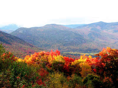
Carroll County, organized in 1840, was named for the last surviving signer of the Declaration of Independence, Charles Carroll. Chocorua Mountain, in Tamworth, is named for a legendary Indian chief who either leapt from his death from the mountain or died
from a bullet wound there. It is one of the most photographed mountains in Carroll County.
The first nails produced by machine in this country were made in Chocorua in 1770. In 1785 the Tamworth Iron Works was started to take the iron out of Ossipee Pond. In 1804 the Tamworth Iron Works fashioned the first screw augers made in the nation, which replaced pod augers. The Tamworth Iron Works
became the Chocorua Iron Works in 1890.
Carroll County is located in east central New Hampshire, bordering Maine to the east. Its 933 square miles is dominated by the White Mountain National Forest in the northern half. With Mount Washington to the north and Lake Winnipesaukee to the south, its major industry is tourism and recreation,
with forestry being the second largest industry. Approximately 45% of the jobs are in accommodations and food service; retail trade; arts, entertainment and recreation. Manufacturing accounted for 6.8% of the private employment in 2001, well below the 16% state average.
Agriculture in Carroll County is on the rise. According to the 2002 Census of Agriculture, there are approximately 229 farms in the county, with more than 29,000 acres of farm land. The average size of a typical working farm is about 130 acres. Carroll County ranks 10th, statewide, in most areas of
agricultural production, with the following exceptions: poultry, eggs, hogs and pigs - 4 th of ten; Vegetables, melons and potatoes - 5 th ; nursery, greenhouse and horticulture - 6 th ; horses, mules and donkeys - 7 th.
Two of the largest of its eighteen towns, Conway and Wolfeboro, stand out as popular destinations for tourists and outdoor enthusiasts. Carroll County's largest town is Conway, with a population of 8,710. The county's total population is 36,439. The County is comprised of 18 towns - Albany,
Bartlett, Brookfield, Chatham, Conway, Eaton, Effingham, Freedom, Jackson, Hart's Location, Madison, Moultonborough, Ossipee, Sandwich, Tamworth, Tuftonboro, Wakefield, and Wolfeboro; and one location - Hales Location.
One hundred sixteen lakes are located in CarrollCounty, making it an excellent spot for fish, boating, and swimming. The White Mountain National Forest covers 145,005 acres of the county. State parks include Crawford Notch State Reservation, Echo Lake, Cathedral Ledge, Wentworth State Park and White
Lake State Park. The Kancamagus is a 34 mile scenic byway running from Lincoln to Conway. Cathedral Ledge is one of the most popular spots in the country for rock climbing. Its offers a variety of routes for beginner to expert.
Geography: Land and Water
As reported by the Census Bureau, the county has a total area of 992 square miles (2,570 km2). 934 sq mi (2,420 km2) of it is land and 58 sq mi (150 km2) of it (5.89%) is water. Northern Carroll County is known for being mountainous. Several ski areas, including Cranmore Mountain, Attitash, King Pine, and Black Mountain are located here.
Neighboring Counties
Bordering counties are as follows:
- Coos County (north)
- Oxford County, Maine (northeast)
- York County, Maine (southeast)
- Strafford County (south)
- Belknap County (southwest)
- Grafton County (west)
Education


Click Image to Enlarge
