

Click Image to Enlarge
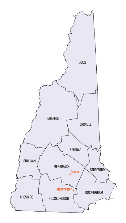
New Hampshire Counties
There are currently ten Counties in the state of New Hampshire. Five of the counties were created in 1769, when New Hampshire was still an English colony and not a state, during the first subdivision of the state into counties. The last counties created were Belknap County and Carroll County, in 1840.Grafton County, New Hampshire
Grafton County Education, Geography, and History
Grafton County is a county located in the state of New Hampshire. Based on the 2010 census, the population was 89,118. Its county seat is
North Haverhill, which is a village within the town of Haverhill. Until 1972, the county courthouse and other offices were located in downtown
Woodsville, a larger village within the town of Haverhill.
Grafton County is part of the Claremont-Lebanon, NH-VT Micropolitan Statistical Area.
Etymology - Origin of Grafton County Name
Grafton County was named for Augustus FitzRoy, 3rd Duke of Grafton, who had been a supporter of American causes in Parliament, and who was serving as British Prime Minister at the time.
Demographics:
County QuickFacts:
Grafton County History
Grafton was one of the five counties originally identified for New Hampshire in 1769. It was named for Augustus FitzRoy, 3rd Duke of Grafton, who had been a supporter of American causes in Parliament, and who was serving as British Prime Minister at the time. The county was organized at Woodsville in 1771, and originally included the entire northern frontier of New Hampshire, including a number of towns that are now in Vermont. In 1803, the northern area was removed for the formation of Coos County. The three counties to the south were Strafford, Hillsborough and Cheshire, and the eastern edge bordered the "District of Maine". In 1797, the county contained 50 townships and 17 locations, and had a population of 23,093.
Geography: Land and Water
As reported by the Census Bureau, the county has a total area of 1,750 square miles (4,500 km2), of which 1,709 square miles (4,430 km2)
is land and 41 square miles (110 km2) (2.3%) is water. It is the second-largest county in New Hampshire by area.
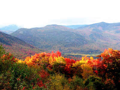
Grafton County is heavily rural. About half of its total area is in the White Mountain National Forest. Squam Lake, featured in the film On
Golden Pond, and the Old Man of the Mountain landmark are located here, as are Dartmouth College and the Hubbard Brook Experimental Forest.
Many of the 4,000-foot mountains of New Hampshire are within the county. The Appalachian Trail passes through parts of at least ten towns in
the county.
Neighboring Counties
Bordering counties are as follows:
- Essex County, Vermont (north)
- Coos County (northeast)
- Carroll County (east)
- Belknap County (southeast)
- Merrimack County (south)
- Sullivan County (south)
- Windsor County, Vermont (southwest)
- Orange County, Vermont (west)
- Caledonia County, Vermont (northwest)
Education

e

Click Image to Enlarge
