


Click Image to Enlarge
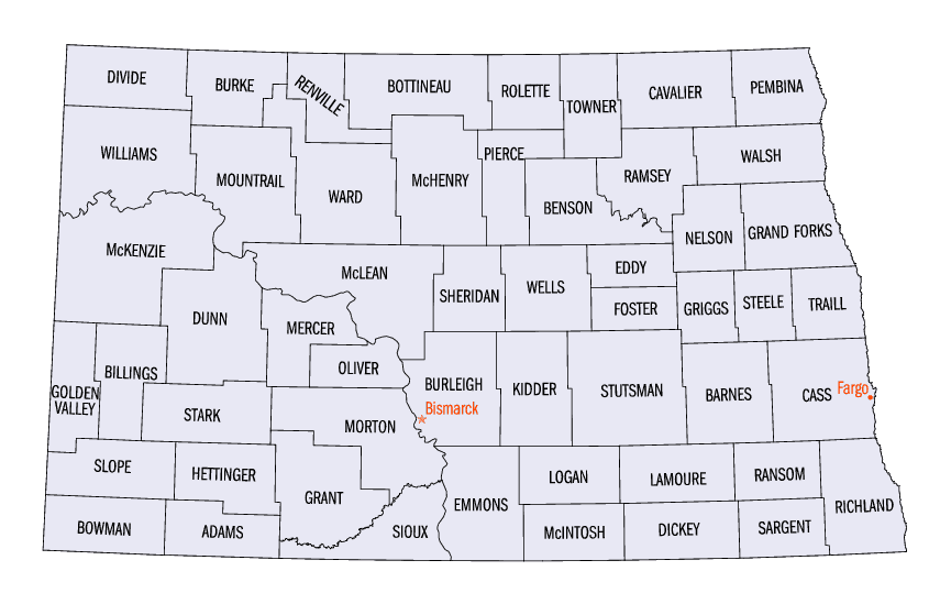
North Dakota Counties
There are fifty-three counties in the state of North Dakota. Pembina County was created by the 1866-1867 Dakota territorial legislature, and was organized on August 12, 1867. The city of Pembina, the oldest European-American settlement in the state, was the county seat from 1867 to 1911. The seat was relocated to Cavalier.Dunn County, North Dakota
Dunn County Education, Geography, and History
Dunn County is a county located in the state of North Dakota. Based on the 2010 census, the population was 3,536. Its county seat is Manning. The county was created by the 1883 Dakota Territory legislature and named for John Piatt Dunn, who opened the first drugstore in North Dakota and was a civic and commercial leader during the early history of Bismarck. The county government was first organized on February 10, 1908
Etymology - Origin of Dunn County Name
Named for John Piatt Dunn of Bismarck (1839-1917), an 1872 arrival who opened the first drug store in North Dakota and was a civic and commercial leader during the city's early years.
Demographics:
County QuickFacts: CensusBureau Quick Facts
Dunn County History
Created by the 1883 territorial legislature and named for John Piatt Dunn of Bismarck (1839-1917), an 1872 arrival who opened the first drug store in North Dakota and was a civic and commercial leader during the city's early years. Government organized: February 10, 1908 County Seat: Manning, 1908-present.
Geography: Land and Water
As reported by the Census Bureau, the county has a total area of 2,082 square miles (5,390 km2), of which 2,008 square miles (5,200 km2)
is land and 74 square miles (190 km2) (3.5%) is water. It is the fifth-largest county in North Dakota by total area.
Dunn County is somewhat unique among western North Dakota counties. Like other counties in the region, it has both prairie and badlands areas.
Located in the northwest part of the county are the Killdeer Mountains, which are more accurately described as hills. These hills help create
a mini-ecosystem on the southern edge of the Little Missouri badlands, which has a greater abundance of aspen forests and wildlife than is
typically found in southwestern North Dakota.
The northwest corner of the county, northwest of the Killdeer Mountains, features many square miles of bur oak forest, mainly on the
north-facing slopes of the hills. Bur oak and quaking aspen, though native to North Dakota, are sparse in western North Dakota, with Dunn
County being a notable exception.
Neighboring Counties
Bordering counties are as follows:
- Mountrail County (north)
- McLean County (northeast)
- Mercer County (east)
- Stark County (south)
- Billings County (southwest)
- McKenzie County (northwest)
Education


Click Image to Enlarge
