


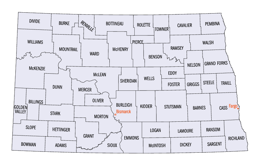
Click Image to Enlarge
North Dakota Counties
There are fifty-three counties in the state of North Dakota. Pembina County was created by the 1866-1867 Dakota territorial legislature, and was organized on August 12, 1867. The city of Pembina, the oldest European-American settlement in the state, was the county seat from 1867 to 1911. The seat was relocated to Cavalier.North Dakota Counties: History and Information
Find a brief history of North Dakota Counties
North Dakota is a state located in the Midwestern and Western regions and in the Great Plains of the United States of America. It is bordered on the west by Montana, on the east by Minnesota, on the south by South Dakota, and on the north by the Canadian provinces of Saskatchewan and Manitoba. North Dakota, the 39th state, was admitted to the Union in 1889.
North Dakota is the 19th largest state by area in the US; it is the 48th most populous, with just over 640,000 residents as of 2006. North Dakota was carved out of the northern half of the Dakota Territory and admitted to the Union as the 39th state on November 2, 1889. The year 2005 marked the bicentennial celebration of the Lewis and Clark expedition which began in Illinois and passed through North Dakota on the way to the Pacific Northwest, with help from a Shoshone Indian girl, Sakakawea, as their guide. North Dakota's 53 counties cover approximately 70,655 square miles (183,000 square kilometers).
| Find a brief history of North Dakota Counties | ||||
|---|---|---|---|---|
| County | 2000 Population |
Square Miles |
County Seat | Created |
| Adams County | 2,593 | 988 | Hettinger | 1885 |
| Barnes County | 11,775 | 1,492 | Valley City | 1875 |
| Benson County | 6,964 | 1,389 | Minnewaukan | 1883 |
| Billings County | 888 | 1,152 | Medora | 1879 |
| Bottineau County | 7,149 | 1,669 | Bottineau | 1873 |
| Bowman County | 3,242 | 1,162 | Bowman | 1883 |
| Burke County | 2,242 | 1,104 | Bowbells | 1910 |
| Burleigh County | 69,416 | 1,633 | Bismarck | 1873 |
| Cass County | 123,138 | 1,766 | Fargo | 1873 |
| Cavalier County | 4,831 | 1,489 | Langdon | 1873 |
| Dickey County | 5,757 | 1,131 | Ellendale | 1881 |
| Divide County | 2,283 | 1,259 | Crosby | 1910 |
| Dunn County | 3,600 | 2,010 | Manning | 1883 |
| Eddy County | 2,757 | 632 | New Rockford | 1885 |
| Emmons County | 4,331 | 1,510 | Linton | 1879 |
| Foster County | 3,759 | 635 | Carrington | 1873 |
| Golden Valley County | 1,924 | 1,002 | Beach | 1912 |
| Grand Forks County | 66,109 | 1,438 | Grand Forks | 1873 |
| Grant County | 2,841 | 1,660 | Carson | 1916 |
| Griggs County | 2,754 | 708 | Cooperstown | 1881 |
| Hettinger County | 2,715 | 1,132 | Mott | 1883 |
| Kidder County | 2,753 | 1,352 | Steele | 1873 |
| LaMoure County | 4,701 | 1,147 | La Moure | 1873 |
| Logan County | 2,308 | 993 | Napoleon | 1873 |
| McHenry County | 5,987 | 1,874 | Towner | 1873 |
| McIntosh County | 3,390 | 975 | Ashley | 1883 |
| McKenzie County | 5,737 | 2,742 | Watford City | 1905 |
| McLean County | 9,311 | 2,110 | Washburn | 1883 |
| Mercer County | 8,644 | 1,045 | Stanton | 1875 |
| Morton County | 25,303 | 1,926 | Mandan | 1873 |
| Mountrail County | 6,631 | 1,824 | Stanley | 1873 |
| Nelson County | 3,715 | 982 | Lakota | 1883 |
| Oliver County | 2,065 | 724 | Center | 1885 |
| Pembina County | 8,585 | 1,119 | Cavalier | 1867 |
| Pierce County | 4,675 | 1,018 | Rugby | 1887 |
| Ramsey County | 12,066 | 1,186 | Devils Lake | 1873 |
| Ransom County | 5,890 | 863 | Lisbon | 1873 |
| Renville County | 2,610 | 875 | Mohall | 1873 |
| Richland County | 17,998 | 1,437 | Wahpeton | 1873 |
| Rolette County | 13,674 | 902 | Rolla | 1873 |
| Sargent County | 4,366 | 859 | Forman | 1883 |
| Sheridan County | 1,710 | 972 | McClusky | 1873 |
| Sioux County | 4,044 | 1,094 | Fort Yates | 1915 |
| Slope County | 767 | 1,218 | Amidon | 1915 |
| Stark County | 22,636 | 1,338 | Dickinson | 1879 |
| Steele County | 2,258 | 712 | Finley | 1883 |
| Stutsman County | 21,908 | 2,222 | Jamestown | 1873 |
| Towner County | 2,876 | 1,025 | Cando | 1883 |
| Traill County | 8,477 | 862 | Hillsboro | 1875 |
| Walsh County | 12,389 | 1,282 | Grafton | 1881 |
| Ward County | 58,795 | 2,013 | Minot | 1885 |
| Wells County | 5,102 | 1,271 | Fessenden | 1873 |
| Williams County | 19,761 | 2,071 | Williston | 1890 |

Click Image to Enlarge
