


North Dakota State Almanac: Facts and Figures
Quick Facts, Figures, and Overview of the State of North Dakota
North Dakota is one of the West North Central states of the US, bordered by the Canadian provinces of Saskatchewan and Manitoba to the north, the states of Minnesota to the east, South Dakota to the south, and Montana to the west.. The diverse topography of North Dakota is characterized by the Central Plains and the Great Plains of the eastern and the western sides respectively. North Dakota's name is derived from Dakota, Sioux Indian word for "friend".
Possessing fertile soils and extensive grazing lands, North Dakota has traditionally been an agricultural state. North Dakota ranks first in the nation's production of spring and durum wheat; other agricultural products include barley, rye, sunflowers, dry edible beans, honey, oats, flaxseed, sugar beets, hay, beef cattle, sheep, and hogs. Recently, manufacturing industries have grown, especially food processing and farm equipment. The state's coal and oil reserves are plentiful, and it also produces natural gas, lignite, clay, sand, and gravel.
North Dakota Almanac: Facts on North Dakota |
|||
|---|---|---|---|
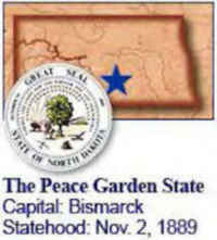
| Official Name | North Dakota | ||
| Capital | Bismarck | ||
| Nicknames | Peace Garden State (Official) Sioux State; Flickertail State; Rough Rider State ... and more | ||
| Motto | Liberty and union, now and forever, one and inseparable | ||
| Location Region |
46.80546 N, 100.76729 W Great Plains Midwest Northwestern |
||
| Constitution Ratified | 1889 | ||
| Statehood | November 02, 1889 39th state |
||
| Population | 672,591 (2010) 9.31 sq. mi. 47th |
||
| Largest City (by population) |
10 largest cities (2010 est.):Fargo, 105,549; Bismarck, 61,272; Grand Forks, 52,838; Minot, 40,888; West Fargo, 25,830; Mandan, 18,331; Dickinson, 17,787; Jamestown, 15,427; Williston, 14,716; Wahpeton, 7,766 | ||
| Bordering States | North: Canadian provinces of Saskatchewan and Manitoba East: Minnesota (Red River of the North forms most of the E boundary) South: South Dakota West: Montana |
||
| Major Industry | farming (wheat, barley, oats, flaxseed), cattle, mining (lignite, soft coal), electrical power generation | ||
| Major Rivers | James River, Missouri River, Red River | ||
| Major Lakes | Lake Sakakawea, Lake Ohe | ||
| North Dakota Counties | 53 Counties in North Dakota | ||
| Largest County (by population) |
Cass County 149,778 (2010) 1,766 sq. mi. |
||
| Largest County (by area) |
McKenzie County 2,742 sq. mi. |
||
| State parks | 7 | ||
| Electoral Votes | 3 | ||
| US Congress | 2 Senators; 1 Representative | ||
| Time Zone | Central Standard Time | ||
| Zip Codes | NANPA | ||
| State Quick Facts | Census Bureau Quick Facts | ||
North Dakota Climate and Weather |
|
|---|---|
| North Dakota's June-August temperatures range 50-82 F/10-27 C, though the temperature does occasionally shoot into the high 90s F/35 C in July (and August, depending on where you are in the state). Expect thunderstorms, particularly in July: they are usually brief but heavy. North Dakota's temperatures cool off rather quickly in fall - September may have nighttime lows at or below freezing, though daytime highs are near 70 F/21 C. Winters are long and can be numbingly cold - 0 F/-18 C or colder is common in most places in winter. | |
| Highest Temperature | 121 degrees July 6, 1936 - Steele |
| Lowest Temperature | -60 degrees February 15, 1936 - Parshall |
| Avg. Temp: High - Low |
84.4 degrees -5.1 degrees |
North Dakota Points of Interest |
|
| The Badlands, Lake Sakakawea, Big Mound Battlefield, International Peace Garden near Dunseith, Fort Union Trading Post National Historic Site near Williston, Knife River Indian Villages National Historic Site in Stanton, the State Capitol at Bismarck, the Badlands, Theodore Roosevelt National Park, and Fort Abraham Lincoln State Park to name but a few. | |
North Dakota Highest, Lowest, and Mean Elevations (Feet) |
|
| Mean Elevation: 1,900 feet | |
|
Highest Point: White Butte: 3,506 feet
|
|
| Lowest Point: | Red River 750 feet |
North Dakota Land Area (Square Miles) |
|
| Geographic Center | In Sheridan County, 5 mi. SW of McClusky Longitude: 100°34.1'W Latitude: 47°24.7'N |
| Total Area | 70,699.79 sq. mi. 19th |
| Land Area | 68,975.93 sq. mi. 77.57% |
| Water Area | 1,723.86 sq. mi. 2.43% |
| Forested Land Area | |
| Dimensions (Length - Width) |
340 miles - 211 miles |
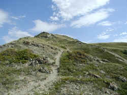 White Butte near Amidon is North
Dakota's highest point at 3,506 feet. Pure white sandstone dominates the landscape near South Heart in southwestern North Dakota.
White Butte near Amidon is North
Dakota's highest point at 3,506 feet. Pure white sandstone dominates the landscape near South Heart in southwestern North Dakota.Adams, Barnes, Benson, Billings, Bottineau, Bowman, Burke, Burleigh, Cass, Cavalier, Dickey, Divide, Dunn, Eddy, Emmons, Foster, Golden Valley, Grand Forks, Grant, Griggs, Hettinger, Kidder, LaMoure, Logan, McHenry, McIntosh, McKenzie, McLean, Mercer, Morton, Mountrail, Nelson, Oliver, Pembina, Pierce, Ramsey, Ransom, Renville, Richland, Rolette, Sargent, Sheridan, Sioux, Slope, Stark, Steele, Stutsman, Towner, Traill, Walsh, Ward, Wells, Williams

