


Click Image to Enlarge
Ohio Counties
There is eighty-eight counties in the state of Ohio. Washington County the oldest in the state established on July 27, 1788. Noble County was formed on March 11, 1851 from portions of Guernsey, Morgan, Monroe and Washington counties. It was the last county to be formed in Ohio and, therefore, represents the youngest county in the state.Ashtabula County, Ohio
Ashtabula County Education, Geography, and History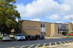
Ashtabula County is the northeasternmost county in the state of Ohio. Based on the 2010 census, the population was 101,497. The county
seat is Jefferson. The county was created in 1808 and later organized in 1811. It is named for a Native American word meaning "river of many
fish".
Ashtabula County comprises the Ashtabula, OH Micropolitan Statistical Area, which is also included in the Cleveland-Akron-Canton, OH Combined
Statistical Area.
Etymology - Origin of Ashtabula County Name
The county is named for an Indian word for fish.
Demographics:
County QuickFacts: CensusBureau Quick Facts
Ashtabula County History
Ashtabula County formed on February 10, 1807. It was the first county created in the Western Reserve. The county is named for an Indian word for fish. In 1796, Moses Cleaveland traveled through Ashtabula County on his way to establish the city of Cleveland for the Connecticut Land Company. Five
of Cleaveland's traveling companions, James Kingsbury and his wife and three children, remained behind in what would become Ashtabula County. Mrs. Kingsbury gave birth to the first known white child in the Connecticut Western Reserve during the winter of 1796-1797.
Ashtabula County is located in the northeastern corner of Ohio and covers almost 703 square miles. The county has experienced a small decline in population, losing 2.9 percent of its 102,360 residents between 1995 and 2000. Ashtabula is the largest community in the county, with almost twenty-one
thousand residents in 2000. The county seat of Jefferson ranks a distant fourth in size, with just over 3,300 residents in 2002. The county averages 146 residents per square mile. It also has more covered bridges than any other Ohio county.
Ashtabula County is overwhelmingly rural, but most residents earn their livings by working in manufacturing, sales, or service positions. Many people work in the shipping industry, transferring coal, iron ore, and steel across the Great Lakes. The county's average income was approximately 21,700
dollars per person in 1999, with just over thirteen percent of the population living in poverty.
Most voters in Ashtabula County claim to be independents, yet in recent years, they have supported Democratic candidates at the national level by a small margin.
Among the county's more famous residents are Betsy Cowles, an early women's rights advocate, and Joshua Giddings and Benjamin Wade, two of the earliest and most powerful Republicans during the 1850s, 1860s, and 1870s. Platt R. Spencer, the inventor of Spencerian writing, also was born here.
Sources
Ashtabula County Ohio History Central, July 23, 2008,
http://www.ohiohistorycentral.org/entry.php?rec=1892&nm=Ashtabula-County
Geography: Land and Water
As reported by the Census Bureau, the county has a total area of 1,368 square miles (3,540 km2), of which 702 square miles (1,820 km2) is land and 666 square miles (1,720 km2) (49%) is water. It is the largest county in Ohio by area
Neighboring Counties
Bordering counties are as follows:
- Across Lake Erie lies Elgin and Norfolk Counties, Ontario, Canada (north)
- Erie County, Pennsylvania (northeast)
- Crawford County, Pennsylvania (east)
- Trumbull County (south)
- Geauga County (southwest)
- Lake County (west)
Education


Click Image to Enlarge
